Related Research Articles

Cox's Bazar is a district in the Chittagong Division of Bangladesh. It is named after Cox's Bazar town. It is located 150 kilometres (93 mi) south of Chittagong. Cox's Bazar is also known by the names Panowa and Palongkee. The modern Cox's Bazar derives its name from Captain Hiram Cox, an army officer who served in British India. It is one of the fishing ports of Bangladesh, and contains one of the world's longest natural sea beaches.

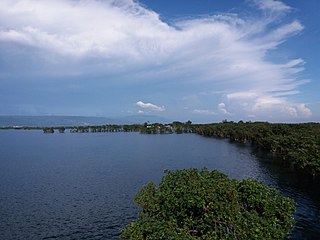
The Sundarbans National Park is a national park in West Bengal, India, and core part of tiger reserve and biosphere reserve. It is part of the Sundarbans on the Ganges Delta and adjacent to the Sundarban Reserve Forest in Bangladesh. It is located to south-west of Bangladesh. The delta is densely covered by mangrove forests, and is one of the largest reserves for the Bengal tiger. It is also home to a variety of bird, reptile and invertebrate species, including the salt-water crocodile. The present Sundarban National Park was declared as the core area of Sundarban Tiger Reserve in 1973 and a wildlife sanctuary in 1977. On 4 May 1984 it was declared a national park. It is a UNESCO World Heritage Site inscribed in 1987, and it has been designated as a Ramsar site since 2019. It is considered as a World Network of Biosphere Reserve from 1989.

Sundarbans is a mangrove forest area in Ganges Delta formed by the confluence of the Ganges, Brahmaputra and Meghna Rivers in the Bay of Bengal. Spread across parts of India and Bangladesh, this forest is the largest mangrove forest in the world. It spans the area from the Baleswar River in Bangladesh's division of Khulna to the Hooghly River in India's state of West Bengal. It comprises closed and open mangrove forests, land used for agricultural purpose, mudflats and barren land, and is intersected by multiple tidal streams and channels. Sundarbans is home to the world's largest area of mangrove forests. Four protected areas in the Sundarbans are enlisted as UNESCO World Heritage Sites, viz. Sundarbans West (Bangladesh), Sundarbans South (Bangladesh), Sundarbans East (Bangladesh) and Sundarbans National Park (India).

Saint Martin Island is a small coral island in the northeastern part of the Bay of Bengal, about 9 km south of the tip of the Cox's Bazar-Teknaf peninsula, and forming the southernmost part of Bangladesh. It has an area of only 3 km2. There is a small adjoining island that is separated at high tide, called Chhera Dwip. It is about 8 kilometres west of the northwest coast of Myanmar, at the mouth of the Naf River. It is also Bangladesh's only coral island.
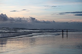
Cox's Bazar is a city, fishing port, tourism centre, and district headquarters in southeastern Bangladesh. Cox's Bazar Beach, one of the most popular tourist attractions in Bangladesh, is the longest uninterrupted naturally occurring sea beach in the world. Located 150 km (93 mi) south of the city of Chittagong, Cox's Bazar is also known by the name Panowa, which translates literally as "yellow flower." An old name was "Palongkee".

Teknaf is an upazila of Cox's Bazar District in the Division of Chittagong, Bangladesh. It forms the southernmost point in mainland Bangladesh. The name of the region comes from the Naf River which forms the Eastern boundary of the upazila. It shares a border with Myanmar, opposite the town of Maungdaw.

Sonadia Island is a small island of about 9 km2 (3.5 sq mi), off the Cox's Bazar coast of Chittagong Division, Bangladesh. Sonadia is located at Kutubjom Union in Maheshkhali Upazila, 15 km north-west of Cox's Bazar District Headquarters. It is located at latitude 21.28˝-21.33˝ and longitude 91.50˝-91.56˝. Sonadia Maheshkhali is separated from the main island by a canal.
A haor is a wetland ecosystem in the north eastern part of Bangladesh which physically is a bowl or saucer shaped shallow depression, also known as a backswamp. During monsoons haors receive surface runoff water from rivers and canals to become vast stretches of turbulent water.

Hakaluki Haor is a marsh wetland ecosystem of north-eastern Bangladesh. It is one of Bangladesh's largest and one of Asia's large marsh wetland resources. The haor is bounded by the Kushiara river as well as a part of the Sonai Bardal river to the north, by the Fenchuganj-Kulaura railway to the west and to the south, and by the Kulaura-Beanibazar road the east. It lies between 24°35’ N to 24°44’ N and 92°00’ E to 92°08’ E.
Bangladesh Environment Conservation Act (BECA) is set of laws enacted by the government of Bangladesh in 1995 to conserve the nation's environment. Its main goals were to "provide for conservation of the environment, improvement of environmental standards and control and mitigation of environmental pollution."(Bangladesh Environmental Conservation Act, 1995).

Tourism in Bangladesh includes tourism to World Heritage Sites, historical monuments, resorts, beaches, picnic spots, forests, tribal people, and wildlife of various species. Activities for tourists include angling, water skiing, river cruising, hiking, rowing, yachting, beachgoing and sea bathing.

Cox's Bazar Beach, located at Cox's Bazar, Bangladesh, is the longest natural sea beach in the world running 120 kilometres (75 mi) and 5th longest beach after Praia do Cassino of Brazil, Padre Island on the US Gulf Coast, Eighty Mile Beach in Western Australia, and Ninety Mile Beach of Australia. It is the top tourist destination of Bangladesh.
Global mangrove distributions have fluctuated throughout human and geological history. The area covered by mangroves is influenced by a complex interaction between land position, rainfall hydrology, sea level, sedimentation, subsidence, storms and pest-predator relationships). In the last 50 years, human activities have strongly affected mangrove distributions, resulting in declines or expansions of worldwide mangrove area. Mangroves provide several important ecological services including coastal stabilization, juvenile fish habitats, and the filtration of sediment and nutrients). Mangrove loss has important implications for coastal ecological systems and human communities are dependent on healthy mangrove ecosystems. This article presents an overview of global mangrove forest biome trends in mangrove ecoregions distribution, as well as the cause of such changes.

Bintuni Bay is the eastward extension or inner bay of Berau Gulf in western New Guinea. It separates the Bird's Head Peninsula on the north from the Bomberai Peninsula on the south. Administratively it is part of West Papua, Indonesia. The bay is 12 miles (19.3 km) wide at its entrance and there are extensive marshes along the shore.

Teknaf Wildlife Sanctuary is a protected area in the Cox's Bazar District of southern Bangladesh comprising a hill forest area of 11,615 ha (44.85 sq mi). In the east it is bordered by the Naf River, and in the west by the Bay of Bengal. It was established in 1983. It was once called Teknaf Game Reserve and is the only game reserve forest in the country. This is one of the few places in Bangladesh where Asian elephants can be seen in the wild. This vast sub-tropical forest has several other attractions like Nitong Hill, Kudum Cave, Kuthi Hill etc. The popular Toinga Peak has an elevation of about 1000 feet. This Sanctuary is rich in biodiversity.
WildTeam is an international conservation organisation which began in 2003 as The Wildlife Trust of Bangladesh and the Sundarbans tiger project. The Sundarbans Tiger project started out as a Bangladesh Forest Department and University of Minnesota research initiative; focusing on the ecology and conservation of tigers in the Bangladesh Sundarbans. Between 2003 and 2008, the Wildlife Trust of Bangladesh carried out research and education work in relation to Bengal tiger, Hoolock gibbon, Asian elephant, and Asian black bear.
Environmental impact of development in the Sundarbans, is the study of environmental impact on Sundarban, the largest single tract mangrove forest. It consist of a geographical area of 9,629 square kilometres (3,718 sq mi), including 4,185 square kilometres (1,616 sq mi) of reserve forest land, and is a natural region located partly in southern Bangladesh and partly in the Indian state of West Bengal. It is ecologically a southern part of the Gangetic delta between the Hooghly river in India on the west and the Meghna river in Bangladesh on the east and is bounded by the Ganga-Padma, the Padma-Meghna on the north and by the Bay of Bengal on the south. The area that is not reserve forest land is inhabited by human settlements with a total population around 4 million (2003).

Teknaf Beach is a part of Cox's Bazar Beach, located at Teknaf Upazila of Cox's bazar district. Teknaf beach is surrounded by the Teknaf peninsula mangrove area. This beach is divided into sections; Shamlapur Beach, Shilakhali Beach, Hajampara Beach, and Shapuree Island Beach.
Mangroves in India are coastal ecosystems characterized by salt-tolerant trees and shrubs, found predominantly along the eastern and western coastlines and in the Andaman and Nicobar Islands. It forms habitat for diverse wildlife, protect shorelines from erosion, and serve as natural barriers against extreme weather events. India hosts some of the largest mangrove forests in the world, including the Sundarbans, Bhitarkanika, and the Krishna-Godavari delta regions, each with unique ecological significance.
References
- ↑ Raising Awareness of the Sundarban Ecologically Critical Area, Bangladesh
- ↑ "Ecosystem in Bangladesh." Blogspot. N.p., n.d. Web. 21 May 2013. <http://bangladesh-ecosystem.blogspot.com/>.
- ↑ "Community based adaptation in the ecologically critical areas of Cox's Bazar – Teknaf Peninsula and Sonadia Island – through biodiversity conservation and social protection." IUCN. N.p., n.d. Web. 21 May 2013. <http://www.iucn.org/about/union/secretariat/offices/asia/asia_news/?uNewsID=7886>.
- ↑ "Raising Awareness of the Sundarban Ecologically Critical Area, Bangladesh." WFN. N.p., n.d. Web. 21 May 2013. <http://whitleyaward.org/winners/sundarban-ecologically-critical-area-bangladesh/>.
- ↑ "Community based adaptation in the ecologically critical areas of Cox's Bazar – Teknaf Peninsula and Sonadia Island – through biodiversity conservation and social protection." IUCN. N.p., n.d. Web. 21 May 2013.
- ↑ Md. Sohrab Ali (2007-10-19). "Gulshan Lake: An ecologically critical area". The Daily Star.
- ↑ "4 rivers around city declared ecologically critical area". The Daily Star. BSS. 2009-12-25.
- ↑ "Stone quarries in Sylhet a threat to lives, environment". The Daily Star. 16 February 2020. Retrieved 13 April 2024.
| | This Bangladesh location article is a stub. You can help Wikipedia by expanding it. |
| | This environment-related article is a stub. You can help Wikipedia by expanding it. |