Piyain River

Last updated
Piyain River
Piyain River (11).jpg
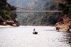
Piyain River in Zero Point Jaflong, Sylhet
Location
Countries India, Bangladesh
District Sylhet
Physical characteristics
Source 
  locationUmgat river of Assam
Mouth  
  location
Surma River
Length145 kilometres (90 mi)

Piyain River a trans-boundary river of India and Bangladesh. [1] It is a tributary of the Surma river, which is originates from the Umngot of Meghalaya . The river enters Bangladesh through Sylhet district.

Contents

The origin and flow

The length of the river is 145 km. [2] Piyain river has emerged from the river om or Umagat river or Assam. [3]

Related Research Articles

<span class="mw-page-title-main">Karnaphuli</span> River in India and Bangladesh

Karnaphuli, or Khawthlangtuipui, is the largest and most important river in Chattogram and the Chattogram Hill Tracts. It is a 667-metre (2,188 ft) wide river in the south-eastern part of Bangladesh. Originating from the Saithah village of Mamit district in Mizoram, India, it flows 270 kilometres (170 mi) southwest through Chattogram Hill Tracts and Chattogram into the Bay of Bengal. Before the Padma, it was the fastest flowing river in Bangladesh. It is said to "represent the drainage system of the whole south-western part of Mizoram." Principal tributaries include the Kawrpui River or Thega River, Tuichawng River and Phairuang River. A large hydroelectric power plant using Karnaphuli river was built in the Kaptai region during the 1960s. The mouth of the river hosts the Port of Chattogram, the largest and busiest seaport of Bangladesh.

Feni River is a river in southeastern Bangladesh and Tripura state of India. It is a trans-boundary river with an ongoing dispute about water rights. The Feni River originates in South Tripura district and flows through Sabroom town and then enters Bangladesh. Muhuri River, also called Little Feni, from Noakhali District joins it near its mouth. The river is navigable by small boats as far as Ramgarh, about 80 kilometres (50 mi) upstream.

<span class="mw-page-title-main">Baral River</span>

Baral river is one of the offshoots of the Ganges, starts its journey at Charghat Upazila of Rajshahi District of Bangladesh. The Baral flows through Natore and Pabna meets with the Gumani River at the east of Bhangura and finally meets with the Hurasagar River after joining with the Karatoya south of Shahjadpur Upazila. The river is approximately 147 kilometres (91 mi) long, and 120 metres (410 ft) wide and 6 metres (20 ft) deep on average. The river receives water from the Ganges only in the monsoon season. But it maintains its flow throughout the year with local runoff water and water from Chalan Beel. Its drainage area is about 230 square kilometres (89 sq mi). Some important places located on the banks of the Baral are: Charghat, Baraigram, Bagatipara, Gurudaspur, Chatmohar, Bhangura and Bera upazilas of Bangladesh. The Baral Bridge is located on this river at Bhangura Upazila.

<span class="mw-page-title-main">Khowai River</span> River in India & Bangladesh

Khowai River is a trans-boundary river that originates in the eastern part of the Atharamura Hills of Tripura in India.

<span class="mw-page-title-main">Manu River (Tripura)</span> River in Tripura, India and Bangladesh

Manu is an Indo-Bangladesh transboundary river that originates below the Kahosib Chura of the Shakhantang Mountains in the Indian state of Tripura, flowing north-east through Kumarghat and Kailasahar, and Passes through the Moulvibazar district of Bangladesh to the Sylhet Plain, later the Dholai River joins Manu and then it flows northwest and meets the Kushiara Manumukh. It is 167 km long, making it the longest river in Tripura. It is located near the town of Manu. The river has a width of 200 meters in the railway bridge area. The area of the basin is 500 square kilometres. The river flows throughout the year.

Hathazari is an upazila of Chattogram District in Chattogram Division, Bangladesh.

<span class="mw-page-title-main">Sonagazi Upazila</span> Upazila in Chittagong Division, Bangladesh

Sonagazi is an upazila (sub-district) of Feni District in the Division of Chittagong, Bangladesh.

Gowainghat is an upazila of Sylhet District in the Division of Sylhet, Bangladesh.

<span class="mw-page-title-main">Companiganj Upazila, Sylhet</span> Place in Sylhet Division

Companiganj is an upazila of Sylhet District in the Division of Sylhet, Bangladesh.

Jaintiapur is an upazila of Sylhet District in the Division of Sylhet, Bangladesh.

Kaliganj is an upazila (sub-district) of Gazipur District in central Bangladesh, part of the Dhaka Division.

Chowgacha is an upazila of Jessore District in the Division of Khulna, Bangladesh.

<span class="mw-page-title-main">Turag River</span> River in Bangladesh

Turag River is the upper tributary of the Buriganga, a major river in Bangladesh. The Turag originates from the Bangshi River, the latter an important tributary of the Dhaleshwari River, flows through Gazipur and joins the Buriganga at Mirpur in Dhaka District. It is navigable by boat all year round.

<span class="mw-page-title-main">Jaflong</span> Hill station

Jaflong is a hill station and tourist destination in the Division of Sylhet, Bangladesh. It is located in Gowainghat Upazila of Sylhet District and situated at the border between Bangladesh and the Indian state of Meghalaya, overshadowed by subtropical mountains and rainforests. It is known for its stone collections and is home of the Khasi tribe.

<span class="mw-page-title-main">Hakaluki Haor</span>

Hakaluki Haor is a marsh wetland ecosystem of north-eastern Bangladesh. It is one of Bangladesh's largest and one of Asia's large marsh wetland resources. Hakaluki Haor is bounded by the Kushiara river as well as a part of the Sonai Bardal river to the north, by the Fenchuganj-Kulaura railway to the west and to the south, and by the Kulaura-Beanibazar road the east. It lies between 24°35’ N to 24°44’ N and 92°00’ E to 92°08’ E.

<span class="mw-page-title-main">Halda River</span>

Halda River is a river in south-eastern Bangladesh. It originates at the Badnatali Hill Ranges in Ramgarh Upazila in the Chittagong Hill Tracts, flows through Fatikchhari Upazila, Bhujpur Thana, Hathazari Upazila, Raozan Upazila and Chandgaon Thana of the Chittagong Metropolitan City, and falls into the Karnaphuli River. The 81-kilometre-long (50 mi) river has a very turbulent tributary, the Dhurung River, which joins Purba Dhalai about 48 kilometres (30 mi) downstream. The river is navigable by big boats 29 km (18 mi) from its mouth up to Nazir Hat, and by small boats 16–24 kilometres (9.9–14.9 mi) further up to Narayanhat. The Halda averages 21 feet (6.4 m) in depth and is 30 feet (9.1 m) at its deepest point.

Shayestaganj, also spelt Shaistaganj, is an upazila (sub-district) of Habiganj District in northeastern Bangladesh, part of the Sylhet Division. There is one Paurasava (Municipality) and three Unions under this Thana. They are: Shaistaganj Paurasava, Shaistaganj Union, Nurpur Union and Brammondura Union.

<span class="mw-page-title-main">Noakhali Zilla School</span> Government school in Bangladesh

Noakhali Zilla School is a boy's high school located in the Maijdee town of Noakhali, Bangladesh. It is one of the oldest schools in the country. The school was established in 1850.(EIIN NUMBER 107540).

<span class="mw-page-title-main">Dhalai River</span> River in Tripura, India and Bangladesh

The Dhalai River a trans-boundary river in India and Bangladesh. It rises in the mountains of the Indian state of Tripura. It enters Kulaura Upazila of Maulvibazar District of Bangladesh. Later it joins Manu River in Rajnagar Upazila. The co-ordinates of Dhalai River at Ambassa are 23.55'128'' N and 91.51'204'' E in degrees minutesseconds(DMS). It originate from Atharamura Hill and is 117 kilometres (73 mi) long. Some of the popular riverside townships of Dhalai River are the towns of Ambassa, Baralutma and Kamalpur.

<span class="mw-page-title-main">Bichnakandi</span> Tourist spot in Sylhet district

Bisnakandi Picnic Point

References

  1. The story of a River of Jaflong in Bangladesh
  2. Masud Hasan Chowdhury (2012), "Piyain River", in Sirajul Islam and Ahmed A. Jamal (ed.), Banglapedia: National Encyclopedia of Bangladesh (Second ed.), Asiatic Society of Bangladesh
  3. Tourist Spot - Piyain River

Coordinates: 24°46′N91°06′E / 24.767°N 91.100°E / 24.767; 91.100