| Economic region [3] | Total area (km2) [4] | Population (2021, thousands) [4] | Population density (2021, people per km2) | Description |
|---|
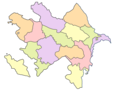
| Baku | 2,140 | 2,300.5 | 1,075 | Includes Baku itself; it is the country's economic centre. Main industries: international trade, oil refining, chemical, machine-building, food, and textiles. [5] The military, high-tech, and information technology industries are also developing. [6] |
| Absheron-Khizi | 3,730 | 578.8 | 155 | Includes the Absheron and Khizi districts and Sumgait city. The main industries are petrochemical, chemical, metallurgy, energy, mechanical and electrical engineering, food, construction, and transport infrastructure. |
| Ganja-Dashkasan | 5,270 | 611.3 | 116 | Includes the Dashkasan, Goranboy, Goygol, and Samukh districts and the cities of Ganja and Naftalan. |
| Shaki-Zagatala | 8,840 | 630.4 | 71 | Includes the Balakan, Qakh, Qabala, Oghuz, Zagatala, and Shaki districts. The main industries are light industry, tourism and food. [7] |
| Lankaran-Astara | 6,070 | 953.6 | 157 | Includes the Astara, Jalilabad, Lerik, Yardimli, Lankaran, and Masally districts. The main industries are food and tourism. |
| Guba-Khachmaz | 6,960 | 558.7 | 80 | Includes the Shabran, Khachmaz, Guba, Qusar, and Siyazan districts. The main industries are agriculture, light industry, tourism, and food. [8] |
| Central Aran | 6,690 | 740 | 111 | Includes the Aghdash, Goychay, Kurdamir, Ujar, Yevlakh, and Zardab districts, and Mingachevir city. [9] |
| Karabakh | 8,990 | 904.5 | 101 | Includes the Agjabadi, Aghdam, Barda, Fuzuli, Khojaly, Khojavend, Shusha, and Tartar districts and Khankendi (Stepanakert) city. |
| East Zangezur | 7,470 | 343.5 | 46 | Includes the Jabrayil, Kalbajar, Qubadli, Lachin, and Zangilan districts. |
| Mountainous Shirvan | 6,130 | 324.8 | 53 | Includes the Agsu, Ismayilli, Gobustan, and Shamakhi districts. The main industries are light industry and food. |
| Nakhchivan | 5,500 | 461.5 | 84 | Includes the whole territory of the Nakhchivan Autonomous Republic. The main industries are light industry, auto, and food. |
| Gazakh-Tovuz | 7,030 | 687.6 | 98 | Includes the Aghstafa, Gadabay, Gazakh, Shamkir, and Tovuz districts. |
| Mil-Mughan | 5,670 | 522.6 | 92 | Includes the Beylagan, Imishli, Saatly, and Sabirabad districts. |
| Shirvan-Salyan | 6,080 | 501.3 | 82 | Includes the Bilasuvar, Hajigabul, Neftchala, and Salyan districts, and Shirvan city. |
| Total | 86,570 | 9,593 | | |
|---|