Related Research Articles

West Midlands is a metropolitan and ceremonial county in the larger West Midlands region of England. A landlocked county, it is bordered by Staffordshire to the north and west, Worcestershire to the south, and is surrounded by Warwickshire to the east. The largest settlement is the city of Birmingham.
The County of the City of Coventry was a county corporate of England which existed between 1451 and 1842.
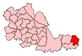
Coventry North East was a constituency represented in the House of Commons of the UK Parliament.
The Meriden Rural District was a rural district of Warwickshire, England, which existed between 1894 and 1974. It was named after the village of Meriden.
Radford is a suburb and electoral ward of Coventry, located approximately 1.5 miles north of Coventry city centre. It is covered by the Coventry North West constituency.

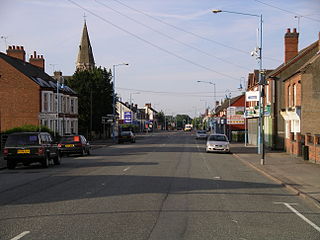
Foleshill is a suburb in the north of Coventry in the West Midlands of England. Longford, Courthouse Green and Rowley Green are to its north and Keresley is to its west. The population of the Ward at the 2021 census was 22,478.

The A444 is a primary road running between Coventry and Burton upon Trent in England, usually referred to as the "A treble four" or "A triple four".

Coventry East is a parliamentary constituency in the city of Coventry in the West Midlands. Having previously existed from 1945 to 1974, the seat was re-established for the 2024 general election in the 2023 Periodic Review of Westminster constituencies, formed primarily from the abolished constituency of Coventry North East.
Coventry North was a parliamentary constituency in the city of Coventry in the West Midlands. It returned one Member of Parliament (MP) to the House of Commons of the Parliament of the United Kingdom, elected by the first past the post system.
Hillfields is a suburb of Coventry in the West Midlands of England. It is situated north of Coventry city centre, and has undergone a series of name changes throughout its history originally called "Harnall" and has seen itself change from a village, to a remote suburb, to a large postwar redevelopment zone.
Hawkesbury or Hawkesbury Village is a village in the Nuneaton and Bedworth district of Warwickshire, England. It lies between Coventry and Bedworth. In 2021 it had a population of 2,290.
Longford is a ward in the north of Coventry, West Midlands, England. The population of the Ward as taken at the 2011 census was 18,538. It is covered by the Coventry North East constituency and bounded by the wards of Holbrooks, Henley, Upper Stoke and Foleshill.

Holbrooks is a residential area of Coventry, West Midlands, England.
Stoke Heath is a residential area of Coventry, West Midlands, England. It is situated approximately 1 mile (1.6 km) to the north east of the city centre. It borders Courthouse Green to the north, Wyken to the east, Foleshill to the west, and Stoke to the south with its western edge demarcated by the A444.
Little Heath is an area of Coventry, in the county of West Midlands, in England. Most of the Little Heath area is in the Longford ward of the city.

Coventry Corporation Tramways operated a tramway service in Coventry, England, between 1912 and 1940.

Stockingford was a railway station serving the Stockingford area of Nuneaton in Warwickshire, England. It was opened by the Midland Railway on the Birmingham-Nuneaton-Leicester Line in 1864, and operated until closure in 1968.

Coventry War Memorial stands at the centre of War Memorial Park, to the south of the city of Coventry in England. The memorial is a tapering tower 87 feet (27 m) high, completed in 1927. It was restored in 2011, and designated as a Grade II* listed building in January 2013. At the same time, the park was itself listed at Grade II, and the gates and gate posts at the park's main entrance were separately Grade II listed.
References
- "Edgwick" in "School Board Schools" (1876) 34 The Builder 960 (30 September 1876)
- "The New Board Schools at Edgwick" in "Foleshill" (1876) 6 The British Architect and Northern Engineer 123 (25 August 1876)
- ↑ Broster, Nicole. "Edgwick Park - Parks and open spaces in Coventry". Coventry City Council.
- ↑ City of Coventry. 1966 Review of the Development Plan: Analysis and Statement. pp 114 and 136.
- ↑ Charles Villiers. Start Again, Britain. Quartet Books. 1984. p 11.
52°25′32″N1°29′25″W / 52.4255°N 1.4904°W
| | This West Midlands location article is a stub. You can help Wikipedia by expanding it. |