Edinglassie (New South Wales)

Last updated

Edinglassie
170 - Edinglassie - PCO Plan Number 170 (5045625p1).jpg
Heritage boundaries
Location710 Denman Road, Muswellbrook, Muswellbrook Shire, New South Wales, Australia
Coordinates 32°18′12″S150°49′44″E / 32.3032°S 150.8290°E / -32.3032; 150.8290
Built18801895
Architect John Horbury Hunt
Architectural style(s) Italianate
Official nameEdinglassie
TypeState heritage (landscape)
Designated2 April 1999
Reference no.170
TypeHomestead Complex
CategoryFarming and Grazing
Australia New South Wales relief location map.png
Red pog.svg
Location of Edinglassie in New South Wales

Edinglassie is a heritage-listed farm and homestead located at 710 Denman Road, Muswellbrook in the Muswellbrook Shire local government area of New South Wales, Australia. It was built from 1880 to 1895. It was added to the New South Wales State Heritage Register on 2 April 1999. [1]

Contents

History

The land on which both Edinglassie and Rous Lench are located was the original Portion 4 of the Parish of Brougham in the County of Durham. This comprised an area of 520 hectares (1,280 acres) the deed of grant for which was issued to George Forbes on 1 August 1839. Like many grants of the period the land had been occupied for many years before it was officially surveyed and the deed grant issued. [1]

A two-storey sandstone house with hipped iron roof of simplified Italianate style built in two stages c.1880, and c.1895, for James White, designed by John Horbury Hunt. [1]

Description

The house is approached through original iron gates and through well kept grounds containing many fine mature trees, including some Queensland species brought from other White family properties. The homestead is set back from the access road, and a substantial line of screening trees fronts the entrance. The siting of the homestead is intrinsic to its significance. [1]

A two-storey sandstone house with hipped iron roof of simplified Italianate style built in two stages c.1880, and c.1895, for James White. Each elevation is asymmetrical about a large full height projecting bay with a continuous single storey verandah (originally two stories to east and south) supported on cast iron columns stamped 'F. REVETT, W. MAITLAND.' [1]

The fourteen principal rooms have a variety of pressed metal ceilings and marble and timber fireplaces whilst the fine joinery throughout is of cedar. All joinery has been sensitively restored. [1]

A timber bridge links across a large trussed roof breezeway to a two-storey service wing containing the original kitchen. Close to the house is the fine stables group of buildings designed by Hunt in timber and built in the 1880s. Although lacking in the more exuberant details characteristic of Hunt's work, these buildings nonetheless form a coherent and impressive whole. Other buildings include a meat house, killing shed and dovecote. [1]

Modifications and dates

The following modifications have been made to the site: [1]

Heritage listing

As at 31 July 2007, the Edinglassie property including the Edinglassie homestead, associated buildings and Rous Lench cottage are closely associated with the earliest European occupation of the area and collectively represent one of the earliest land grants of the initial settlement of the Hunter Valley. [1]

The Edinglassie property demonstrates various phases of human activities such as settlement and clearing, water supply and management, sheep and cattle running, development of specialist cattle breeding activities, recreation, viticulture and horse breeding. [1]

The Edinglassie homestead with its associated outbuildings and Rous Lench cottage are good architectural examples of their type and style. [1]

The Edinglassie property demonstrates an excellent application of the Arcadian design approach to the siting of structures and elements in the landscape which is rare in the region. [1]

The place is also significant because it is associated with George Forbes, the original grantee, who was one of the "gentry" settlers in the early settlement of the area. It is associated with a prominent family, the Whites, a leading pastoral dynasty, who were synonymous with the opening and development of the region. It illustrates the degree of opulence achieved and lifestyles led by the leading pastoral families in the area. It is associated with a significant Australian architect, John Horbury Hunt. [1]

It is a well known landmark, and has provided a community focus over a number of generations form the turn of the 19th century. It has extant and potential intact archaeological evidence capable of helping interpret past occupation and lifestyles of the area. [1] [2]

The siting of the homestead is intrinsic to its significance. [1]

Edinglassie was listed on the New South Wales State Heritage Register on 2 April 1999. [1]

See also

Related Research Articles

<span class="mw-page-title-main">Muswellbrook Shire</span> Local government area in New South Wales, Australia

Muswellbrook Shire is a local government area in the Upper Hunter region of New South Wales, Australia. The Shire is situated adjacent to the New England Highway and the Hunter railway line.

<span class="mw-page-title-main">Christ Church Cathedral, Grafton</span> Church in New South Wales, Australia

Christ Church Cathedral is a heritage-listed Anglican cathedral complex at Duke Street, Grafton, Clarence Valley Council, New South Wales, Australia. The cathedral was designed by John Horbury Hunt and built from 1874 to 1884 by Reynold Brothers (brickwork) and G. J. T. Lawson (woodwork). It is also known as Cathedral Church of Christ the King and Grafton Anglican Cathedral. The property is owned by the Anglican Diocese of Grafton. It was added to the New South Wales State Heritage Register on 14 March 2003.

<span class="mw-page-title-main">The Homestead (Georges Hall)</span> Historic site in New South Wales, Australia

The Homestead is a large, single-storey former homestead and now school at 1a Lionel Street, Georges Hall, New South Wales, Australia, built by David Johnston in 1837. It is listed on the now-defunct Australian Register of the National Estate. It is also known as Georges Hall. The property is owned by Church of the Foursquare Gospel (Aust) Ltd. It was added to the New South Wales State Heritage Register on 2 April 1999.

<i>Camelot, Kirkham</i> Mansion in New South Wales, Australia

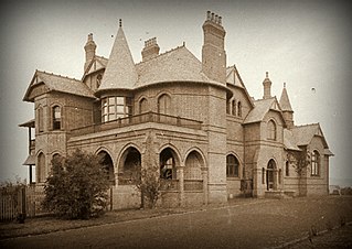
Camelot is a heritage-listed former residence, race horse stud and homestead and now large home located at Kirkham Lane in the south-western Sydney suburb of Narellan in the Camden Council local government area of New South Wales, Australia. It was designed by John Horbury Hunt and built from 1881 to 1888. It is also known as Camelot and Kirkham. It was added to the New South Wales State Heritage Register on 2 April 1999.

<span class="mw-page-title-main">James Cobb White</span> Australian politician

James Cobb White was an Australian grazier and politician, predominantly in New South Wales.

<span class="mw-page-title-main">Lansdowne Park, Goulburn</span> Historic site in New South Wales, Australia

Lansdowne Park is a heritage-listed homestead at Bungonia Road, Goulburn, Goulburn Mulwaree Council, New South Wales, Australia. It was built from 1822 to 1825. It is also known as Lansdowne. It was added to the New South Wales State Heritage Register on 2 April 1999.

<span class="mw-page-title-main">Loxton House</span> Historic site in New South Wales, Australia

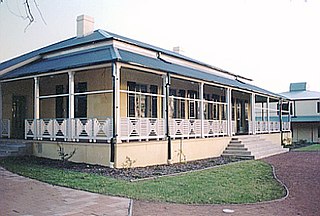
Loxton House is a heritage-listed former residence and now restaurant located at 142–144 Bridge Street, Muswellbrook in the Muswellbrook Shire local government area of New South Wales, Australia. It was built in 1838 and was added to the New South Wales State Heritage Register on 2 April 1999.

<span class="mw-page-title-main">St Alban's Anglican Church</span> Church in New South Wales, Australia

St Alban's Anglican Church is a heritage-listed Anglican church located at Hunter Terrace, Muswellbrook in the Muswellbrook Shire local government area of New South Wales, Australia. It was designed by Sir George Gilbert Scott and built from 1864 to 1869 by Edmund Blacket, supervised by John Horbury Hunt. It is also known as St. Alban's Anglican Church and St Albans Church. The property is owned by the Trustees of the Anglican Diocese of Newcastle. The church was added to the New South Wales State Heritage Register on 2 April 1999.

<span class="mw-page-title-main">Rous Lench, Muswellbrook</span> Historic site in New South Wales, Australia

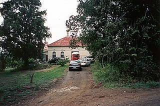
Rous Lench is a heritage-listed farm and homestead located at Denman Road, Muswellbrook in the Muswellbrook Shire local government area of New South Wales, Australia. It was built from 1875 to 1895. It was added to the New South Wales State Heritage Register on 2 April 1999.

<span class="mw-page-title-main">Orielton, Harrington Park</span> Historic site in New South Wales, Australia

Orielton is a heritage-listed former hunting, pleasure garden, farming estate, weekender, cereal cropping, flour mill and pastoral property and now horse agistment and residence located at 181 - 183 Northern Road in the south-western Sydney suburb of Harrington Park in the Camden Council local government area of New South Wales, Australia. It was designed and built from 1815 to 1834. It is also known as Orielton Farm and Orielton Homestead. The property is privately owned. It was added to the New South Wales State Heritage Register on 22 December 2006.

<span class="mw-page-title-main">Oswald Bond Store</span> Historic site in New South Wales, Australia

The Oswald Bond Store is a heritage-listed former wool bond store and now offices at 1–17 Kent Street, in the inner city Sydney suburb of Millers Point in the City of Sydney local government area of New South Wales, Australia. It was designed by A. L. & G. McCredie and built by J. R. Locke. It is also known as Hentsch's Bond Store. It was added to the New South Wales State Heritage Register on 2 April 1999.

<span class="mw-page-title-main">2-4 Trinity Avenue, Millers Point</span> Historic site in New South Wales, Australia

2–4 Trinity Avenue, Dawes Point is a heritage-listed residence at 2–4 Trinity Avenue, in the inner city Sydney suburb of Dawes Point in the City of Sydney local government area of New South Wales, Australia. It was designed by the NSW Government Architect. The property was added to the New South Wales State Heritage Register on 2 April 1999.

<span class="mw-page-title-main">14-22 Trinity Avenue, Millers Point</span> Historic site in New South Wales, Australia

14–22 Trinity Avenue, Millers Point is a heritage-listed residence located at 14–22 Trinity Avenue, in the inner city Sydney suburb of Millers Point in the City of Sydney local government area of New South Wales, Australia. The property was added to the New South Wales State Heritage Register on 2 April 1999.

<span class="mw-page-title-main">24-26 Lower Fort Street, Millers Point</span> Historic site in New South Wales, Australia

24–26 Lower Fort Street, Millers Point are heritage-listed terrace houses located at 24, 26 Lower Fort Street, in the inner city Sydney suburb of Millers Point in the City of Sydney local government area of New South Wales, Australia. The property was added to the New South Wales State Heritage Register on 2 April 1999.

<span class="mw-page-title-main">83-85 Kent Street, Millers Point</span> Historic site in New South Wales, Australia

83–85 Kent Street, Millers Point is a heritage-listed former residence and now boarding house located at 83–85 Kent Street, in the inner city Sydney suburb of Millers Point in the City of Sydney local government area of New South Wales, Australia. The property is privately owned and was added to the New South Wales State Heritage Register on 2 April 1999.

<span class="mw-page-title-main">60-62 Kent Street, Millers Point</span> Historic site in New South Wales, Australia

60–62 Kent Street, Millers Point are heritage-listed terrace houses located at 60–62 Kent Street, in the inner city Sydney suburb of Millers Point in the City of Sydney local government area of New South Wales, Australia. It was added to the New South Wales State Heritage Register on 2 April 1999.

<span class="mw-page-title-main">56-58 Kent Street, Millers Point</span> Historic site in New South Wales, Australia

56–58 Kent Street, Millers Point are heritage-listed terrace houses located at 56–58 Kent Street, in the inner city Sydney suburb of Millers Point in the City of Sydney local government area of New South Wales, Australia. The property was added to the New South Wales State Heritage Register on 2 April 1999.

<span class="mw-page-title-main">28 Kent Street, Millers Point</span> Historic site in New South Wales, Australia

28 Kent Street, Millers Point is a heritage-listed former retail building and now residence located at 28 Kent Street, in the inner city Sydney suburb of Millers Point in the City of Sydney local government area of New South Wales, Australia. The property was added to the New South Wales State Heritage Register on 2 April 1999.

<span class="mw-page-title-main">40-44 Argyle Place, Millers Point</span> Historic site in New South Wales, Australia

40–44 Argyle Place, Millers Point is a row of heritage-listed terrace houses located at 40–44 Argyle Place, in the inner city Sydney suburb of Millers Point, within the City of Sydney local government area of New South Wales, Australia. The property was included in the New South Wales State Heritage Register on 2 April 1999.

<span class="mw-page-title-main">36-38 Argyle Place, Millers Point</span> Historic site in New South Wales, Australia

36–38 Argyle Place, Millers Point are a row of heritage-listed terrace houses located at 36–38 Argyle Place, in the inner city Sydney suburb of Millers Point in the City of Sydney local government area of New South Wales, Australia. The property was added to the New South Wales State Heritage Register on 2 April 1999.

References

  1. 1 2 3 4 5 6 7 8 9 10 11 12 13 14 15 16 17 "Edinglassie". New South Wales State Heritage Register . Department of Planning & Environment. H00170. Retrieved 1 June 2018. CC BY icon.svg Text is licensed by State of New South Wales (Department of Planning and Environment) under CC-BY 4.0 licence .
  2. Tropman & Tropman Architects (1993). Edinglassie & Rous Lench - preliminary Conservation Management Plan. p. 149.

Bibliography

Attribution

CC BY icon-80x15.png This Wikipedia article was originally based on Edinglassie , entry number 00170 in the New South Wales State Heritage Register published by the State of New South Wales (Department of Planning and Environment) 2018 under CC-BY 4.0 licence , accessed on 1 June 2018.