
Muswellbrook is a town in the Upper Hunter Region of New South Wales, Australia, about 243 km (151 mi) north of Sydney and 127 km (79 mi) north-west of Newcastle.
Blackheath railway station is a heritage-listed former railway bridge and now railway station located on the Main Western line in Blackheath in the City of Blue Mountains local government area of New South Wales, Australia. It was designed and built by NSW Government Railways and built from 1897 to 1985. It is also known as the Blackheath Railway Station Group. The property was added to the New South Wales State Heritage Register on 2 April 1999. The station opened on 28 December 1869.

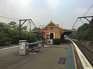
Muswellbrook railway station is a heritage-listed railway station located on the Main Northern line in Muswellbrook, in the Muswellbrook Shire local government area of New South Wales, Australia. The station serves the town of Muswellbrook and was designed by John Whitton, the Chief Engineer of NSW Railways. It is also known as Muswellbrook Railway Station and yard group and Musclebrook Railway Station. The property was added to the New South Wales State Heritage Register on 2 April 1999.

Muswellbrook Shire is a local government area in the Upper Hunter region of New South Wales, Australia. The Shire is situated adjacent to the New England Highway and the Hunter railway line.
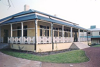
The Homestead is a large, single-storey former homestead and now school at 1a Lionel Street, Georges Hall, New South Wales, Australia, built by David Johnston in 1837. It is listed on the now-defunct Australian Register of the National Estate. It is also known as Georges Hall. The property is owned by Church of the Foursquare Gospel (Aust) Ltd. It was added to the New South Wales State Heritage Register on 2 April 1999.
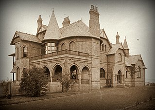
Camelot is a heritage-listed former residence, race horse stud and homestead and now large home located at Kirkham Lane in the outer south-western Sydney suburb of Narellan, New South Wales, Australia. It was designed by John Horbury Hunt and built from 1881 to 1888. It is also known as Camelot and Kirkham. It was added to the New South Wales State Heritage Register on 2 April 1999.

The Howick Street houses are five heritage-listed neighbouring semi-detached houses at 194, 196, 198, 200 and 202 Howick Street, Bathurst, Bathurst Region, New South Wales, Australia. 194, 196 and 198 are separately heritage-listed, while 200 and 202 are listed together. The houses are privately-owned. It is also known as Terrace Cottages. The five houses were all added to the New South Wales State Heritage Register on 2 April 1999.

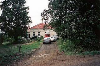
Edinglassie is a heritage-listed farm and homestead located at 710 Denman Road, Muswellbrook in the Muswellbrook Shire local government area of New South Wales, Australia. It was built from 1880 to 1895. It was added to the New South Wales State Heritage Register on 2 April 1999.
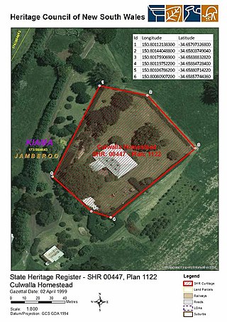
Culwalla Homestead is a heritage-listed former dairy farm and now residence located 2 km east of Jamberoo Main Road, Jamberoo, in the Illawarra region of New South Wales, Australia. It was built in 1858 by James Marks. It was added to the New South Wales State Heritage Register on 2 April 1999.
Arnprior is a heritage-listed homestead and farm at Mayfield Road, Larbert, in the Southern Tablelands region of New South Wales, Australia. It was built from 1827 by William Ryrie. It was added to the New South Wales State Heritage Register on 18 November 1999.
The Kyeemagh Market Gardens are heritage-listed market gardens at Occupation Road, Kyeemagh, Bayside Council, New South Wales, Australia. It was established from 1892. It is also known as Occupation Road Market Gardens, Chinese Market Gardens and Rockdale Market Gardens. It was added to the New South Wales State Heritage Register on 2 April 1999.
Muswellbrook Post Office is a heritage-listed post office at 7 Bridge Street, Muswellbrook, New South Wales, Australia. It was added to the Australian Commonwealth Heritage List on 08 November 2011.

Davisville is a heritage-listed former YWCA women's home, residence and commune and now residence and bed and breakfast at 63-67 Falls Road, Wentworth Falls, City of Blue Mountains, New South Wales, Australia. It was built from 1888 to 1920 by David Davis, Sydney builder. It is also known as Rennie House. It was added to the New South Wales State Heritage Register on 2 April 1999.

Harrington Park is a heritage-listed former race track, rural estate management and alluvial grazing paddocks located at 1 Hickson Circuit in the south-western Sydney suburb of Harrington Park in the Camden Council local government area of New South Wales, Australia. The original designer is unconfirmed, with 1950-60s additions completed by Marcel Weyland. The homestead was built from 1817 to 1827. The property is privately owned and was added to the New South Wales State Heritage Register on 22 December 2006.
Orielton is a heritage-listed former hunting, pleasure garden, farming estate, weekender, cereal cropping, flour mill and pastoral property and now horse agistment and residence located at 181 - 183 Northern Road in the south-western Sydney suburb of Harrington Park in the Camden Council local government area of New South Wales, Australia. It was designed and built from 1815 to 1834. It is also known as Orielton Farm and Orielton Homestead. The property is privately owned. It was added to the New South Wales State Heritage Register on 22 December 2006.

Australiana Pioneer Village is a heritage-listed open-air museum at Rose Street, Wilberforce, New South Wales, an outer suburb of Sydney, Australia. It was built from 1969 to 1970. The property is owned by the Hawkesbury City Council.

75–77 Lower Fort Street is a heritage-listed shop and residence located at 75 and 77 Lower Fort Street, in the inner city Sydney suburb of Millers Point, in the City of Sydney local government area of New South Wales, Australia. It was added to the New South Wales State Heritage Register on 2 April 1999.

44 Kent Street, Millers Point is a heritage-listed terrace house located at 44 Kent Street, in the inner city Sydney suburb of Millers Point in the City of Sydney local government area of New South Wales, Australia. It was added to the New South Wales State Heritage Register on 2 April 1999.

28 Kent Street, Millers Point is a heritage-listed former retail building and now residence located at 28 Kent Street, in the inner city Sydney suburb of Millers Point in the City of Sydney local government area of New South Wales, Australia. The property was added to the New South Wales State Heritage Register on 2 April 1999.

Hadley Park is a heritage-listed former Aboriginal land, farm, dairy and gravel quarry and now unused building at 14-278 Old Castlereagh Road, Castlereagh, City of Penrith, New South Wales, Australia. It was built from 1803 to 1812. It was added to the New South Wales State Heritage Register on 20 April 2018.


