Eggner's Ferry Bridge

Last updated
Eggner's Ferry Bridge
New Eggner's Ferry Bridge.jpg
The new Eggner's Ferry Bridge, viewed from the south in August 2022
Coordinates 36°46′21″N88°07′16″W / 36.772408°N 88.120995°W / 36.772408; -88.120995 Coordinates: 36°46′21″N88°07′16″W / 36.772408°N 88.120995°W / 36.772408; -88.120995
Crosses Kentucky Lake
LocaleUS 68.svgElongated circle 80.svg US 68  / KY 80 in Trigg and Marshall counties, Kentucky, United States
Maintained by Kentucky Transportation Cabinet (KYTC)
Characteristics
Design Tied-arch bridge
Total length3,495 feet (1,065 m)
Longest span550 feet (170 m)
History
OpenedMarch 25, 1932 (1932-03-25) (Original bridge)
April 7, 2016 (2016-04-07) (Current bridge)
ClosedApril 7, 2016 (2016-04-07) (Original bridge); Original structure demolished July 25, 2016
Location
Eggner's Ferry Bridge

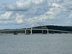
Eggner Ferry Bridge, also known as Eggner's Ferry Bridge, is a four-lane bridge in Trigg and Marshall counties in the U.S. state of Kentucky. The current through-arch bridge opened to traffic on April 7, 2016, replacing a two-lane bowstring truss bridge constructed in 1932. The bridge carries US 68 and Kentucky Route 80 across Kentucky Lake. The main span of the original 1932 bridge collapsed on January 26, 2012 after it was hit by a ship. There were no injuries. The bridge was repaired and reopened to traffic on May 25 of that year. On the morning of July 25, 2016, the middle four spans of the old Eggner's Ferry Bridge were brought down using controlled explosives.

Contents

History

The bridge was built to cross the Tennessee River before Kentucky Lake was planned. The bridge was opened to traffic on March 25, 1932. [1]

On July 10, 1943, officials shut the bridge down for five months to build new pilings and raise the structure to make room for Kentucky Lake. A ferry was established to cross the river while the bridge was closed. Kentucky Governor Simeon S. Willis presided over the re-opening of the bridge in February 1944. [2]

The bridge, plus a sister bridge that crosses nearby Lake Barkley, was slated to be replaced by a tied-arch bridge with four traffic lanes plus a sidewalk and bike path. Construction of the new bridges was initially scheduled to begin in 2011 as part of an upgrade to the existing 68/80 corridor. The project was expected to be completed in late 2017; [3] however, due to damage by a ship strike in January 2012, the timetable was moved forward. [4]

The new bridge opened for traffic on 2 lanes in summer of 2016. The old bridge was closed permanently in May 2016; on July 25, 2016 construction crews used explosives to demolish the original 1932 structure. [5] [6]

January 2012 incident

The original Eggner's Ferry Bridge in February 2012, with the MV Delta Mariner and destroyed span Delta Mariner at Eggner Ferry Bridge collapse site.jpg
The original Eggner's Ferry Bridge in February 2012, with the MV Delta Mariner and destroyed span

A mainspan of the bridge collapsed after being struck by the cargo vessel MV Delta Mariner on January 26, 2012. At least four vehicles were reported to be on the bridge near the time of the collapse. One pickup truck stopped about 5 feet (1.5 m) from the edge of the missing section; the driver reported that two cars had stopped directly behind him, and he saw another car on the opposite side of the missing section. [4] No injuries were reported. [7] [8]

The U.S. Coast Guard reported on January 27 that the Delta Mariner hit the bridge when it tried to pass through what is known as the recreational channel, which has a lower clearance, instead of the shipping channel, which the vessel normally used. [9]

Reports indicate that some of the bridge's navigational lighting was inoperative at the time of the incident. Paducah television station WPSD-TV reported earlier in the week that the bridge was to be reduced to one lane on January 27 for a Kentucky Transportation Cabinet (KYTC) crew to repair the lights. KYTC spokesman Keith Todd stated that the lights facing the MV Delta Mariner were operational, and that the Coast Guard had made the lighting situation known to vessels operating on the waterway. [10]

Kentucky Governor Steve Beshear announced that the state would immediately review all options for restoring the roadway to service. "We are grateful that this wreck caused no injuries or loss of life. Since that bridge carries 2,800 cars every day, we were very fortunate that no one was on the span at that time," said Beshear. "We'll turn our attention to a full inspection of the bridge and determine what steps we can take next to speed up the replacement of that important artery." [11]

An ongoing concern was the economic impact of the loss of the bridge. The collapse had an immediate impact on employees and students at Murray State University who normally crossed the bridge during their commutes. According to university officials, about 270 students who attend classes in Murray, 210 of them attending full-time, live in two counties (Trigg and Christian) for which the most direct route to campus is via the bridge. In addition, at the time of the collapse, the school's nursing students had a clinical placement in Hopkinsville, the county seat of Christian County. These individuals were forced to take a longer route to the university, increasing driving times by approximately an hour, and also increasing their fuel costs to cover the extra distance. University officials worked with students to identify and resolve problems caused by the bridge collapse. [12] [13] [14]

On March 8, 2012, the Kentucky Transportation Cabinet awarded an emergency repair contract to Hall Contracting of Kentucky, Inc. The contract called for repairing and reopening the bridge before the upcoming Memorial Day weekend. The same company had also completed emergency repairs to the Sherman Minton Bridge between New Albany, IN and Louisville, KY on a contract with the Indiana Department of Transportation. [15] The bridge was reopened on May 25, 2012. [16]

Related Research Articles

<span class="mw-page-title-main">Trigg County, Kentucky</span> County in Kentucky, United States

Trigg County is a county located on the far southwestern border of the U.S. state of Kentucky. As of the 2010 census, the population was 14,339. Its county seat is Cadiz. Formed in 1820, the county was named for Stephen Trigg, an officer in the American Revolutionary War who was killed at the Battle of Blue Licks, now in Robertson County, Kentucky. It was a victory for British and allied troops.

<span class="mw-page-title-main">U.S. Route 68</span> Highway in the United States

U.S. Route 68 is a United States highway that runs for 560 miles (900 km) from northwest Ohio to Western Kentucky. The highway's western terminus is at US 62 in Reidland, Kentucky. Its present northern terminus is at Interstate 75 in Findlay, Ohio, though the route once extended as far north as Toledo. US 68 intersects with US 62 three times during its route.

<span class="mw-page-title-main">Kentucky Transportation Cabinet</span> Government agency in Kentucky, United States

The Kentucky Transportation Cabinet (KYTC) is Kentucky's state-funded agency charged with building and maintaining federal highways and Kentucky state highways, as well as regulating other transportation related issues.

<span class="mw-page-title-main">WPSD-TV</span> NBC affiliate in Paducah, Kentucky

WPSD-TV is a television station licensed to Paducah, Kentucky, United States, serving as the NBC affiliate for Western Kentucky's Jackson Purchase region, Southern Illinois, the Missouri Bootheel, and northwest Tennessee. Owned by locally based Paxton Media Group, the station maintains studios on Television Lane in Paducah, and its transmitter is located at Monkey's Eyebrow, Kentucky.

<span class="mw-page-title-main">Kentucky Route 80</span> Highway in Kentucky

Kentucky Route 80 (KY 80) is a 483.55-mile-long (778.20 km) state highway in the southern part of the U.S. state of Kentucky. The route originates on the state's western border at Columbus in Hickman County, and stretches across the southern portion of the state, terminating southeast of Elkhorn City on the Virginia state line. It is the longest Kentucky State Highway, though the official distance as listed in route logs is much less due to multiple concurrencies with U.S. Route 68 (US 68) and U.S. Route 23.

<span class="mw-page-title-main">Western Kentucky Parkway</span> Highway in Kentucky

The Wendell H. Ford Western Kentucky Parkway is a 98.5-mile-long (158.5 km) controlled-access highway running from Elizabethtown, Kentucky to near Nortonville, Kentucky. It intersects with Interstate 65 (I-65) at its eastern terminus, and I-69 at its western terminus. It is one of seven highways that are part of the Kentucky parkway system. The road was renamed for Wendell H. Ford, a former Kentucky governor and United States senator, in 1998. Previously, it was simply the Western Kentucky Parkway, and often called "the WK Parkway" or "the WK" because of the acronym once used on its signs. The parkway carries the unsigned designation Kentucky Route 9001 for its entire length.

<span class="mw-page-title-main">Sherman Minton Bridge</span> Double-deck through arch bridge spanning the Ohio River at Louisville, carrying I-64

The Sherman Minton Bridge is a double-deck through arch bridge spanning the Ohio River, carrying I-64 and US 150 over the river between Kentucky and Indiana. The bridge connects the west side of Louisville, Kentucky to downtown New Albany, Indiana.

<span class="mw-page-title-main">Hal Rogers Parkway</span> Highway in Kentucky

The Hal Rogers Parkway, formerly named the Daniel Boone Parkway, connects Somerset and Hazard in southeastern Kentucky. This toll road opened in November 1971, and the tolls were removed June 1, 2003. The original extent of the highway was to be 65.70 miles (105.73 km) with that mileage to have been included with an unconstructed limited-access London bypass and what is east of this area. The original portion of the road is designated unsigned Kentucky Route 9006. An extension of the Hal Rogers Parkway name west along Kentucky Route 80 (KY 80) to U.S. Route 27 (US 27) in Somerset was made in 2015 bringing the total mileage to 91.135 miles (146.668 km).

<span class="mw-page-title-main">Bert T. Combs Mountain Parkway</span>

The Bert T. Combs Mountain Parkway, commonly known as the Mountain Parkway, is a freeway in eastern Kentucky. The route runs from Interstate 64 just east of Winchester southeast for 75.627 miles (121.710 km) to a junction with U.S. Route 460 near Salyersville. The first 46 miles (74 km), beginning at the western terminus in Winchester is a four-lane limited access highway with only minor design standard differences from an Interstate Highway, while the remainder is a limited access Super two highway.

<span class="mw-page-title-main">Kenlake State Resort Park</span> Park on the western shore of Kentucky Lake

Kenlake State Resort Park is a park located on the western shore of Kentucky Lake. The park's main entrance and most of its facilities are located in Marshall County; the park also extends into Calloway County. The mailing address of the park is Hardin, Kentucky; however, it is located much closer to the unincorporated community of Aurora, Kentucky. The nearest town of substantial size is Murray. The park encompasses 1,795 acres (726 ha) of land, 160,300 acres (64,900 ha) of water, and features climate-controlled indoor tennis courts. It was Kentucky's first state resort park. Along with Lake Barkley State Resort Park and Kentucky Dam Village State Resort Park, Kenlake State Resort Park is part of the Land Between the Lakes National Recreation Area, originally organized by the Great Depression–era Tennessee Valley Authority (TVA).

<span class="mw-page-title-main">Kentucky Route 39</span>

Kentucky Route 39 is a state highway in the U.S. state of Kentucky. The route, part of the State Secondary System, exists in two segments, separated at the Madison-Jessamine county line by the Kentucky River. While there is a boat ramp on each side, there is no bridge or ferry carrying vehicular traffic across the waterway. The southernmost terminus of the route is at Kentucky Route 1247 in Somerset. The northernmost terminus is at U.S. Route 27 Business and Kentucky Route 29 in Nicholasville.

<span class="mw-page-title-main">Interstate 69 in Kentucky</span>

Interstate 69 (I-69) in the US state of Kentucky is a 148.1-mile-long (238.3 km) freeway running from Fulton to Henderson. The route makes use of the entirety of the former Purchase Parkway and existing portions of I-24, the Western Kentucky Parkway, and the Pennyrile Parkway. Eventually, I-69 will leave the former Pennyrile Parkway just south of the Audubon Parkway interchange or remain on its current alignment and travel through Henderson on U.S. Route 41 (US 41) north into Indiana. The proposed route for the remainder of I-69 in Kentucky travels about 10 miles (16 km) to utilize an as-of-yet-unbuilt bridge into Indiana.

<span class="mw-page-title-main">Interstate 65 in Kentucky</span> Interstate Highway in Kentucky, United States

Interstate 65 (I-65) enters the US state of Kentucky five miles (8.0 km) south of Franklin. It passes by the major cities of Bowling Green, Elizabethtown, and Louisville before exiting the state.

<span class="mw-page-title-main">Kentucky Route 259</span>

Kentucky Route 259 is a 95.91-mile-long (154.35 km) state highway that traverses five counties in west-central Kentucky.

MS <i>Star Clipper</i>

MS Star Clipper was a Norwegian-owned bulk carrier built by Kockums in Malmö, Sweden in 1968. In 1981 she was sold and her name changed to Star Lanao. She was scrapped in India in 1986.

<span class="mw-page-title-main">U.S. Route 231 in Kentucky</span> Section of U.S. Highway in Kentucky

U.S. Route 231 in Kentucky runs 86.465 miles (139.152 km) from the Tennessee state line near Adolphus to the William H. Natcher Bridge on the Ohio River near Rockport, Indiana. It crosses the state mainly in the west-central region, traversing Allen, Warren, Butler, Ohio, and Daviess Counties.

The Interstate 69 Ohio River Crossing is a proposed bridge to carry the planned Interstate 69 (I-69) extension over the Ohio River between Evansville, Indiana, and Henderson, Kentucky. The bridge and its approach roadways make up a portion of Segment of Independent Utility 4 of the I-69 corridor from Michigan to Texas. It will be built approximately three miles (4.8 km) upstream of the existing Bi-State Vietnam Gold Star Bridges carrying U.S. Route 41 (US 41), at a point just downstream from where the Green River flows into the Ohio.

RS <i>RocketShip</i>

R/S RocketShip, formerly M/V Delta Mariner, is a cargo ship operated by Keystone Shipping Company for United Launch Alliance (ULA). Her primary role is transporting components for the ULA Atlas V, Delta IV and Vulcan rockets from the manufacturer, located in Decatur, Alabama, to launch facilities at Cape Canaveral Space Force Station in Florida and Vandenberg Space Force Base in California.

McCracken County High School is a public secondary school located west of Paducah, Kentucky that opened on August 9, 2013. Operated by the McCracken County Public Schools district, it consolidates that district's three former high schools—Heath, Lone Oak, and Reidland. Before ground was broken for the new school in June 2010, the school's nickname of Mustangs and colors of crimson, black, and white had been finalized. The school opened with an enrollment of slightly under 1,900.

Lake Barkley Bridge is a four-lane basket handle tied-arch bridge in western Kentucky carrying US 68, Kentucky Route 80, and a multi-use path across Lake Barkley, permitting access from the east to Land Between the Lakes National Recreation Area. It is illuminated with LED lights.

References

  1. Harper, Thomas D. (2010). Trigg County. Images of America. Charleston, South Carolina: Arcadia Publishing. p. 9. ISBN   978-0-7385-8725-7.
  2. "Eggners Ferry Bridge Ribbon Cutting". Explorekentuckylake.com. 1932-03-25. Retrieved 2012-01-27.
  3. "Governor Beshear unveils design for US 68 lakes bridges" (Press release). Kentucky Transportation Cabinet. 2009-07-14. Archived from the original on 2010-01-08. Retrieved 2009-12-29.
  4. 1 2 Kenning, Chris (January 28, 2012). "Ship in wrong channel tears through Kentucky Lake bridge, officials say". The Courier-Journal . Retrieved January 30, 2012.
  5. "Old Eggners Ferry Bridge slated for demolition". WPSD TV-6 Paducah. 2016-06-20. Retrieved 2016-06-30.
  6. Crews demolish Old Eggners Ferry bridge in KY, WSMV-TV, July 26, 2016.
  7. "Eggners Ferry Bridge collapses after barge strike". wpsdlocal6.com. WPSD-TV, Paducah, Ky. Archived from the original on 9 February 2013. Retrieved 27 January 2012.
  8. "Eggners Ferry Bridge collapses". wave3.com. WAVE-3, Louisville, Ky. Archived from the original on 28 January 2012. Retrieved 27 January 2012.
  9. "Coast Guard Update on Eggner's Ferry Bridge Accident". wkdzradio.com. WKDZ Radio, Cadiz, Ky. Archived from the original on 30 January 2012. Retrieved 27 January 2012.
  10. "Keith Todd Interview". wkdzradio.com. WKDZ Radio, Cadiz, Ky. Archived from the original on 30 January 2012. Retrieved 27 January 2012.
  11. "Gov. Beshear Directs Immediate Development of Options". thefrontblog.wordpress.com. WKMS Radio, Murray, Ky. Retrieved 27 January 2012.
  12. Berry, Tom (February 3, 2012). "EDC discusses bridge collapse impact". The Ledger and Times. Murray, Kentucky . Retrieved February 9, 2012.
  13. Ramsey, Austin (February 2, 2012). "State evaluates damages, options". The Murray State News. Murray, Kentucky. Archived from the original on February 13, 2012. Retrieved February 9, 2012.
  14. Anderson, Meghann (February 2, 2012). "Detour adds travel time for commuting students, employees". The Murray State News. Murray, Kentucky. Archived from the original on March 6, 2016. Retrieved February 9, 2012.
  15. Bailey, Philip (March 8, 2012). "Eggners Ferry Bridge To Be Repaired By Memorial Day, Says Beshear". WFPL News. Louisville, Kentucky. Retrieved March 8, 2012.[ permanent dead link ]
  16. Embers, Jasmin (May 25, 2012). "Eggner's Ferry Bridge officially reopened". WFIE . Evansville IN. Retrieved 2012-06-19.