Vanylven is a municipality in Møre og Romsdal county, Norway. It is part of the Sunnmøre region. The administrative centre is the village of Fiskåbygd. Other villages in the municipality include Sandnes, Åheim, Åram, Rovdane, Eidså, Slagnes, and Myklebost.

Rauma is a municipality in Møre og Romsdal county, Norway. It is part of the traditional district of Romsdal. The administrative centre is the town of Åndalsnes. Other settlements in Rauma include the villages of Vågstranda, Måndalen, Innfjorden, Veblungsnes, Verma, Isfjorden, Eidsbygda, Rødven, Åfarnes, and Mittet. Most settlement in the municipality is located along the fjords and in the Romsdalen valley.

Eide is a municipality in Møre og Romsdal county, Norway. It is part of the region of Nordmøre. It is located on the Romsdal peninsula, along the Kornstadfjorden and the Kvernesfjorden. The administrative centre of the municipality is the village of Eide. Other villages include Lyngstad, Vevang, and Visnes.

Hornindal is a municipality in the county of Sogn og Fjordane, Norway. It is located in the traditional district of Nordfjord. The administrative centre of the municipality is the village of Grodås. The municipality sits at the eastern end of the lake Hornindalsvatnet, the deepest lake in Northern Europe. The rest of the lake lies inside neighboring Eid Municipality.

Eid is a municipality in the county of Sogn og Fjordane, Norway. It is located in the traditional district of Nordfjord. The village of Nordfjordeid is the administrative center of the municipality. Other larger villages in Eid include Mogrenda, Stårheim, Haugen, Kjølsdalen, Heggjabygda, and Lote
Hornindalsvatnet is Norway's and Europe's deepest lake, officially measured to a depth of 514 metres (1,686 ft). Its surface is 53 metres (174 ft) above sea level, which means that its bottom is 461 metres (1,512 ft) below sea level. The village of Grodås lies at the eastern end of the lake in Hornindal Municipality and the village of Mogrenda is located on the western end of the lake in Eid Municipality. The European route E39 highway runs near the lake. The village of Heggjabygda and Heggjabygda Church lie on the northern shore of the lake.

Rødven Stave Church is a stave church in Rauma Municipality in Møre og Romsdal county, Norway. It is located in the village of Rødven. The church is part of the Eid og Holm parish in the Indre Romsdal deanery in the Diocese of Møre.

Austnes is a village in Haram Municipality in Møre og Romsdal county, Norway. It is located on the southeast side of the island of Haramsøya, about 12 kilometres (7.5 mi) southwest of the village of Longva via the Ullasund Bridge. The Ulla lighthouse is located about 7 kilometres (4.3 mi) to the north of Austnes. The historic Haram Church is located in Austnes.

Eidsvåg is a village in Nesset Municipality in Møre og Romsdal county, Norway. It is the administrative centre of the municipality. Eidsvåg is located at the end of the Langfjorden on the isthmus connecting the Romsdal peninsula to the Norwegian mainland. It is located about 8.5 kilometres (5.3 mi) southwest of the village of Raudsand, about 20 kilometres (12 mi) north of the village of Eresfjord, and 9 kilometres (5.6 mi) north of the village of Boggestranda. Nesset Church is located in this village.
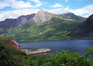
Fiskåbygd or Fiskå is a coastal village that is also the administrative centre of Vanylven Municipality in Møre og Romsdal county, Norway. The village is located about 100 kilometres (62 mi) southwest of the city of Ålesund, about 12 kilometres (7.5 mi) east of the village of Myklebost, and about 30 kilometres (19 mi) southwest of the village of Rovdane. Fiskåbygd lies along the shores of the Vanylvsfjorden, east of the Stadlandet peninsula in Selje Municipality.
Voll is a former municipality in Møre og Romsdal county, Norway. The municipality existed from 1874 until 1964. The 260-square-kilometre (100 sq mi) municipality encompassed the Måndalen and Innfjorden valleys west of the Romsdalsfjorden in the west-central part of the present-day Rauma Municipality. The administrative centre of the village was the village of Voll which is also where the main Voll Church is located.
Eid is a former municipality in Møre og Romsdal county, Norway. It was located in the north-central part of the present-day Rauma Municipality. The municipality was only 36 square kilometres (14 sq mi), along the Romsdalsfjorden. The municipality included the village area of Eidsbygda and extended to the southeast to the coast of the Isfjorden.
Hen is a former municipality in Møre og Romsdal county, Norway. The 245-square-kilometre (95 sq mi) municipality existed from 1902 until 1964, and it encompassed the valleys extending to the south and east of the Isfjorden in the northeastern part of the present-day Rauma Municipality. The administrative center of Hen was the village of Isfjorden. The area of Hen Municipality is still a parish within the municipality of Rauma. The parish has one church, Hen Church, located in Isfjorden.
Eid og Voll is a former municipality in Møre og Romsdal county, Norway. The municipality encompassed most of the northwestern part of the present-day Rauma Municipality from 1840 until 1874. The municipality including the villages of Voll, Innfjorden, and Eidsbygda.
Nedre Frei is a village in Kristiansund Municipality in Møre og Romsdal county, Norway. The village is located along the Freifjorden on the southern part of the island of Frei. The village sits about 8 kilometres (5.0 mi) south of the village of Rensvik and about 6 kilometres (3.7 mi) southwest of the village of Kvalvåg. Nedre Frei is the site of Frei Church, the main church for the island.

Eide is the administrative centre of Eide Municipality in Møre og Romsdal county, Norway, where it sits on the Romsdal Peninsula at the intersection of the Kornstadfjorden and Kvernesfjorden.

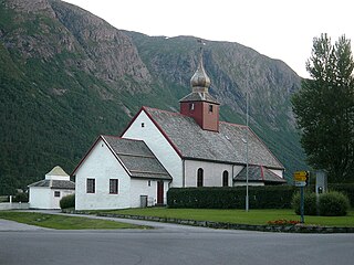
Eid Church is a parish church in Rauma Municipality in Møre og Romsdal county, Norway. It is located in the village of Eidsbygda. The church is part of the Eid og Holm parish in the Indre Romsdal deanery in the Diocese of Møre. The white, wooden church was built in 1797 to replace an older church on the same site. The present church has been significantly renovated twice and it now seats about 200 people.

Rødven Church is a parish church in Rauma Municipality in Møre og Romsdal county, Norway. It is located in the village of Rødven. The church is part of the Eid og Holm parish in the Indre Romsdal deanery in the Diocese of Møre. The red, wooden church was built by the architect Jens Zetlitz Monrad Kielland in 1907 and the church seats about 120 people. The church was built to replace the historic Rødven Stave Church, which sits just across the road.
Rødven is a village in Rauma Municipality in Møre og Romsdal county, Norway. The village is located along the Rødvenfjorden, just south of where the fjord empties into Romsdal Fjord. The village of Eidsbygda lies about 5 kilometres (3.1 mi) south of Rødven. The village is notable for the 12th century Rødven Stave Church. The church is now a museum and the much newer Rødven Church sits across the road from the historic stave church.

Kjølsdalen is a village in Eid in Sogn og Fjordane county, Norway. The village is located on the northern shore of the Nordfjorden, about 8 kilometres (5.0 mi) west of the village of Stårheim and about 12 kilometres (7.5 mi) east of the village of Bryggja. The village of Davik lies about 5 kilometres (3.1 mi) across the fjord from Kjølsdalen. The village is named after the Kjølsdalen valley in which it is located.


