
The Alpine region of Switzerland, conventionally referred to as the Swiss Alps, represents a major natural feature of the country and is, along with the Swiss Plateau and the Swiss portion of the Jura Mountains, one of its three main physiographic regions. The Swiss Alps extend over both the Western Alps and the Eastern Alps, encompassing an area sometimes called Central Alps. While the northern ranges from the Bernese Alps to the Appenzell Alps are entirely in Switzerland, the southern ranges from the Mont Blanc massif to the Bernina massif are shared with other countries such as France, Italy, Austria and Liechtenstein.

The Jungfrau Railway is a mountain rack railway in the Bernese Alps, Switzerland, connecting Kleine Scheidegg in the Bernese Oberland to the Jungfraujoch, across the Valais border. It is the highest railway in Switzerland and Europe, running 9 kilometres (5.6 mi) from the station of Kleine Scheidegg to the Jungfraujoch, well above the perennial snow line. As a consequence, the railway runs essentially within the Jungfrau Tunnel, built into the neighbouring Eiger and Mönch, to protect the line from snow and extreme weather.

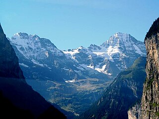
The Jungfrau, at 4,158 meters (13,642 ft) is one of the main summits of the Bernese Alps, located between the northern canton of Bern and the southern canton of Valais, halfway between Interlaken and Fiesch. Together with the Eiger and Mönch, the Jungfrau forms a massive wall of mountains overlooking the Bernese Oberland and the Swiss Plateau, one of the most distinctive sights of the Swiss Alps.

Lauterbrunnen is a village and municipality in the Interlaken-Oberhasli administrative district in the canton of Bern in Switzerland. The municipality comprises the other villages of Wengen, Mürren, Gimmelwald, Stechelberg, and Isenfluh, as well as several other hamlets. The population of the village of Lauterbrunnen is less than that of Wengen, but larger than that of the others.

The Eiger is a 3,967-metre (13,015 ft) mountain of the Bernese Alps, overlooking Grindelwald and Lauterbrunnen in the Bernese Oberland of Switzerland, just north of the main watershed and border with Valais. It is the easternmost peak of a ridge crest that extends across the Mönch to the Jungfrau at 4,158 m (13,642 ft), constituting one of the most emblematic sights of the Swiss Alps. While the northern side of the mountain rises more than 3,000 m (10,000 ft) above the two valleys of Grindelwald and Lauterbrunnen, the southern side faces the large glaciers of the Jungfrau-Aletsch area, the most glaciated region in the Alps. The most notable feature of the Eiger is its nearly 1,800-metre-high (5,900 ft) north face of rock and ice, named Eiger-Nordwand, Eigerwand or just Nordwand, which is the biggest north face in the Alps. This substantial face towers over the resort of Kleine Scheidegg at its base, on the eponymous pass connecting the two valleys.

Grindelwald is a village and municipality in the Interlaken-Oberhasli administrative district in the canton of Berne. In addition to the village of Grindelwald, the municipality also includes the settlements of Alpiglen, Burglauenen, Grund, Itramen, Mühlebach, Schwendi, Tschingelberg and Wargistal.

The Lauterbrunnen–Mürren Mountain Railway is a hybrid transport system in the Bernese Oberland area of Switzerland, which connects the villages of Lauterbrunnen and Mürren. The system consists of a connected aerial cableway, also known as the Grütschalpbahn, and an adhesion worked mountain railway. The cableway replaced a funicular, on the same route, in 2010.

The Kleine Scheidegg is a mountain pass at an elevation of 2,061 m (6,762 ft), situated below and between the Eiger and Lauberhorn peaks in the Bernese Oberland region of Switzerland. The name means "minor watershed", as it only divides the two arms of the Lütschine river, both converging at Zweilütschinen, while the nearby Grosse Scheidegg divides the Lütschine from the Rychenbach stream.

The Jungfraujoch is a saddle connecting two major 4000ers of the Bernese Alps: the Jungfrau and the Mönch. It lies at an elevation of 3,463 metres (11,362 ft) above sea level and is directly overlooked by the rocky prominence of the Sphinx. The Jungfraujoch is a glacier saddle, on the upper snows of the Aletsch Glacier, and part of the Jungfrau-Aletsch area, situated on the boundary between the cantons of Bern and Valais, halfway between Interlaken and Fiesch.

The Jungfrau Marathon is one of the best known mountain marathons in the world, in full view of the famous Eiger, Mönch, and Jungfrau mountains in the Bernese Oberland area of the Swiss Alps.
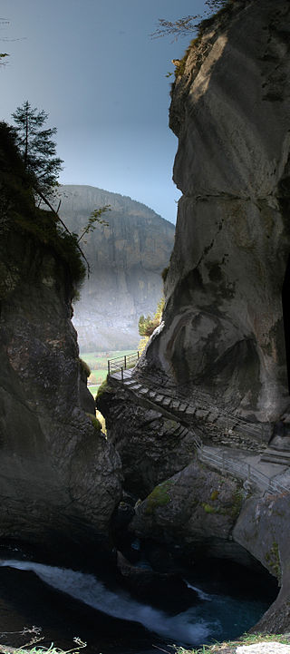
The Trümmelbach Falls in Bernese Oberland, Switzerland, are a series of ten glacier-fed waterfalls inside the mountain made accessible by the tunnel lift, stairs, and illumination.
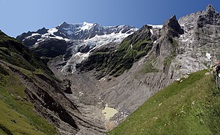
The Lower Grindelwald Glacier is a Glacier in the Swiss Bernese Alps, situated to the south-east of Grindelwald. It starts below the Agassizhorn and the Strahlegghörner and is connected with the Finsteraar Glacier via the Finsteraarjoch.
The Lauterbrunnen Wall is a term used in the English-speaking mountaineering world to refer to a north-west-facing mountain wall in the Bernese Alps in Switzerland. It runs for 8 kilometres from the Gletscherhorn in the east, through the Ebnefluh,, the Mittaghorn (3,897m) and the Grosshorn, to the Breithorn in the west, where the wall comes to an end at the col which separates it from the Tschingelhorn. The Wall is named after the village of Lauterbrunnen, which lies to the north.

Kleine Scheidegg is a railway station and hub that is situated on the summit of Kleine Scheidegg, a mountain pass in the Bernese Oberland region of Switzerland. The pass, located between the Lauberhorn and the Eiger's ridge, houses a complex of hotels and railway buildings. Administratively, the station is in the municipality of Lauterbrunnen in the canton of Bern, a few metres from the border with the municipality of Grindelwald.
The Otemma Glacier is a 7.7 km (4.8 mi) long glacier (2005) situated in the Pennine Alps in the canton of Valais in Switzerland. In 1973 it had a length of 8.7 km (5.4 mi), and an area of 17.5 km2 (6.8 sq mi) but, like most other alpine glaciers, is known to be receding. By 2010 it had receded a further 1.2 km (0.75 mi) from its 1973 position. In summer 2018, the snout zone (terminus) of the glacier collapsed.

The Kander Neve is a 6.6 km (4.1 mi) long glacier (2005) of the Bernese Alps, situated south of Kandersteg in the canton of Bern. The glacier lies at the upper end of the Gasterental, at the foot of the Blüemlisalp and the Tschingelhorn. It borders the valley of Lauterbrunnen on the east and the canton of Valais on the south (Petersgrat). In 1973 it had an area of 13.9 km2 (5.4 sq mi).
The Limmern Glacier is a glacier situated in the Glarus Alps in the canton of Glarus in Switzerland. The glacier is situated below the mountains of Bifertenstock, to the south, and Schiben, to the north. Meltwater from the glacier flows eastwards into the Limmernsee and thence north into the Linth river.

Eigergletscher is a railway station in the municipality of Lauterbrunnen in the canton of Bern. The station is served by trains of the Jungfrau railway, which run to the Jungfraujoch from Kleine Scheidegg, where they connect with services from Interlaken, Lauterbrunnen, Wengen and Grindelwald via the Bernese Oberland railway and the Wengernalp railway.

Jungfraujoch is an underground railway station situated near the Jungfraujoch, in the canton of Valais, a few metres from the border with the canton of Bern. At 3,454 metres (11,332 ft) above sea level, it is the terminus of the Jungfrau Railway and the highest railway station in Switzerland and Europe. The Jungfrau Railway runs from Kleine Scheidegg in the Bernese Oberland, through the Jungfrau Tunnel and crosses the border between the two cantons shortly before the terminus.

The Jungfrau-Aletsch protected area is located in south-western Switzerland between the cantons of Bern and Valais. It is a mountainous region in the easternmost side of the Bernese Alps, containing the northern wall of Jungfrau and Eiger, and the largest glaciated area in western Eurasia, comprising the Aletsch Glacier. The Jungfrau-Aletsch protected area is the first World Natural Heritage site in the Alps; it was inscribed in 2001.
