
Geologically, a fjord or fiord is a long, narrow inlet with steep sides or cliffs, created by a glacier. There are many fjords on the coasts of Alaska, Antarctica, British Columbia, Chile, Greenland, the Faroe Islands, Iceland, Kamchatka, the Kerguelen Islands, New Zealand, Norway, Novaya Zemlya, Labrador, Nunavut, Newfoundland, Quebec, Scotland, South Georgia Island, and Washington state. Norway's coastline is estimated at 29,000 kilometres (18,000 mi) with nearly 1,200 fjords, but only 2,500 kilometres (1,600 mi) when fjords are excluded.

Ulvik is a municipality in Hordaland county, Norway. The municipality stretches from the Hardangerfjord to the mountains that reach 1,800 metres (5,900 ft) above sea level. The administrative centre of the municipality is the village of Ulvik. The villages of Osa and Finse are also located in Ulvik municipality.
Eidfjordvatnet is a moraine-dammed lake in the municipality of Eidfjord in Hordaland county, Norway. The 3.55-square-kilometre (1.37 sq mi) lake is located immediately southeast of the village of Eidfjord. The village of Øvre Eidfjord lies on the southern shore of the lake. Norwegian National Road 7 runs along the western shore of the lake. The water enters the lake through the Bjoreio and Veig rivers, and the water empties from the lake through the Eio River.
Nordmannslågen is a lake in the municipality of Eidfjord in Hordaland county, Norway. At 11.09 square kilometres (4.28 sq mi), it is the largest lake in Hordaland county. The lake lies on the great Hardangervidda plateau in the central part of the Hardangervidda National Park. The lake lies about 35 kilometres (22 mi) southeast of the village of Eidfjord and about 50 kilometres (31 mi) northeast of the town of Odda. The lake is part of the headwaters of the river Numedalslågen.
Halnefjorden is a large lake on the border of Hordaland and Buskerud counties in Norway. It is located in the municipalities of Hol and Nore og Uvdal in Buskerud county and in Eidfjord municipality in Hordaland county. At 13.61 square kilometres (5.25 sq mi), it is among the largest lakes located on the vast Hardangervidda plateau. The Norwegian National Road 7 runs along the northern shore of the lake, and that is the only road access to the lake. The lake is one of the headwaters of the river Numedalslågen.
Skaupsjøen is a lake in the municipalities of Eidfjord in Hordaland county and Nore og Uvdal in Buskerud county, Norway. The 2.88-square-kilometre (1.11 sq mi) lake lies just north of the Hardangervidda National Park on the vast Hardangervidda plateau. The lake outflows to the river Skaupa, which flows into the larger lake Halnefjorden to the northeast. The nearest road access is the Norwegian National Road 7, which passes about 5 kilometres (3.1 mi) northwest of the lake.
Sysenvatnet is a lake in the municipality of Eidfjord in Hordaland county, Norway. The 10.24-square-kilometre (3.95 sq mi) lake lies at the north end of the Sysendalen valley, about 8 kilometres (5.0 mi) east of the famous Vøringfossen waterfall. The lake is dammed on the south end by a large stone embankment, and the lake is used as the main reservoir for the Sima Hydroelectric Power Station. The Sysen Dam can easily be seen from Norwegian National Road 7, which runs near the southern shore of the lake.

Eidfjord is the administrative centre of Eidfjord municipality in Hordaland county, Norway. The village is located on the shore of the Eid Fjord, an inner branch of the large Hardangerfjorden. The village sits about 15 kilometres (9.3 mi) east of the Hardanger Bridge along the Norwegian National Road 7.

Norwegian National Road 7 is a national road in Norway which runs from the town of Hønefoss in Buskerud county to the village of Granvin in Hordaland county. The route is 387.6 kilometres (240.8 mi) long and runs east–west through Buskerud and Hordaland counties over the vast Hardangervidda plateau.

The Granvin Fjord is an arm of the Hardanger Fjord in the municipalities of Granvin and Ullensvang in Hordaland county, Norway. The fjord is about 10 kilometers (6.2 mi) long and its width is mostly less than 1 kilometer (0.62 mi). It has its inlet at the part of the Hardanger Fjord known as the Inner Samla Fjord between two small peninsulas: Furenes by the village of Tjoflot on the east side and Håstabbenes on the west side. From there, the fjord runs in a northeast direction to the village of Granvin at the head of the fjord. The fjord has steep sides and is bordered by mountains up to 1,200 meters (3,900 ft) high.

The Eid Fjord is the innermost part of the Hardanger Fjord in Norway. It extends 29 kilometers (18 mi) eastwards from the Utne Fjord and Sørfjorden. The Eid Fjord lies in the municipalities of Ullensvang, Ulvik, and Eidfjord in Hordaland county.

Brimnes is a small village in the municipality of Eidfjord in Hordaland county, Norway.

The Simadal Fjord is a branch of the Eid Fjord in the municipality of Eidfjord in Hordaland, Norway. The Simadal Fjord is the innermost branch of the Hardanger Fjord. It is 5 kilometers (3.1 mi) long and extends east from its mouth between Blurnes and Eikenes to the head of the fjord at the Sima Valley.

The Sima Valley is a river valley in the municipality of Eidfjord in Hordaland county, Norway. The 8-kilometre (5.0 mi) long valley begins below Lake Rembesdal, with an elevation of 905 meters (2,969 ft), which is one of the sources of the Sima River. The valley then runs west along the river to the Sima Hydroelectric Power Station at the head of the Simadal Fjord, where the river empties into the fjord. Norwegian County Road 103 runs through part of the valley and then continues along the south side of the fjord.
The Sima is a river in the municipality of Eidfjord in Hordaland, Norway. The river is 29.64 kilometers (18.42 mi) long, and it has a drainage basin of 125 square kilometers (48 sq mi) and an average discharge of 8.86 cubic meters per second (313 cu ft/s).
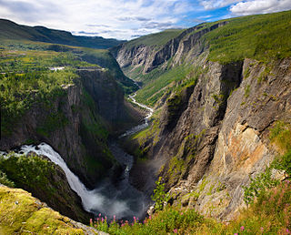
The Bjoreio, also known as the Bjoreia, is a river in the municipality of Eidfjord in Hordaland, Norway. The river is 72 kilometers (45 mi) long, and it has a drainage basin of 627 square kilometers (242 sq mi). Its natural average discharge is 25.2 cubic meters per second (890 cu ft/s), but this is considerably less today because of hydroelectric infrastructure along the watercourse.

The Veig is a river in the municipalities of Eidfjord and Ullensvang in Hordaland, Norway. The river is 44.6 kilometers (27.7 mi) long and has a drainage basin of 497.86 square kilometers (192.22 sq mi). Its average discharge is 23.22 cubic meters per second (820 cu ft/s).
County Road 103 is a 9.2 kilometers (5.7 mi) long county road running east from Eidfjord, Norway.

Ringøy is a small village in the municipality of Eidfjord in Hordaland county, Norway.


