Bjoreio

Last updated
Bjoreio

Voringfossen.jpg

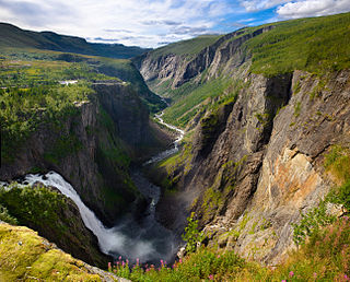
Vøring Falls on the Bjoreio River
Country Norway
Physical characteristics
Main source Tinnhølen, Eidfjord
1,213 m (3,980 ft)
River mouth Lake Eidfjord, Eidfjord
17.5 m (57 ft)
Length 72 km (45 mi)
Basin features
Basin size 627 km2 (242 sq mi)

The Bjoreio, also known as the Bjoreia, [1] is a river in the municipality of Eidfjord in Hordaland, Norway. [2] [3] [4] The river is 72 kilometers (45 mi) long, and it has a drainage basin of 627 square kilometers (242 sq mi). [2] Its natural average discharge is 25.2 cubic meters per second (890 cu ft/s), [5] but this is considerably less today because of hydroelectric infrastructure along the watercourse.

Eidfjord Municipality in Hordaland, Norway

Eidfjord is a municipality in Hordaland county, Norway. The municipality is located in the traditional district of Hardanger. The administrative centre of the municipality is the village of Eidfjord, where the majority of the municipal population lives. The other major population centre in the municipality is the village of Øvre Eidfjord.

Hordaland County (fylke) of Norway

Hordaland is a county in Norway, bordering Sogn og Fjordane, Buskerud, Telemark, and Rogaland counties. Hordaland is the third largest county after Akershus and Oslo by population. The county government is the Hordaland County Municipality which is located in Bergen. Before 1972, the city of Bergen was its own separate county apart from Hordaland.

Norway constitutional monarchy in Northern Europe

Norway, officially the Kingdom of Norway, is a Nordic country in Northwestern Europe whose territory comprises the western and northernmost portion of the Scandinavian Peninsula; the remote island of Jan Mayen and the archipelago of Svalbard are also part of the Kingdom of Norway. The Antarctic Peter I Island and the sub-Antarctic Bouvet Island are dependent territories and thus not considered part of the kingdom. Norway also lays claim to a section of Antarctica known as Queen Maud Land.

The Bjoreio has its origin on the northwest side of Sildabunutane, a 1,444-meter (4,738 ft) mountain in Hardangervidda National Park. The river, which is called the Eitro here, then runs southeast through Sildabudalen, a wide valley, and into Langavatnet, a lake at an elevation of 1,223 meters (4,012 ft). Under the name Snero the river continues the short distance to Tinnhølen, a lake at 1,213 meters (3,980 ft). When it flows out of Tinnhølen the river is now named Bjoreio, and it runs to the northwest out of the national park and down through the Bjorei Valley (Bjoreidalen). At the Nybu tourist lodge it is joined by the Svinto from the east. Here the river runs through the Bjorei Valley Nature Reserve (Bjoreidalen naturreservat). In the nature reserve there is a ban on walking outside specially marked trails from May 20 to July 20 to protect nesting birds. [6] Further downstream, at Storlia, is the 81-meter (266 ft) high Sysen Dam, a large stone embankment that creates Lake Sysen on the Leiro River just before it empties into the Bjoreio. The rivers continues westward through the Sysen Valley, where its tributaries include the Isdølo from the north and the Drolstølbekken from the south. At Fossli the river creates 182-meter (597 ft) high Vøring Falls, where it hurtles down into the narrow and deep Måbø Valley. The river empties into Lake Eidfjord in Øvre Eidfjord, only 500 meters (1,600 ft) from the nearby Veig River. At the opposite end of Lake Eidfjord, the short Eio River empties into the Hardanger Fjord. [7]

Hardangervidda National Park national park

Hardangervidda National Park, at 3,422 square kilometers, is Norway's largest national park. It spans from Numedal and Uvdal in the east and Røvelseggi and Ullensvang in the west across the Hardanger mountain plateau (Hardangervidda). Designated as a national park in 1981, today it serves as a popular tourist destination for activities such as hiking, climbing, fishing, and cross-country skiing. The Norwegian Mountain Touring Association (DNT) maintains a comprehensive network of huts and paths across Hardangervidda. The Bergen Line and the main Highway 7 cross the plateau.

Tinnhølen or Tinnhylen is a lake in Norway that lies in the municipality of Eidfjord in Hordaland county and a very small part crosses into the municipality of Nore og Uvdal in Buskerud county. The lake lies just inside Hardangervidda National Park on the vast Hardangervidda plateau. The northern part of the lake is accessible by road.

Sysen Dam stone embankment dam

The Sysen Dam is a rock-fill embankment dam in the municipality of Eidfjord in Hordaland, Norway. The dam is 1,157 meters (3,796 ft) long, 81 meters (266 ft) high, and 258 meters (846 ft) wide at its base. It is built of 3.6 million cubic meters of stone and moraine deposits.

Together with the nearby Sima River to the north, the Bjoreio River has been developed for power production at the Sima Hydroelectric Power Station. [8] Lake Sysen is used as the main reservoir. The river's flow has been diverted through a tunnel to the lake and, together with the upper course of the Isdølo, the water is then directed to the power station below Kjeåsen on the north side of the Simadal Fjord. The river bed below the Sysen Dam is dry for most of the year, but during the summer season it is required to release water so that the flow at Vøring Falls is at least 12 cubic meters per second (420 cu ft/s).

The Sima is a river in the municipality of Eidfjord in Hordaland, Norway. The river is 29.64 kilometers (18.42 mi) long, and it has a drainage basin of 125 square kilometers (48 sq mi) and an average discharge of 8.86 cubic meters per second (313 cu ft/s).

Sima Hydroelectric Power Station architectural structure

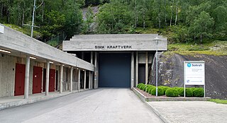
The Sima Power Station is a hydroelectric power station located in the municipality Eidfjord in Hordaland, Norway. It stands at the mouth of the Sima River. The facility Lang-Sima operates at an installed capacity of 500 MW, and has an average annual production of 1,212 GWh. The facility Sy-Sima has an installed capacity of 620 MW, and an average annual production of 1,640 GWh. Operator is Statkraft.

Kjeåsen Mountain farm in Western Norway, Norway

Kjeåsen is a mountain farm in the municipality of Eidfjord in Norway's Hardanger district, in Hordaland county. The farm lies at an elevation of 513 meters (1,683 ft) at the innermost point of the Simadal Fjord. The farm is no longer being worked, and one person lives there during the summer. The site is popular with tourists, especially Swedes. The farm has been referred to as "the world's most inaccessible farm."

At the lower end of Lake Måbø (Måbøvatnet), the old road through the valley crosses the river over the Måbø Bridge. [9]

Måbø Bridge

The Måbø Bridge is a stone arch bridge over the Bjoreio River in the Måbø Valley just below Lake Måbø (Måbøvatnet) in the municipality of Eidfjord in Hordaland, Norway.

Related Research Articles

Fjord A long, narrow inlet with steep sides or cliffs, created by glacial activity

Geologically, a fjord or fiord is a long, narrow inlet with steep sides or cliffs, created by a glacier. There are many fjords on the coasts of Alaska, Antarctica, British Columbia, Chile, Greenland, the Faroe Islands, Iceland, Kamchatka, the Kerguelen Islands, New Zealand, Norway, Novaya Zemlya, Labrador, Nunavut, Newfoundland, Quebec, Scotland, South Georgia Island, and Washington state. Norway's coastline is estimated at 29,000 kilometres (18,000 mi) with nearly 1,200 fjords, but only 2,500 kilometres (1,600 mi) when fjords are excluded.

Ulvik Municipality in Hordaland, Norway

Ulvik is a municipality in Hordaland county, Norway. The municipality stretches from the Hardangerfjord to the mountains that reach 1,800 metres (5,900 ft) above sea level. The administrative centre of the municipality is the village of Ulvik. The villages of Osa and Finse are also located in Ulvik municipality.

Hol Municipality in Buskerud, Norway

Hol is a municipality in Buskerud county, Norway.

Luster, Norway Municipality in Sogn og Fjordane, Norway

Luster is a municipality in Sogn og Fjordane county, Norway. It is located at the end of the Sognefjorden in the traditional district of Sogn. The administrative centre is the village of Gaupne. Other villages in Luster include Fortun, Hafslo, Indre Hafslo, Jostedal, Luster, Nes, Ornes, Skjolden, Solvorn, and Veitastrond.

Eidfjordvatnet is a moraine-dammed lake in the municipality of Eidfjord in Hordaland county, Norway. The 3.55-square-kilometre (1.37 sq mi) lake is located immediately southeast of the village of Eidfjord. The village of Øvre Eidfjord lies on the southern shore of the lake. Norwegian National Road 7 runs along the western shore of the lake. The water enters the lake through the Bjoreio and Veig rivers, and the water empties from the lake through the Eio River.

Sysenvatnet is a lake in the municipality of Eidfjord in Hordaland county, Norway. The 10.24-square-kilometre (3.95 sq mi) lake lies at the north end of the Sysendalen valley, about 8 kilometres (5.0 mi) east of the famous Vøringfossen waterfall. The lake is dammed on the south end by a large stone embankment, and the lake is used as the main reservoir for the Sima Hydroelectric Power Station. The Sysen Dam can easily be seen from Norwegian National Road 7, which runs near the southern shore of the lake.

Langavatnet is a lake in the municipality of Odda in Hordaland county, Norway. The 6.19-square-kilometre (2.39 sq mi) lake lies about 10 kilometres (6.2 mi) straight east of the town of Odda. The lake has a dam at the north end to regulate the water level for the purposes of hydroelectric power generation. The water of the lake previously flowed north to create the large Ringedalsfossen waterfall which now only flows when the lake gets too full. The water flows over the falls into the lake Ringedalsvatnet before flowing through the short river Tysso which empties into the Sørfjorden.

Simadal Fjord

The Simadal Fjord is a branch of the Eid Fjord in the municipality of Eidfjord in Hordaland, Norway. The Simadal Fjord is the innermost branch of the Hardanger Fjord. It is 5 kilometers (3.1 mi) long and extends east from its mouth between Blurnes and Eikenes to the head of the fjord at the Sima Valley.

Sima Valley

The Sima Valley is a river valley in the municipality of Eidfjord in Hordaland county, Norway. The 8-kilometre (5.0 mi) long valley begins below Lake Rembesdal, with an elevation of 905 meters (2,969 ft), which is one of the sources of the Sima River. The valley then runs west along the river to the Sima Hydroelectric Power Station at the head of the Simadal Fjord, where the river empties into the fjord. Norwegian County Road 103 runs through part of the valley and then continues along the south side of the fjord.

Måbø Tunnel

The Måbø Tunnel is a 1,893-meter (6,211 ft) tunnel along Norwegian National Road 7 in the municipality of Eidfjord in Hordaland, Norway.

The Kvernhushaug Tunnel is a 542-meter (1,778 ft) tunnel along Norwegian National Road 7 in the municipality of Eidfjord in Hordaland, Norway.

Eio (river) river in Norway

The Eio is a short but powerful river in the municipality of Eidfjord in Hordaland, Norway. It runs from Lake Eidfjord into Eid Fjord and is 2.1 kilometers (1.3 mi) long. The river is the lowermost part of the Eidfjord river system, which, in addition to the Eio, includes the Bjoreio and Veig rivers, which flow into Lake Eidfjord. The river system has a drainage basin of 1,174 square kilometers (453 sq mi) and a length of 78.5 kilometers (48.8 mi) reckoned from the furthest source of the Bjoreio on the Hardanger Plateau to the mouth of the Eio in the fjord.

Veig

The Veig is a river in the municipalities of Eidfjord and Ullensvang in Hordaland, Norway. The river is 44.6 kilometers (27.7 mi) long and has a drainage basin of 497.86 square kilometers (192.22 sq mi). Its average discharge is 23.22 cubic meters per second (820 cu ft/s).

Norwegian County Road 103

County Road 103 is a 9.2 kilometers (5.7 mi) long county road running east from Eidfjord, Norway.

Ringøy Village in Western Norway, Norway

Ringøy is a small village in the municipality of Eidfjord in Hordaland county, Norway.

References

  1. Rosvold, Knut A. "Sima kraftverk". Store norske leksikon. Retrieved April 28, 2018.
  2. 1 2 "Bjoreia". Store norske leksikon. Retrieved April 28, 2018.
  3. "Bjoreio, Eidfjord (Hordaland)". Yr. Norwegian Meteorological Institute and the Norwegian Broadcasting Corporation. Retrieved April 28, 2018.
  4. Bjoreio (PDF). Oslo: Miljøverndepartemetet. 1989. ISBN   82-7243-707-4 . Retrieved April 28, 2018.
  5. "Nedbørfelt (REGINE)" . Retrieved April 28, 2018.
  6. "Bjoreidalen". Miljødirektoratet. Retrieved April 29, 2018.
  7. "Bjoreio". Norgeskart. Retrieved April 29, 2018.
  8. Skoglund, Helge; Skår, Bjørnar; Gabrielsen, Sven-Erik; Barlaup, Bjørn T. (2013). Fiskebiologiske undersøkelser i Sima med vurdering av vintervannføring og stranding av gytegroper. 2011, 2012 og 2013 (PDF). Bergen: LFI Uni Miljø. Retrieved April 28, 2018.
  9. Nasjonal verneplan for veger, bruer og vegrelaterte kulturminner. Oslo: Vegdirektoratet. 2002. p. 170. Retrieved April 30, 2018.

Coordinates: 60°25′40″N7°07′20″E / 60.42778°N 7.12222°E / 60.42778; 7.12222

Geographic coordinate system Coordinate system

A geographic coordinate system is a coordinate system that enables every location on Earth to be specified by a set of numbers, letters or symbols. The coordinates are often chosen such that one of the numbers represents a vertical position and two or three of the numbers represent a horizontal position; alternatively, a geographic position may be expressed in a combined three-dimensional Cartesian vector. A common choice of coordinates is latitude, longitude and elevation. To specify a location on a plane requires a map projection.