
Lesjaskogsvatnet is a lake in Lesja Municipality in Innlandet county, Norway. The 4.3-square-kilometre (1.7 sq mi) lake lies in the upper Gudbrandsdalen valley, between the villages of Lesjaskog and Lesjaverk. The European route E136 highway and the Raumabanen railway line both run along the north side of the lake.

Altevatnet (Norwegian) or Álddesjávri (Northern Sami) is Norway’s 11th largest lake. The 79.71-square-kilometre (30.78 sq mi) lake lies in the Bardu Municipality in Troms og Finnmark county, Norway. The lake is the largest lake in the county. It is approximately 38 kilometres (24 mi) long and about 2.5 kilometres (1.6 mi) wide. The lake is regulated by a dam on the northwestern end of the lake. The surface lies 489 metres (1,604 ft) above sea level and reaches a maximum depth of 99 metres (325 ft) below the surface of the lake.

Møsvatn or Møsvann is a lake in Vinje Municipality in Vestfold og Telemark county, Norway. It is the tenth-largest lake in Norway with a surface area of 79.1 square kilometres (30.5 sq mi) and a volume of 1,573,523,000 cubic metres (1,275,676 acre⋅ft). The lake lies just east of the Hardangervidda National Park, in Skien watershed (Skiensvassdrag) catchment area. The lake discharges into the Måna river at a dam located on the Vinje-Tinn municipal border. The lake has an irregular shape with three arms. The longest length across the lake is about 40 kilometres (25 mi). Møsvatn is a shallow mountain lake by Norwegian standards, reaching a maximum depth of 68.5 metres (225 ft).
Arstaddalsdammen is a lake that lies in the municipality of Beiarn in Nordland county, Norway. It is located about 15 kilometres (9.3 mi) southwest of the village of Moldjord. The 2.54-square-kilometre (0.98 sq mi) lake lies in the southern end of the Arstaddal valley, and it has a dam on the northern end. The dam was built in the 1960s. The water from the lake is piped to the nearby lake Sokumvatnet in Gildeskål Municipality. The lake serves as a reservoir for the Sundsfjord Hydroelectric Power Station.
Inner-Sildvikvatnet (Norwegian) or Ruoidnajávri (Northern Sami) is a lake in Narvik Municipality in Nordland county, Norway. The 2.29-square-kilometre (0.88 sq mi) lake lies south of the Rombaken fjord. The lake has a dam on the northern end and the water is used for hydroelectric power production.

Storakersvatnet or Akersvatnet is a lake in the municipality of Rana in Nordland county, Norway. The lake lies about 15 kilometres (9.3 mi) south of the town of Mo i Rana and less than 900 metres (3,000 ft) from the border with Sweden. The original lake was only 15.9 square kilometres (6.1 sq mi), but a dam was built at the northern end so that it can serve as a reservoir for the Rana power station. This dam has caused the lake to enlarge to an area of 42.3 square kilometres (16.3 sq mi).

Aursjøen is a lake in Norway on the border between Lesja Municipality in Innlandet county and Molde Municipality in Møre og Romsdal county. The 36.38-square-kilometre (14.05 sq mi) lake sits at an elevation of 856 metres (2,808 ft) above sea level and is about 70.67 kilometres (43.91 mi) around.
Kilefjorden is a lake on in Agder county, Norway. The lake is located on the border of the municipalities of Evje og Hornnes, Iveland, and Vennesla. The lake is part of the river Otra. The lake is located about 6 kilometres (3.7 mi) west of the village of Birketveit in Iveland, about 2.5 kilometres (1.6 mi) north of the village of Hægeland in Vennesla, and about 15 kilometres (9.3 mi) south of the village of Hornnes in Evje og Hornnes.
Byglandsfjorden is a lake in Agder county, Norway. The 32.79-square-kilometre (12.66 sq mi) lake lies on the river Otra, primarily in the municipality of Bygland, but the far southern tip of the lake extends into the neighboring municipality of Evje og Hornnes. The river flows out of the lake Åraksfjorden to the north and into the Byglandsfjorden through a narrow channel, and the southern end of the Byglandsfjorden is marked by a dam along the river. The villages of Byglandsfjord, Grendi, Longerak, Lauvdal, and Bygland are all located on the eastern shore of the lake along the Norwegian National Road 9. The western shore of the lake is much more sparsely populated, with County Road 304 following that shoreline.
Fjergen is a lake in the municipality of Meråker in Trøndelag county, Norway. The 14.41-square-kilometre (5.56 sq mi) lake has a hydropower dam on the southern end which flows out into the Kåpperåa river which is part of the Stjørdalselva river system. There is about 204,000,000 cubic metres (7.2×10⁹ cu ft) of water stored in the lake.
Funnsjøen is a lake in the municipality of Meråker in Trøndelag county, Norway. The 8-square-kilometre (3.1 sq mi) lake flows into the Funna river, a part of the Stjørdalselva river system. The lake has a hydropower dam at the southern end of the lake. There is about 64,000,000 cubic metres (84,000,000 cu yd) of water stored behind the dame in the lake.
Valldalsvatnet is a lake in Ullensvang Municipality in Vestland county, Norway. The 6.78-square-kilometre (2.62 sq mi) lake lies about 6 kilometres (3.7 mi) northeast of the village of Røldal. The lake has a dam at the southern end, and it is used to regulate the water level for purposes of hydroelectric power generation. The lake was originally about 2.5 kilometres (1.6 mi) long and surrounded by many dairy farms. Since the 80-metre (260 ft) tall dam was built, the lake grew to about 10 kilometres (6.2 mi) long. This lake and the neighboring lakes of Votna and Røldalsvatnet are all regulated together as part of the Røldal-Suldal watershed which feeds a nearby hydroelectric power station.
Hoklingen is a lake in the municipality of Levanger in Trøndelag county, Norway. The 6.1-square-kilometre (2.4 sq mi) lake lies just to the east of the village of Åsen and about 6 kilometres (3.7 mi) south of the village of Skogn.

Viddalsdammen is a lake and a reservoir in Aurland Municipality in Vestland county, Norway. The reservoir has an area of 4.13-square-kilometre (1.59 sq mi) and the elevation varies between 930 metres (3,050 ft) and 868 m (2,848 ft) above sea level. Viddalsdammen is located at the end of the Låvisdalen valley, about 11 kilometres (6.8 mi) southeast of the village of Aurlandsvangen, about 7 kilometres (4.3 mi) southeast of the village of Flåm, and about 6 kilometres (3.7 mi) northeast of Myrdal Station.
Virdnejávri is a lake in the municipality of Kautokeino-Guovdageaidnu in Troms og Finnmark county, Norway. The 5.39-square-kilometre (2.08 sq mi) lake is a man-made lake located on the river Kautokeinoelva which flows over the Finnmarksvidda plateau. The dam at the northern end is part of the Alta Hydroelectric Power Station.
Bjørnstadvatnet is a lake in Hammerfest Municipality in Troms og Finnmark county, Norway. The 4.63-square-kilometre (1.79 sq mi) lake lies about 5 kilometres (3.1 mi) east of the village of Saraby. The lake has a dam on the northern end of the lake, and it is regulated for hydroelectric power.
Juovvajávri (Northern Sami) or Urvannet (Norwegian) is a lake in Alta Municipality in Troms og Finnmark county, Norway. The 2.24-square-kilometre (0.86 sq mi) lake lies on the Finnmarksvidda plateau about 7 kilometres (4.3 mi) northeast of the lake Stuorajávri and about 7 kilometres (4.3 mi) northwest of the large lake Iešjávri.
Kovvannet or Kovvatnet (Norwegian) or Buođgajávri (Northern Sami) is a lake in Alta Municipality in Troms og Finnmark county, Norway. It is located on the mainland, immediately north of the Langfjorden and about 6 kilometres (3.7 mi) straight east of the village of Øksfjordbotn. The lake has two small dams on the southeast end of the lake. The dams are part of a hydroelectric power plant, located just east of the lake.
Songavatnet is a lake in Vinje Municipality in Vestfold og Telemark county, Norway. It has a surface area of 29.86 square kilometres (11.53 sq mi) and lies at an elevation of 974 metres (3,196 ft). The lake lies just south of the border of Hardangervidda National Park and just southeast of the mountain Vassdalseggi. The villages of Haukeli and Edland are both located about 9 kilometres (5.6 mi) to the south of the lake and the village of Arabygdi lies about 10 kilometres (6.2 mi) to the southeast of the lake. The lake flows out into the river Songa which flows to the southeast into the nearby lake Totak.

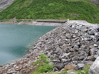
The Sysen Dam is a rock-fill embankment dam in the municipality of Eidfjord in Hordaland, Norway. The dam is 1,157 meters (3,796 ft) long, 81 meters (266 ft) high, and 258 meters (846 ft) wide at its base. It is built of 3.6 million cubic meters of stone and moraine deposits.


