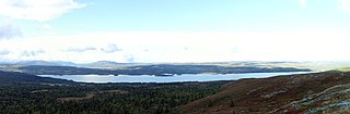
Tisleifjorden is a lake on the border of Innlandet and Buskerud counties in Norway. The lake lies in Nord-Aurdal municipality in Innlandet county, as well in Gol and Hemsedal municipalities in Buskerud county. Tisleifjorden is dammed for hydroelectric power. The height of the lake sits around 819 metres (2,687 ft) above sea level, but it can vary up to 11 metres (36 ft). The 13.54-square-kilometre (5.23 sq mi) lake has a circumference of about 32.5 kilometres (20.2 mi). It is located about 25 kilometres (16 mi) to the southwest of the town of Fagernes.
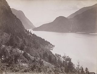
Bandak is a lake in the municipalities of Kviteseid and Tokke in Telemark county, Norway. The lake, which is part of the Telemark Canal route, belongs to the Skien watershed. The river Tokke flows into the lake, and the outlet is via the river Strauman, which flows to the lake Kviteseidvatn.
Blådalsvatnet is a glacial lake in the municipality of Kvinnherad in Vestland county, Norway. The 2.89-square-kilometre (1.12 sq mi) lake lies just outside the Folgefonna National Park, about 10 kilometres (6.2 mi) north of the village of Indre Matre. The lake is formed by the glacial runoff from the large Folgefonna glacier located just north of the lake. The lake is part of the water system used to power the Blåfalli kraftverk hydroelectric power station.
Juklavatnet is a lake on the border of the municipalities of Kvinnherad and Ullensvang in Vestland county, Norway. The 3.61-square-kilometre (1.39 sq mi) lake lies just outside Folgefonna National Park and immediately to the west of the Nordre Folgefonna glacier. The only road access comes from the small village of Nordrepollen in the Mauranger area of Kvinnherad municipality, about 10 kilometres (6.2 mi) south of the lake. There is a dam on the western end of the lake which regulates the depth of the water so that it can be used for hydroelectric power generation. The lake is the largest reservoir that feeds into the Mauranger power station.
Åmot is a village in Modum municipality in Buskerud, Norway. Located just south of Geithus, the two villages have grown closer to each other. They have a combined population of 5,694.
Stolsvatnet is a regulated lake in the municipalities of Ål and Hol in Buskerud, Norway. Stolsvatnet was formed in the late 1940s by the damming of the upper parts of three rivers, which created a continuous lake across the watersheds. The new lake covered a number of existing smaller lakes. It is a reservoir for Hol I kraftverk, a hydroelectric power plant located off FV 50 by Hovet in Hol. The power plant is owned and operated by E-Co Energi.
Nygardsvatnet is a lake in the municipality of Hol in Buskerud county, Norway. The lake is situated south of the Hallingskarvet mountain range. The lake serves as a reservoir for Usta kraftverk, a hydroelectric plant which was put into operation in 1965. The water level is controlled by a dam at the outlet and a tunnel down to lakes Sløddfjorden and Ustevatn. The Usta kraftverk power plant is owned and operated by E- CO Energi.
Øljusjøen is a lake in the municipalities of Hemsedal and Lærdal, Norway. The 8.45-square-kilometre (3.26 sq mi) lake is located at an elevation of 1,335 metres (4,380 ft) above sea level. It sits about 15 kilometres (9.3 mi) southeast of the village of Borgund and the European route E16 highway. The lake Eldrevatnet is 4 kilometres (2.5 mi) to the north. The lake Juklevatnet and the mountain Høgeloft are both about 12 kilometres (7.5 mi) to the northeast.
Ørteren is a lake in the municipality of Hol in Buskerud county, Norway.

Rødungen is a lake in Buskerud County, Norway. The lake is located on the border between the municipalities of Ål and Nore og Uvdal. Waterfall from the lake is a power source for Usta kraftverk, a hydro-electric plant. The power station exploits the fall of the Usta River from Rødungen as well as Ustevatn. The plant started production in 1965 and is owned and operated by E- CO Energi.
Samsjøen is a lake in Trøndelag county, Norway. The 10-square-kilometre (3.9 sq mi) lake sits on the border of the municipalities of Midtre Gauldal and Melhus. Most of the lake lies in Midtre Gauldal, about 12 kilometres (7.5 mi) north of the village of Singsås. The lake has a dam at the northwest end, which is used for hydroelectric power production. The water flows out of the lake and into the Lundesokna river which flows into the river Gaula.

Hen is a small village in the municipality of Ringerike in Buskerud, Norway.
Falningsjøen is a lake in Tynset Municipality in Innlandet county, Norway. The lake lies about 4.5 kilometres (2.8 mi) northeast of the village of Yset. The Ya River begins at this lake. The Forollhogna National Park boundary lies at the north end of the lake.

Ulla-Førre is a hydropower complex in Southern Norway. It is situated along the borders of the municipalities of Suldal and Hjelmeland and Bykle, Norway. It has an installed capacity of approximately 2,100 megawatts (2,800,000 hp), and the annual average production is 4.45 TWh (16.0 PJ) (1987–2006), while its reservoir capacity is about 7.8 TWh (28 PJ); at full production, it can last seven to eight months. The complex includes the artificial lake Blåsjø, which is made by dams around 1,000 metres (3,300 ft) above the sea level. The hydroelectric power stations in the complex are Saurdal, Kvilldal, Hylen and Stølsdal, operated by Statkraft.

The Aurland Power Station is a hydroelectric power station located in the municipality Aurland in Vestland, Norway, owned by E-CO Energi. It consists of five facilities, Aurland I, Aurland II, Aurland III, Reppa and Vangen, and operates at a combined installed capacity of 1,128 MW, with an average annual production of 2,869 GWh. The construction works were initiated in 1969, and the first production from Aurland I started in 1973.

Vamma Power Station is a hydroelectric power station located on the river Glomma approximately 4.5 km south of Askim, Østfold, Norway.
Sam Eyde formed Vamma Fossekompagnie in 1902 to build a power plant for a fertilizer factory. The factory plans were canceled in 1912 and Vamma Fossekompagnie was sold to Hafslund (company).
Construction of the power station started in 1907 and in 1915 the first two turbines were completed. Another six turbines were built between 1915 and 1927. In 1944 the final two were complete. The installed capacity at that point was 113 MW from ten horizontal Francis turbines with dual runners.

Evanger is a village in the municipality of Voss in Vestland county, Norway. The village lies in western Voss at the eastern end of the lake Evangervatnet where the river Vosso empties into the lake. Evanger sits about 20 kilometres (12 mi) west of the municipal centre of Vossevangen.

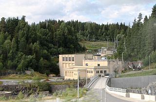
The Svorka Hydroelectric Power Station is a hydroelectric power station in the municipality of Surnadal in Møre og Romsdal county, Norway. It is located about 4 kilometers (2.5 mi) northeast of the village of Bøverfjorden. It utilizes a drop of 260 meters (850 ft) from the lake Langvatnet, which is regulated between 274 meters (899 ft) and 276 meters (906 ft), to the Bøvra River. The Svorka River is also regulated for the plant. Its catchment area is 104.5 square kilometers (40.3 sq mi). Water is also transferred from several lakes: Litlbøvervatnet is regulated between 343 meters (1,125 ft) and 333 meters (1,093 ft), Solåsvatnet and Geitøyvatnet are regulated between 336 meters (1,102 ft) and 331 meters (1,086 ft), and Andersvatnet is regulated between 294 meters (965 ft) and 305 meters (1,001 ft). The plant has a Francis turbine and operates at an installed capacity of 25 MW, and has an average annual production of about 111 GWh. The plant came into operation in 1963 and is owned 50% each by Svorka Energi and Statkraft.

The Ulset Hydroelectric Power Station is a hydroelectric power station in the municipality of Tynset in Hedmark county, Norway.


