Mørsvikvatnet (Norwegian) or Murgosjávrre (Lule Sami) is a lake located in Sørfold Municipality in Nordland county, Norway. The 1.1-square-kilometre (0.42 sq mi) lake lies on the northeastern side of the village of Mørsvikbotn. The European route E6 highway runs along the western edge of the lake.

Altevatnet (Norwegian) or Álddesjávri (Northern Sami) is Norway’s 11th largest lake. The 79.65-square-kilometre (30.75 sq mi) lake lies in Bardu Municipality in Troms county, Norway.
Blåmannsisvatnet (Norwegian) or Ålmåjalosjiegŋajávrre (Lule Sami) is a lake in Fauske Municipality in Nordland county, Norway. The 3.76-square-kilometre (1.45 sq mi) lake lies on the southeast edge of the large Blåmannsisen glacier, about 35 kilometres (22 mi) east of the town of Fauske. The border with Sweden is located about 6 kilometres (3.7 mi) east of the lake.

Faulvatnet (Norwegian) or Låddejávrre (Lule Sami) is a lake that lies in Sørfold Municipality in Nordland county, Norway. The 7.24-square-kilometre (2.80 sq mi) lake is located about 15 kilometres (9.3 mi) north of the village of Straumen, just west of Rago National Park. The water flows out into the Sleipdalselva river and the water is used for power generation at the Lakshola hydroelectric power station.
Grovatnet is a lake that lies in Sørfold Municipality in Nordland county, Norway. The 2.64-square-kilometre (1.02 sq mi) lake is located northeast of the Sagfjorden, about 15 kilometres (9.3 mi) southwest of the village of Mørsvikbotn.

Horndalsvatnet (Norwegian) or Tjoarvekjávrre (Lule Sami) is a lake located in Sørfold Municipality in Nordland county, Norway. The 3.5-square-kilometre (1.4 sq mi) lake lies about 7 kilometres (4.3 mi) southwest of the village of Mørsvikbotn.
Kjelvatnet (Norwegian) or Giebbnejávrre (Lule Sami) is a lake in Fauske Municipality in Nordland county, Norway. The 3.85-square-kilometre (1.49 sq mi) lake lies about 7 kilometres (4.3 mi) south of the village of Sulitjelma near the border with Junkerdal National Park. Water flows into the lake from the large lake Balvatnet and it flows out of the lake to the north along the Balmi River to the lake Langvatnet.
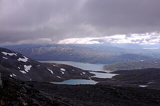
Kvitvatnet is a lake that lies in Sørfold Municipality in Nordland county, Norway. It is located in the southeastern part of the municipality, about 21 kilometres (13 mi) east of the village of Straumen. The lake lies on the north side of the Blåmannsisen glacier, just south of the Rago National Park, and just west of the border with Sweden.
Langvatnet is a lake that lies in Fauske Municipality in Nordland county, Norway. The 5.46-square-kilometre (2.11 sq mi) lake lies about 25 kilometres (16 mi) east of the town of Fauske. The village of Sulitjelma lies on the northeastern edge of the lake. Water from the lakes Kjelvatnet and Låmivatnet flow into the lake from the south and east. The water from Langvatnet flows out through the Sjønstå River to the west towards the lake Øvrevatnet.
Langvatnet (Norwegian) or Guhkesjávrre (Lule Sami) is a lake that lies in Sørfold Municipality in Nordland county, Norway. The 13.97-square-kilometre (5.39 sq mi) lake is located about 30 kilometres (19 mi) northeast of the village of Straumen, just north of Rago National Park and the border with Sweden.

Leirvatnet is a lake located on the border between Norway and Sweden. The majority of the 2.57-square-kilometre (0.99 sq mi) lake lies in Sørfold Municipality in Nordland county, Norway, and the remaining 0.06 square kilometres of the lake are located in Jokkmokk Municipality in Norrbotten County, Sweden. The lake lies at one end of the large Blåmannsisen glacier.

Litlverivatnet (Norwegian) or Bassejávrre (Lule Sami) is a lake that lies in Sørfold Municipality in Nordland county, Norway. The 3.98-square-kilometre (1.54 sq mi) lake is located about 15 kilometres (9.3 mi) northeast of the village of Straumen, inside of Rago National Park.
Lomivatnet (Norwegian) or Loamejávrre (Lule Sami) is a lake in Fauske Municipality in Nordland county, Norway. The 11.43-square-kilometre (4.41 sq mi) lake lies about 5 kilometres (3.1 mi) east of the village of Sulitjelma, just south of the Sulitjelma Glacier and north of Junkerdal National Park. The border with Sweden is 3 kilometres (1.9 mi) east of the lake. The Lomi Hydroelectric Power Station uses the lake as a reservoir.
Muorkkejávrre (Lule Sami) or Eidevatnet (Norwegian) is a lake that lies in Fauske Municipality in Nordland county, Norway. The 5.94-square-kilometre (2.29 sq mi) lake lies about 75 metres (246 ft) west of the border with Sweden and about 10 kilometres (6.2 mi) east of the village of Sulitjelma. The water from the lake flows west into the neighboring lake Låmivatnet. The ending -jávrre is the Lule Sami word for "lake".

Nedre Veikvatnet (Norwegian) or Vuolep Viejekjávrre (Lule Sami) is a lake that lies in Sørfold Municipality in Nordland county, Norway. The 2.27-square-kilometre (0.88 sq mi) lake lies about 15 kilometres (9.3 mi) southeast of the village of Mørsvikbotn. Nedre Veikvatnet has an inlet from the nearby lake Øvre Veikvatnet, and an outlet that connects to another nearby lake Kobbvatnet.
Rundvatnet is a lake that lies in Sørfold Municipality in Nordland county, Norway. It is located in the southeastern part of the municipality of Sørfold, about 15 kilometres (9.3 mi) east of the village of Straumen. The lake Sisovatnet lies immediately west of Rundvatnet; they are connected by the narrow Rundvasstraumen strait.
Sisovatnet (Norwegian) or Sijdasjávrre (Lule Sami) is a lake that lies in Sørfold Municipality in Nordland county, Norway. It is located in the southeastern part of the municipality of Sørfold, about 10 kilometres (6.2 mi) east of the village of Straumen. The lake Rundvatnet lies immediately east of Sisovatnet.

Storskogvatnet is a lake that lies in Sørfold Municipality in Nordland county, Norway. The 2.39-square-kilometre (0.92 sq mi) lake is located about 20 kilometres (12 mi) northeast of the village of Straumen, inside of Rago National Park.
Trollvatnet is a lake that lies in Sørfold Municipality in Nordland county, Norway. The 3.88-square-kilometre (1.50 sq mi) lake is located northeast of the Sagfjorden, about 20 kilometres (12 mi) west of the village of Mørsvikbotn.
Vuolep Sårjåsjávrre is a lake which lies on the border between Norway and Sweden. The western part lies in Fauske Municipality in Nordland county, Norway, and the eastern part lies in Jokkmokk Municipality in Norrbotten County, Sweden. The 7.17-square-kilometre (2.77 sq mi) lake lies just to the east of the large Blåmannsisen glacier and smaller neighboring lake Bajep Sårjåsjávrre.

