Vest-Agder was one of 18 counties (fylker) in Norway up until 1 January 2020, when it was merged with Aust-Agder to form Agder county. In 2016, there were 182,701 inhabitants, around 3.5% of the total population of Norway. Its area was about 7,277 square kilometres (2,810 sq mi). The county administration was located in its largest city, Kristiansand.

Sirdal is a municipality in Agder county, Norway. It is located in the northwestern part of the traditional district of Lister. The administrative centre of the municipality is the village of Tonstad. Other villages in Sirdal include Bjørnestad, Haughom, Kvæven, Lunde, and Tjørhom.

Flekkefjord is a municipality in Agder county, Norway. It is located in the traditional district of Lister. The administrative centre of the municipality is the town of Flekkefjord. The villages of Sira, Gyland, Rasvåg, Kirkehavn, and Åna-Sira are located in Flekkefjord.
Sira is a village in Flekkefjord municipality in Agder county, Norway. The village is located immediately east of the county border of Agder and Rogaland. The European route E39 highway passes by the village and the Sørlandet Line runs right through the village, stopping at Sira Station. The 0.66-square-kilometre (160-acre) village has a population (2015) of 630, giving the village a population density of 955 inhabitants per square kilometre (2,470/sq mi).
Lundevatn, or Lundevatnet, is a lake on the borders between the municipalities of Lund and Flekkefjord in Norway. The village of Moi lies at the northern end of the lake and the smaller village of Åna-Sira lies just south of the southern end of the lake. The lake has a small dam at the southern end and it is used for the nearby Åna-Sira Power Station.
Øyarvatnet or Øyarvatn is a lake in Agder county, Norway. It sits on the border between the municipalities of Valle and Sirdal, about 30 kilometres (19 mi) northeast of the village of Lunde in Sirdal and about 32 kilometres (20 mi) west of Austad in Bygland. The lake is part of the Kvina river system. It is located just to the south of the lake Rosskreppfjorden, which flows into it. The dam at the south end of the 8.05-square-kilometre (3.11 sq mi) lake keeps it at an elevation of 837 metres (2,746 ft).
Kolsvatnet is a lake in the municipality of Valle in Agder county, Norway. It is located about 14 kilometres (8.7 mi) southwest of the village of Valle and about 15 kilometres (9.3 mi) northwest of the village of Rysstad. The lake is located south of the lake Botnsvatnet, east of the mountain Urddalsknuten, and northeast of the lake Rosskreppfjorden. The lake has an area of 2.72 square kilometres (1.05 sq mi) and sits at an elevation of 1,034 metres (3,392 ft) above sea level.
Høvringsvatnet or Høvringsvatn is a lake in the municipality of Evje og Hornnes in Agder county, Norway. It's located about 10 kilometres (6.2 mi) northeast of the village area of Evje and about 6 kilometres (3.7 mi) southeast of the village area of Byglandsfjord. The lake Homstølvatnet in Froland municipality is located about 5 kilometres (3.1 mi) to the northeast.
Botnsvatnet or Botsvatnet is a lake in the municipality of Valle in Agder county, Norway. The 5.61-square-kilometre (2.17 sq mi) lake is located just north of the lakes Rosskreppfjorden and Kolsvatnet and the mountain Urddalsknuten, and it lies to the southeast of the mountain Bergeheii. The village of Valle is located about 14 kilometres (8.7 mi) to the east of the lake. The lake sits at an elevation of 1,020 metres (3,350 ft) above sea level.
Kumlevollvatnet or Kongevollvatnet is a lake in the municipality of Flekkefjord in Agder county, Norway. The 3.12-square-kilometre (1.20 sq mi) lake lies along the river Fedaelva, just south of Gyland and about 12 kilometres (7.5 mi) northeast of the town of Flekkefjord.
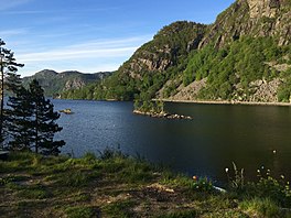
Sirdalsvatnet is a lake in the municipalities of Sirdal and Flekkefjord in Agder county, Norway. The 18.8-square-kilometre (7.3 sq mi) lake is about 27 kilometres (17 mi) long running from the village of Tonstad in the north to the village of Sira in the south. The lake is about 1 kilometre (0.62 mi) wide at its widest point.
Ytre Øydnavatnet is a lake in the municipality of Lyngdal in Agder county, Norway. The 3.22-square-kilometre (1.24 sq mi) lake is located along the river Audna, just south of the lake Øvre Øydnavatnet. The lake sits at an elevation of 96 metres (315 ft) above sea level. The 17.5-kilometre (10.9 mi) long lake lies about 5.5 kilometres (3.4 mi) south of the village of Byremo and about 3.6 kilometres (2.2 mi) north of the village of Konsmo.

Nes og Hitterø or Hitterø og Nes is a former municipality that was located in the old Vest-Agder county in Norway. It was located in the southwestern part of the present-day municipality of Flekkefjord in Agder county. It encompassed the Nes peninsula and the island of Hidra. The 240-square-kilometre (93 sq mi) municipality existed from 1838 until its dissolution in 1893. The administrative centre of the municipality was the small village of Sunde in Nes parish, located just outside the town of Flekkefjord.

Agder Flekkefjords Tidende is the local newspaper for the southern Norwegian town of Flekkefjord, and the surrounding region of western Vest Agder and eastern Rogaland.

The Flekkefjord Line is a 17.1-kilometre (10.6 mi) abandoned branch line to the Sørland Line. It ran between Sira and Flekkefjord in Agder, Norway. The only current activity on the line is tourist draisines. The station buildings along the line were designed by the architect Paul Armin Due—these have all been demolished.
Flekkefjord Station is a former railway station located in the town of Flekkefjord in the municipality of Flekkefjord in Vest-Agder county, Norway. It served as the terminus of the 1,067 mm gauge Flekkefjord Line from 1904 to 1990. The station building was designed by Paul Armin Due and was built in brick Art Nouveau.
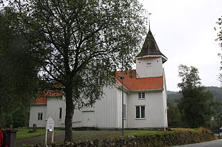
Flekkefjord Church is a parish church of the Church of Norway in the large Flekkefjord Municipality in Agder county, Norway. It is located in the town of Flekkefjord. It is the church for the Flekkefjord parish which is part of the Lister og Mandal prosti (deanery) in the Diocese of Agder og Telemark. The white, wooden church was built in the Empire style and in an octagonal design in 1833 using plans drawn up by the architect Hans Linstow. The church seats about 650 people.

Gillsvannet or Gjelsvannet is a freshwater lake in the municipality of Kristiansand in Agder county, Norway. The 1.05-square-kilometre (260-acre) lake is located about 5 kilometres (3.1 mi) northeast of downtown Kristiansand, along to County Road 452. The lake lies about 300 metres (980 ft) west of the Topdalsfjorden, at an elevation of about 1 metre above sea level. There is a practice range for kayaking on the lake as well as many areas used for swimming during the summer season. The Gimlekollen district lies on the southern shore of the lake and the village of Justvik lies just north of the lake.

Hidra is the largest island in Agder county, Norway. The 20.8-square-kilometre (8.0 sq mi) island lies in Flekkefjord municipality, south of the mainland coast, separated by the 350-metre (1,150 ft) wide Hidrasund strait and the Listafjorden. The island has about 500 residents, mostly living on the west side in Kirkehavn, where Hidra Church is located. The village of Rasvåg is another main village on the south side of the island. In 2007, the government of Norway studied the possibility of building an undersea tunnel to connect the island to the mainland without a ferry, but it was deemed to be too costly for the small benefit.

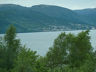
Flekkefjord is a town in Flekkefjord municipality in Agder county, Norway. The town is located at the end of the Flekkefjorden, a branch off the main Listafjorden. The town is the administrative centre of Flekkefjord municipality, the southwestern-most municipality in the county. Flekkefjord Church and Sørlandet Hospital Flekkefjord are both located in the town. In Norway, Flekkefjord is considered a by which can be translated as either a "town" or "city" in English.