Aust-Agder was one 18 counties (fylker) in Norway up to 1 January 2020, when it was merged with Vest-Agder to form Agder county. In 2002, there were 102,945 inhabitants, which was 2.2% of Norway's population. Its area was 9,212 square kilometres (3,557 sq mi). The county's administrative center was the town of Arendal.

Froland is a municipality in Agder county, Norway. It is part of the traditional region of Sørlandet. The administrative center is the village of Blakstad, which along with Osedalen form the main population center of the municipality. Other villages in Froland include Bøylefoss, Bøylestad, Froland, Frolands verk, Heldalsmo, Hinnebu, Hynnekleiv, Jomås, Lauvrak, Libru, Løvjomås, Mjåvatn, Mjølhus, Mykland, and Risdal.

Åmli is a municipality in Agder county, Norway. It is located in the traditional region of Sørlandet. The main population centre and administrative center is the village of Åmli which lies along the river Nidelva. Other villages in Åmli include Askland, Dølemo, Eppeland, Flaten, Hillestad, Homdrom, Lauveik, Nelaug, Øvre Ramse, Skjeggedal, Tveit, Vehus, and Ytre Ramse.

Bygland is a municipality in Agder county, Norway. It is located in the traditional district of Setesdal. The administrative centre of the municipality is the village of Bygland. Other villages in the municipality include Åraksbø, Austad, Byglandsfjord, Grendi, Langeid, Lauvdal, Litveit, Longerak, Moi, Ose, Sandnes, Skåmedal, and Tveit. The Norwegian National Road 9 runs through the municipality, following the river Otra where most of the population of Bygland lives.

Nelaug is a village in the southern part of the municipality of Åmli in Agder county, Norway. The population (2001) was 161. The village lies at east of the Nelaug lake, which is regulated by a hydroelectric power plant. The most notable feature in the village is the train station, Nelaug Station, which is the junction between the main Sørland Line and the branch Arendal Line. Nelaug school is a 1st through 6th grade elementary school. It is one of the three schools in Åmli municipality. Nelaug sits at the end of Norwegian County Road 412 which connects Nelaug to the Norwegian County Road 415 and the rest of Norway.

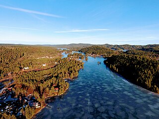
Nidelva is the main river in the Arendal drainage basin in Agder county, Norway. The 221.7-kilometre (137.8 mi) long river begins at the confluence of two rivers: Nisserelva and Fyreselv. The confluence is located by the village of Haugsjåsund in Nissedal municipality in southern Vestfold og Telemark county. The river flows south into the Skagerrak at the city of Arendal. The watershed covers 4,011 square kilometres (1,549 sq mi) and has an average waterflow of 114.4 cubic metres per second (4,040 cu ft/s) at Rykene near the mouth. The highest waterflow ever recorded on the river was 1,200 cubic metres per second (42,000 cu ft/s) in the autumn of 1987.

Rykene or Rygene is a village located along the river Nidelva in Agder county, Norway. The village is primarily located in Arendal municipality, but a small portion of the village lies across the river in the neighboring municipality of Grimstad. Rykene is located about 10 kilometres (6.2 mi) north of the town of Grimstad and about the same distance south of the city of Arendal. Historically, the village grew up due to its close proximity to forests as the timber was floated down river to the sawmills in Rykene. The village of Lindtveit lies about 2 kilometres (1.2 mi) to the northwest, the village of Løddesøl lies about 4 kilometres (2.5 mi) to the north, the village of Gjennestad lies about 3 kilometres (1.9 mi) to the northeast. The village sits at the junction of Norwegian County Road 407 and Norwegian County Road 408.

Blakstad or Blakstad-Osedalen is a village which is also the administrative centre of the municipality of Froland in Agder county, Norway. It is located along the river Nidelva, about 10 kilometres (6.2 mi) northwest of the town of Arendal. The small village of Froland lies about 3 kilometres (1.9 mi) to the north, on the west side of the river, and that is where Froland Church is located.
Vegår is a lake in the municipality of Vegårshei in Agder county, Norway. The 17.7-square-kilometre (6.8 sq mi) lake is located about 3 kilometres (1.9 mi) north of the municipal center of Myra and about 12 kilometres (7.5 mi) east of the village of Åmli in the neighboring municipality of Åmli.

Homstølvatnet or Eptevatn is a lake in the far western part of the municipality of Froland in Agder county, Norway. It is located about 12 kilometres (7.5 mi) east of the village of Byglandsfjord (in Bygland municipality) and about 16 kilometres (9.9 mi) northwest of the village of Mykland in Froland. The lake was expanded in 1973 when a dam was built at the south end of the lake Eptevatn for the purposes of hydroelectric power generation. The dam made the lake larger so that it now includes the formerly separate lake Homstølvatnet as one large lake. The lake is now 3.92-square-kilometre (1.51 sq mi) large and it holds about 44 cubic megametres (3.6×10¹⁶ acre⋅ft) as a reservoir for the power station.

Mykland is a rural village in northwestern Froland municipality in Agder county, Norway. It is located along the Norwegian County Road 42 about 28 kilometres (17 mi) northwest of the village of Blakstad and about 30 kilometres (19 mi) southwest of the village of Åmli. The village is located in a hilly, forested area that is the site of many small rivers and lakes. The village of Mykland was the administrative centre of the old municipality of Mykland which existed from 1876 until 1967 when the municipality was merged into Froland. The village has a school, store, gas station, and Mykland Church.

Herefoss is a village in Birkenes municipality in Agder county, Norway. The village is located on the northeastern end of the Herefossfjorden which is a large lake on the river Tovdalselva. The Norwegian National Road 41 runs through the village connecting it to Søre Herefoss, about 8 kilometres (5.0 mi) to the south, and to Hynnekleiv in Froland, about 10 kilometres (6.2 mi) to the north. The lake Uldalsåna lies about 2 kilometres (1.2 mi) to the northwest.
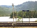
Froland Station is a railway station in the village of Froland which lies along the river Nidelva in Froland municipality in Agder county, Norway. Located along the Arendalsbanen railway line, it is served by Go-Ahead Norge. The station was opened in 1908 as part of Arendal–Åmli Line.

Bøylestad is a village in Froland municipality in Agder county, Norway. The village is located along the river Nidelva about 10 kilometres (6.2 mi) northeast of the village of Blakstad–Osedalen and about 2.5 kilometres (1.6 mi) south of the village of Bøylefoss. The population of Bøylestad (2001) was 214.

Bøylefoss is a village in Froland municipality in Agder county, Norway. The village is located along the river Nidelva at the location of the Bøylefoss waterfall. The river is dammed so the waterfall is no longer visible. The water is piped downhill to the Bøylefoss power plant on the shore of the river. There is a very small village near the power plant also called Bøylefoss. The nearby village of Bøylestad lies about 2.5 kilometres (1.6 mi) south of Bøylefoss.

Frolands verk is a small village area in Froland municipality in Agder county, Norway. The village is located along the Norwegian County Road 42, almost 5 kilometres (3.1 mi) west of the municipal centre of Blakstad/Osedalen and about 7 kilometres (4.3 mi) southeast of the village of Mjåvatn. The lake Trevann lies just south of the village.

Norwegian National Road 41 is a Norwegian national road that runs through Vestfold og Telemark and Agder counties in Norway. The road runs between the village of Brunkeberg in Kviteseid municipality in Vestfold og Telemark county in the north and Timenes in Hånes in the city of Kristiansand in Agder county in the south. The 172.9-kilometre (107.4 mi) long road connects to the European route E134 highway in the north and to the European route E18 highway in the south. The road runs for 101.5 kilometres (63.1 mi) in Agder county and 71.4 kilometres (44.4 mi) in Vestfold og Telemark county. The southern half of the road runs along the river Tovdalselva and the lake Herefossfjorden, and it is located in a fault zone called the Kristiansand-Porsgrunn grabenen.

Åmli is the administrative centre of Åmli municipality in Agder county, Norway. The village is located along the Norwegian National Road 41 and the river Nidelva, about 30 kilometres (19 mi) northwest of the town of Tvedestrand via the Norwegian County Road 415. The village of Nelaug lies about 15 kilometres (9.3 mi) to the southeast and the village of Dølemo lies about 10 kilometres (6.2 mi) to the southwest. The 0.81-square-kilometre (200-acre) village has a population (2019) of 697 which gives the village a population density of 855 inhabitants per square kilometre (2,210/sq mi).

Mykland is a former municipality in the old Aust-Agder county in Norway. The 306-square-kilometre (118 sq mi) municipality existed from 1876 until 1967 when it was merged into the neighboring municipality of Froland in what is now Agder county. Mykland included the inland areas between the rivers Tovdalsåna and the Rettåna. The administrative centre was the village of Mykland where the Mykland Church is located.
Froland is a small village in Froland municipality in Agder county, Norway. The village is located on the western shore of the river Nidelva, just about 3 kilometres (1.9 mi) north of the municipal centre of Blakstad. The village is the site of Froland Church, the main church for the municipality. The Arendalsbanen railway line runs through the village, stopping at Froland Station.