
Orkdal is a former municipality in Trøndelag county, Norway. The municipality existed from 1838 until its dissolution in 2020 when it joined Orkland Municipality. It was part of the Orkdalen region. The administrative centre of the municipality was the city of Orkanger. Some of the notable villages in the municipality included Kjøra, Geitastrand, Gjølme, Thamshavn, Fannrem, Vormstad, Svorkmo, and Hoston.

Svorkmo is a village in the municipality of Orkland in Trøndelag county, Norway. It is situated in the Orkdalen valley along the river Orkla about 60 kilometres (37 mi) west-southwest of the city of Trondheim. Svorkmo is located about 3.5 kilometres (2.2 mi) south of the village of Vormstad and about 11 kilometres (6.8 mi) south of the urban area of Orkanger-Fannrem-Råbygda. The lake Svorksjøen lies about 7 kilometres (4.3 mi) to the east of the village.
Rien is a lake in the municipality of Røros in Trøndelag county, Norway. The 14.87-square-kilometre (5.74 sq mi) lake is located near the headwaters of the river Glomma, only about 10 kilometres (6.2 mi) west of the border with Sweden. The water flows out through the river Glomma and heads a short distance south, into the large lake Aursunden. The village of Brekken lies about 6 kilometres (3.7 mi) south of the lake and the town of Røros lies about 40 kilometres (25 mi) to the southwest.
Øyangsvatnet is a lake in the municipality of Orkland in Trøndelag county, Norway. The lake lies in the west central part of Agdenes, just east of the border with Snillfjord municipality. The lake is about 6.5 kilometres (4.0 mi) west of the villages of Lensvik and Selbekken and about 9 kilometres (5.6 mi) west of the village of Ingdalen.

Svorksjøen is a lake in Trøndelag county, Norway. The 3.55-square-kilometre (1.37 sq mi) lake lies on the border of the municipalities of Melhus and Orkland. The lake lies about 6 kilometres (3.7 mi) east of the village of Svorkmo and about 10 kilometres (6.2 mi) southwest of the village of Korsvegen.
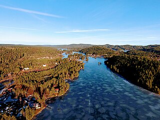
Våvatnet is a lake in Orkland Municipality in Trøndelag county, Norway. The lake was dammed in 1910 and is used as the main reservoir for the municipality of Orkdal. The water flows into the lake Songsjøen and then into the lake Gagnåsvatnet.
Hostovatnet is a lake in Trøndelag county, Norway. The 3.14-square-kilometre (1.21 sq mi) lake lies in Orkland Municipality. The village of Hoston is located on the northeastern shore of the lake.
Vegår is a lake in the municipality of Vegårshei in Agder county, Norway. The 17.7-square-kilometre (6.8 sq mi) lake is located about 3 kilometres (1.9 mi) north of the municipal center of Myra and about 12 kilometres (7.5 mi) east of the village of Åmli in the neighboring municipality of Åmli.
Longerakvatnet or Longeraksvatnet is a lake in the municipality of Bygland in Agder county, Norway. It has a small dam on the southwest side to regulate the water level for hydro-electric power generation at a plant located down the hill. The lake discharges into the Longeraksåni river which flows into the Byglandsfjorden near the village of Longerak. The 3.4-square-kilometre (1.3 sq mi) lake is located about 6 kilometres (3.7 mi) southeast of the village of Lauvdal and about 10 kilometres (6.2 mi) northeast of the village of Byglandsfjord.
Fjergen is a lake in the municipality of Meråker in Trøndelag county, Norway. The 14.41-square-kilometre (5.56 sq mi) lake has a hydropower dam on the southern end which flows out into the Kåpperåa river which is part of the Stjørdalselva river system. There is about 204,000,000 cubic metres (7.2×10⁹ cu ft) of water stored in the lake.
Holden is a lake in the municipality of Steinkjer in Trøndelag county, Norway. It is located about 8 kilometres (5.0 mi) west of the village of Malm and about 10 kilometres (6.2 mi) north of the village of Follafoss. The 13.31-square-kilometre (5.14 sq mi) lake has a dam on the southern end to control the water for hydroelectric power. The lake flows out into the Follaelva river which flows into the Trondheimsfjord at the village of Follafoss.

Skogseidvatnet is a lake in Bjørnafjorden Municipality in Vestland county, Norway. The 5.3-square-kilometre (2.0 sq mi) lake lies in the Hålandsdal valley, about 7 kilometres (4.3 mi) east of the village of Eikelandsosen. Water from the river Orraelva and the lake Gjønavatnet flow into the lake, and then it flows out into the lake Henangervatnet before flowing out into the fjord.
Gravatnet is a lake in the municipality of Sirdal in Agder county, Norway. The 5.33-square-kilometre (2.06 sq mi) lake is located about 9 kilometres (5.6 mi) north of the small village of Lunde. The lake lies immediately south of the lake Valevatn, which flows out into Gravatnet. The water in Gravatnet is stopped by a dam on the south side. The water is regulated at an elevation of 660 metres (2,170 ft) and it flows out through the small river Gravassåni which is a tributary of the big river Sira.
Hoklingen is a lake in the municipality of Levanger in Trøndelag county, Norway. The 6.1-square-kilometre (2.4 sq mi) lake lies just to the east of the village of Åsen and about 6 kilometres (3.7 mi) south of the village of Skogn.
Samsjøen is a lake in Trøndelag county, Norway. The 10-square-kilometre (3.9 sq mi) lake sits on the border of the municipalities of Midtre Gauldal and Melhus. Most of the lake lies in Midtre Gauldal, about 12 kilometres (7.5 mi) north of the village of Singsås. The lake has a dam at the northwest end, which is used for hydroelectric power production. The water flows out of the lake and into the Lundesokna river which flows into the river Gaula.

Holsavatnet is a lake which lies in the municipality of Sunnfjord in Vestland county, Norway. The lake is located about 12 kilometres (7.5 mi) east of the town of Førde and about 9.5 kilometres (5.9 mi) east of the village of Bruland. The village of Holsen lies at the eastern end of the lake. The European route E39 highway passes 3 kilometres (1.9 mi) west of the lake. The water from the lake eventually flows into the river Jølstra.
Galtsjøen is a lake on the border of the municipalities of Rendalen and Engerdal in Innlandet county, Norway. The 3.5-square-kilometre (1.4 sq mi) lake is considered the headwaters of the river Femundselva which flows south into Sweden. The lake inlet is through the Galtstrømmen which comes from the small lake Galthåen which in turn has an inlet from the lake Isteren and Femund. The lake Sølensjøen lies about 2.5 kilometres (1.6 mi) to the west of Galtsjøen.

Ångardsvatnet is a lake in the municipality of Oppdal in Trøndelag county, Norway. The 3.24-square-kilometre (1.25 sq mi) lake lies in the Storlidalen valley, about 13 kilometres (8.1 mi) northwest of the village of Lønset and about 35 kilometres (22 mi) west of the village of Oppdal. The lake is about 4.8 kilometres (3.0 mi) long and about 950 metres (3,120 ft) wide. It is surrounded by the Trollheimen mountain range including the mountains Gråfjellet, Kråkvasstind, and Lorthøa to the south and Bårdsgardskammen and Okla to the north. The lake Gjevillvatnet lies in the next valley to the north of Ångardsvatnet.

The Søo or Søa is a river in the municipality of Heim in Trøndelag county, Norway. The 30-kilometer (19 mi) long river originates at Lake Søo (Søvatnet), which lies on the border of the municipalities of Orkland, Heim, and Rindal. The lake sits at an elevation of 280 meters (920 ft). It then flows into Lake Vassli (Vasslivatnet), which sits at roughly the same elevation, depending on levels behind the dam. The inflow to the Søo is regulated by a dam 20 meters (66 ft) high at the west end of Lake Vassli, which serves as a regulation reservoir for the Søa Hydroelectric Power Station.
Orkland is a municipality in Trøndelag county, Norway. It is located in the traditional district of Orkdalen. The administrative centre of the municipality is the town of Orkanger. Other notable population centres in the municipality include Krokstadøra, Selbekken, Ingdalen, Lensvik, Vassbygda, Vernes, Leksa, Kjøra, Geitastrand, Gjølme, Thamshavn, Fannrem, Vormstad, Svorkmo, Hoston, village of Meldal, Løkken Verk, Bjørnli, Å, and Storås.

