
(Norwegian) or Kárášjohka is a municipality in Finnmark county, Norway. The administrative centre of the municipality is the village of Karasjok. Other villages include Dorvonjárga, Šuoššjávri, and Váljohka.
Anárjohka National Park is a national park that lies in Karasjok Municipality and Kautokeino Municipality in Finnmark county, Norway. The park was opened in 1976 and is 1,409 square kilometres (544 sq mi) in area. It borders on Lemmenjoki National Park in Finland. A process to expand the national park by an additional 624.6 km2 (241 sq mi) was started in 2009, however it was cancelled in 2015 after local opposition. Anárjohka national park is located on the interior of the Finnmarksvidda plateau and it includes extensive birch woods, pine barrens, bogs, and lakes.

Balvatnet (Norwegian) or Bállávrre (Lule Sami) is a lake that lies in the municipality of Saltdal in Nordland county, Norway. The 41.46-square-kilometre (16.01 sq mi) lake is located on the border of Junkerdal National Park, about 2 kilometres (1.2 mi) west of the border with Sweden. The lake is regulated for hydroelectric power at the Daja Hydroelectric Power Station 16 kilometres (9.9 mi) to the north in Sulitjelma.
Tjårdavatnet or Kjårdavatnet (Norwegian) or Čoađgejávri (Northern Sami) is a lake that is located on the border of Norway and Sweden, about 15 kilometres (9.3 mi) south of the village of Elvegård in Norway. The Norwegian side lies in Narvik Municipality in Nordland county and the Swedish side lies in Gällivare Municipality in Norrbotten County. The lake has an area of about 3.63 square kilometres (1.40 sq mi), with 3.5 square kilometres (1.4 sq mi) being in Norway, the tiny remainder is in Sweden.
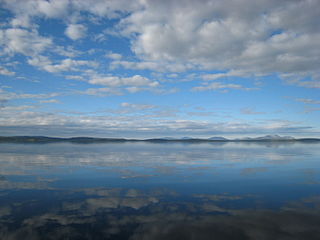
Iešjávri is a large lake in Finnmark county, Norway. The lake lies on the Finnmarksvidda plateau along the border of three municipalities: Alta, Kautokeino, and Karasjok. The lake is about 50 kilometres (31 mi) northwest of the village of Karasjok, about 30 kilometres (19 mi) northeast of the village of Masi, and about 45 kilometres (28 mi) southeast of the town of Alta.
Korssjøen is a lake in the municipality of Røros in Trøndelag county, Norway. The lake is located about 16 kilometres (9.9 mi) southeast of the town of Røros. The lake Rambergsjøen lies about 5 kilometres (3.1 mi) to the north and the lake Flensjøen lies about 10 kilometres (6.2 mi) to the east.

Finnmarksvidda is Norway's largest plateau, with an area greater than 22,000 square kilometres (8,500 sq mi). The plateau lies about 300 to 500 metres above sea level. Approximately 36% of Finnmark lies on the Finnmarksvidda.

Karasjohka (Norwegian), Kárášjohka (Northern Sami), or Kaarasjoki (Kven) is a river in Finnmark county, Norway. The 161-kilometre (100 mi) long river runs through Kautokeino Municipality and Karasjok Municipality. The river is one of the most important rivers that drains the Finnmarksvidda plateau. It flows into the famous salmon-fishing Tana River near the Finnish village of Karigasniemi on the Norway-Finland border.
Bandak is a lake in the municipalities of Kviteseid and Tokke in Telemark county, Norway. The lake, which is part of the Telemark Canal route, belongs to the Skien watershed. The river Tokke flows into the lake, and the outlet is via the river Strauman, which flows to the lake Kviteseidvatn.
Byavatnet is a lake in the municipality of Levanger in Trøndelag county, Norway. It is located about 2.5 kilometres (1.6 mi) south of the village of Ekne and about 3 kilometres (1.9 mi) west of the village of Ronglan. The lake Hammervatnet lies about 3.5 kilometres (2.2 mi) south of Byavatnet and the lake Sønningen lies about 1.5 kilometres (0.93 mi) to the northwest. The 2.31-square-kilometre (570-acre) lake is about 5 kilometres (3.1 mi) long and about 800 metres (0.5 mi) wide.
Øljusjøen is a lake in the municipalities of Hemsedal and Lærdal, Norway. The 8.45-square-kilometre (3.26 sq mi) lake is located at an elevation of 1,335 metres (4,380 ft) above sea level. It sits about 15 kilometres (9.3 mi) southeast of the village of Borgund and the European route E16 highway. The lake Eldrevatnet is 4 kilometres (2.5 mi) to the north. The lake Juklevatnet and the mountain Høgeloft are both about 12 kilometres (7.5 mi) to the northeast.

Holsavatnet is a lake which lies in the municipality of Sunnfjord in Vestland county, Norway. The lake is located about 12 kilometres (7.5 mi) east of the town of Førde and about 9.5 kilometres (5.9 mi) east of the village of Bruland. The village of Holsen lies at the eastern end of the lake. The European route E39 highway passes 3 kilometres (1.9 mi) west of the lake. The water from the lake eventually flows into the river Jølstra.
Havvannet (Norwegian) or Vuolit Áhpelanjávri (Northern Sami) is a lake in Måsøy Municipality in Finnmark county, Norway. The 3.69 square kilometres (1.42 sq mi) lake lies isolated in the mountains on the Porsanger Peninsula about 9 kilometres (5.6 mi) northeast of the village of Kokelv in Hammerfest Municipality. The lake sits at an elevation of 293-metre (961 ft) above sea level. The village of Slåtten lies about 14 kilometres (8.7 mi) northwest of the lake.
Gásadatjávri is a lake in Karasjok Municipality in Finnmark county, Norway. The 2.56-square-kilometre (0.99 sq mi) lake lies on the Finnmarksvidda plateau, about 500 metres (1,600 ft) northeast of the large lake Iešjávri in the northwestern part of the municipality.
Čorotjávri is a lake in Karasjok Municipality in Finnmark county, Norway. The 4-square-kilometre (1.5 sq mi) lake lies on the Finnmarksvidda plateau about 15 kilometres (9.3 mi) north of the small village of Šuoššjávri, just east of the municipal boundary with Kautokeino Municipality.
Mangen is a lake in the municipalities of Eidskog in Innlandet county and Aurskog-Høland in Akershus county, Norway. The 4.129-square-kilometre (1.594 sq mi) lake lies about 20 kilometres (12 mi) northeast of the village of Aursmoen and about 20 kilometres (12 mi) west of the village of Skotterud.
Nedre Roasten is a lake in Femundsmarka National Park on the border of Innlandet and Trøndelag counties in Norway. The 2.29-square-kilometre (0.88 sq mi) lake sits on the border of the municipalities of Engerdal in Innlandet county and Røros in Trøndelag county. Nedre Roasten is about 50 kilometres (31 mi) southeast of the town of Røros and just under 9 kilometres (5.6 mi) from the border with Sweden. The lake lies about 5 kilometres (3.1 mi) east of the lake Femunden and about 8 kilometres (5.0 mi) west of the lake Rogen which sits along the Swedish border.
Gákkajávri (Northern Sami) or Gaggavann (Norwegian) is a lake that lies in Porsanger Municipality in Finnmark county, Norway. The 7.4-square-kilometre (2.9 sq mi) lake lies just east of the European route E06 highway, between the villages of Lakselv and Karasjok.

(Norwegian), Kárášjohka (Northern Sami), or Kaarasjoki (Kven) is the administrative centre of Karasjok Municipality in Finnmark county, Norway. The village is located along both sides of the Karasjohka river, just 12 kilometres (7.5 mi) west of the Norway-Finland border. The European route E06 highway runs through the village on its way from Lakselv to Tana bru and Kirkenes. The 2.24-square-kilometre (550-acre) village has a population (2023) of 1,746 and a population density of 779 inhabitants per square kilometre (2,020/sq mi).
Dorvonjárga is a village in Karasjok Municipality in Finnmark county, Norway. The village is located in the eastern part of the municipality, along the Finland–Norway border. The village lies about 15 kilometres (9.3 mi) to the southeast of the village of Karasjok. The village is the site of one of the official border crossings between Norway and Finland. The border crossing goes over the Anarjohka river between Dorvonjárga and Karigasniemi in Finland.
