
Ørskog is a municipality in Møre og Romsdal county, Norway. It is part of the Sunnmøre region. The administrative centre is the village of Sjøholt. The other main village is Vaksvika, about 7.5 kilometres (4.7 mi) south of Sjøholt. The European Route E39/E136 highway runs through the municipality, connecting the towns of Ålesund and Molde. Rauma Group is the largest company in Ørskog in terms of turnover.

Sula (help·info) is a municipality in Møre og Romsdal county, Norway. It is part of the Sunnmøre district. The administrative centre is the village of Langevåg. Other villages include Solevåg, Fiskarstrand, Veibust, Leirvågen, and Mauseidvågen. Sula is one of the most densely populated municipalities in Møre og Romsdal county, and it is part of the Ålesund Region since it is just south of the city of Ålesund. The municipality encompasses the island of Sula and the many small surrounding islets.

Spjelkavik is a borough in the town of Ålesund in Ålesund Municipality, Møre og Romsdal county, Norway. It is also called "Vika" by many locals. Spjelkavik is located on the western end of the island of Uksenøya, at the intersection of the European route E39 and European route E136 highways, just west of the lake Brusdalsvatnet. The villages of Breivika, Myrland, and Løvika lie to the south of Spjelkavik. The population of Spjelkavik is approximately 11,000 inhabitants and is the second largest part of the city. It is also one of areas that grows the quickest in Ålesund. The distance from the city center of Ålesund to Spjelkavik is about 10 kilometres (6.2 mi).
Måløy is a town and the administrative centre of the municipality of Vågsøy in Sogn og Fjordane county, Norway. Måløy is located on the southeastern side of the island of Vågsøy, about 3 kilometres (1.9 mi) northeast of the village of Holvika and about 6 kilometres (3.7 mi) south of the village of Raudeberg. The Måløy Bridge connects the town centre to the area of Deknepollen on the mainland. Sør-Vågsøy Church is located in Måløy.

Ulsteinvik (help·info) is the commercial and administrative centre of the municipality (kommune) of Ulstein in Møre og Romsdal county, Norway. The 4.26-square-kilometre (1,050-acre) village has a population (2014) of 6,201; giving the village a population density of 1,456 inhabitants per square kilometre (3,770/sq mi). As such, Ulsteinvik contains 74% of the population of Ulstein Municipality. The town of Ulsteinvik is located on the west side of the island of Hareidlandet, about 23 kilometres (14 mi) southwest of the city of Ålesund. Ulstein Church is located in the town, serving the population of the whole municipality.

Nordfjordeid is the administrative centre of the municipality of Eid in Sogn og Fjordane county, western Norway. It is located at the end of the Eidsfjorden, an arm off of the main Nordfjorden, west of the large lake Hornindalsvatnet. The village of Stårheim is located about 12 kilometres (7.5 mi) to the west, the village of Mogrenda is about 5 kilometres (3.1 mi) to the east, and the village of Lote is about 7 kilometres (4.3 mi) to the southeast.

Roald is a village in Giske Municipality in Møre og Romsdal county, Norway. The village is located on the northern part of the island Vigra. Roald is about 20 kilometres (12 mi) north of the city centre of Ålesund, connected via two undersea tunnels which opened in 1987. Ålesund Airport, Vigra is 2 kilometres (1.2 mi) south of the village of Roald. Vigra Church is located a short distance south of Roald.
Myklebost or Myklebust is a village in Ålesund Municipality in Møre og Romsdal county, Norway. It is located on the south side of the island of Ellingsøya, about 4 kilometres (2.5 mi) west of the village of Årset and about 5 kilometres (3.1 mi) east of the village of Hoffland. Myklebost is about 10 kilometres (6.2 mi) northeast of the city center of Ålesund.
Hoffland or Hovland is a village in Ålesund Municipality in Møre og Romsdal county, Norway. The village is located on the western end of the island of Ellingsøya, about 3 kilometres (1.9 mi) northeast of the town of Ålesund and about 5 kilometres (3.1 mi) west of the village of Myklebost.
Fiskåbygd or Fiskå is a coastal village that is also the administrative centre of Vanylven Municipality in Møre og Romsdal county, Norway. The village is located about 100 kilometres (62 mi) southwest of the city of Ålesund, about 12 kilometres (7.5 mi) east of the village of Myklebost, and about 30 kilometres (19 mi) southwest of the village of Rovdane. Fiskåbygd lies along the shores of the Vanylvsfjorden, east of the Stadlandet peninsula in Selje Municipality.

Lysvatnet is a lake that lies in the municipality of Meløy in Nordland county, Norway. The 4.53-square-kilometre (1.75 sq mi) is located near the border with Gildeskål Municipality, about 5.5 kilometres (3.4 mi) east of the municipal centre of Ørnes. The lake Markavatnet lies about 3 kilometres (1.9 mi) to the west of this lake.

Gagnåsvatnet or Gangåsvatnet is a lake in the municipality of Orkdal in Trøndelag county, Norway. The 5.49-square-kilometre (1,360-acre) lake is located about 9 kilometres (5.6 mi) southwest of the town of Orkanger and about 6 kilometres (3.7 mi) west of the village of Fannrem in the Orkdalen valley.
Byavatnet is a lake in the municipality of Levanger in Trøndelag county, Norway. It is located about 2.5 kilometres (1.6 mi) south of the village of Ekne and about 3 kilometres (1.9 mi) west of the village of Ronglan. The lake Hammervatnet lies about 3.5 kilometres (2.2 mi) south of Byavatnet and the lake Sønningen lies about 1.5 kilometres (0.93 mi) to the northwest. The 2.31-square-kilometre (570-acre) lake is about 5 kilometres (3.1 mi) long and about 800 metres (0.5 mi) wide.
Mauseidvåg or Mauseidvågen is a village in Sula Municipality in Møre og Romsdal county, Norway. It is part of the Ålesund Region and is located about 7 kilometres (4.3 mi) southeast of the municipal center of Langevåg and about 15 kilometres (9.3 mi) south of the town of Ålesund. The Indre Sula Church is located about 1.5 kilometres (0.93 mi) east of the village of Mauseidvåg. The European route E39 highway runs just east of the village too.
Ellingsøy or Ellingsøya is the northernmost island in Ålesund Municipality in Møre og Romsdal county, Norway. With an area of 22 square kilometres (8.5 sq mi), Ellingsøy is the second largest island in the municipality after Uksenøya. The island is located northeast of the town of Ålesund, north of the islands of Nørvøya and Uksenøya, east of the island of Valderøya, and south of the mainland peninsula of Haram. The villages of Hoffland, Årset, and Myklebust are all located on the south side of the island. Ellingsøy Church is the main church for the island.

Eidsdal is a village and valley in Norddal Municipality in Møre og Romsdal county, Norway. It is located along the south side of the Norddalsfjorden, about 7 kilometres (4.3 mi) southwest of the municipal centre of Sylte and the village of Norddal lies about 4 kilometres (2.5 mi) east of Eidsdal. The local church, Norddal Church is located in nearby Norddal village. Eidsdal has approximately 400 inhabitants.

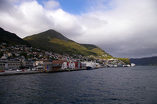
Ålesund is a town and municipality in Møre og Romsdal County, Norway. It is part of the traditional district of Sunnmøre and the centre of the Ålesund Region. It is a sea port and is noted for its concentration of Art Nouveau architecture. The town of Ålesund is the administrative centre of Ålesund Municipality, as well as the principal shipping town of the Sunnmøre district.
Årset is a village in Ålesund Municipality in Møre og Romsdal county, Norway. The village is located along the Ellingsøyfjorden on the southern shore of the island of Ellingsøya, about 4 kilometres (2.5 mi) east of the village of Myklebost and about 12 kilometres (7.5 mi) west of the village of Tennfjord in Haram Municipality.

