
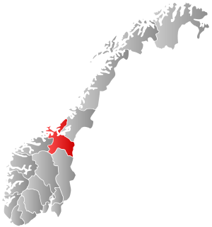
Deatnu (Northern Sami) or Tana (Norwegian) is a municipality in Finnmark county, Norway. The administrative centre of the municipality is the village of Tana bru. Other villages in the municipality include Austertana, Bonakas, Polmak, Rustefjelbma, and Skiippagurra.

Gáivuotna (Northern Sami), Kåfjord (Norwegian), or Kaivuono (Kven) is a municipality in Troms county, Norway. The administrative centre of the municipality is the village of Olderdalen. Other villages include Løkvollen, Manndalen, Birtavarre, Trollvik, Samuelsberg, Nordmannvik, and Djupvik.

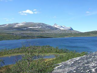
A fell is a high and barren landscape feature, such as a mountain range or moor-covered hills. The term is most often employed in Fennoscandia, the Isle of Man, parts of Northern England, and Scotland.

Alsta is an island in the municipalities of Alstahaug and Leirfjord in Nordland county, Norway. The island is surrounded by the Vefsnfjorden to the east, the Leirfjorden to the north, and the Alstenfjorden to the south and west. The eastern part of the island is dominated by the Seven Sisters mountain range which has five mountains that are more than 1,000 metres (3,300 ft) tall, while the western part of the island is relatively flat and it is the location of the town of Sandnessjøen and the village of Søvika in the south.

Ofotfjord is a fjord in Nordland county, Norway. It is an inlet of the Norwegian Sea, located about 200 kilometres (120 mi) north of the Arctic Circle. The 78-kilometre (48 mi) long Ofotfjord is Norway's 12th longest fjord and it is also the 18th deepest, with a maximum depth of 553 metres (1,814 ft). In the English language and in many historical documents, this fjord is often referred to as the Narvik Fjord because the town of Narvik is located on the inner shores of the fjord, but this is not an official name of the fjord.

Fiskeløysvatnet or Fisklausvatnet (Norwegian) or Guoledisjávrre (Lule Sami) is a lake that lies in the municipality of Saltdal in Nordland county, Norway. The 2.28-square-kilometre (0.88 sq mi) lake is located inside Junkerdal National Park, about 2 kilometres (1.2 mi) south of the border with Fauske Municipality.
Kjemåvatnet (Norwegian) or Giebbnejávrre (Lule Sami) is a lake that lies in the municipality of Saltdal in Nordland county, Norway. The 2.64-square-kilometre (1.02 sq mi) lake lies about 2 kilometres (1.2 mi) west of the village of Lønsdal.

Sørarnøy or Sør-Arnøy is a small fishing village in the municipality of Gildeskål in Nordland county, Norway. The village covers the majority of the island of Sørarnøya. The closest town to Sørarnøy is Bodø, to the north, which can be reached by boat.

Bogen (Norwegian) or Ránda (Northern Sami) is the administrative centre of Evenes Municipality in Nordland county, Norway. The village is located along the shore of the Ofotfjorden, about 10 kilometres (6.2 mi) northeast of the village of Liland. The European route E10 highway passes through the village. Bogen Chapel is located in this village.
Stoksund is a former municipality in the old Sør-Trøndelag county, Norway. The municipality existed from 1892 until its dissolution in 1964. The 114-square-kilometre (44 sq mi) municipality was located in what is now the northwestern part of the municipality of Åfjord in Trøndelag county. The municipality included the island of Stokkøya and the surrounding islets, plus the surrounding area of the mainland. The administrative centre was the village of Revsnes, where the Stoksund Church is located.

Litlmolla is an uninhabited island in Vågan Municipality in Nordland county, Norway. The island lies east of the town of Svolvær in the Vestfjorden. The island is located in the Lofoten archipelago, south of the large island of Austvågøya, southwest of the island of Stormolla, and northeast of the small island of Skrova. The 10-square-kilometre (3.9 sq mi) island was formerly inhabited, but has long since been abandoned. The highest point on the island is the 543-metre (1,781 ft) tall Nonstinden.

Cape Valdivia is the northernmost point on Bouvet Island in the South Atlantic Ocean. The subantarctic Bouvet Island is administered by Norway.

Kvesjøen is a lake in Lierne municipality in Trøndelag county, Norway. The lake lies just inside the Norwegian border with Sweden, on the west end of the lake Murusjøen. The 19.09-square-kilometre (7.37 sq mi) lake sits 320 metres (1,050 ft) above sea level. The lake contains at least six different fish species; Arctic char, burbot, two different species of trout, grayling and pike.

Storheddernuten or Storhidlernuten is a mountain on the border of Aust-Agder and Rogaland counties in southern Norway. The 1,402-metre (4,600 ft) tall mountain has a topographic prominence of 70 metres (230 ft). The mountain sits on the border of the municipalities of Suldal in Rogaland and Bykle in Aust-Agder. The mountain is the 21st highest mountain in Aust-Agder county.
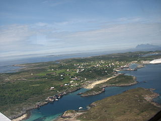
Sørarnøya or Sør-Arnøya is a small island in the municipality of Gildeskål in Nordland county, Norway. The 4-square-kilometre (1.5 sq mi) island is located west of the neighboring island of Sandhornøya and south of the island of Nordarnøya. Sørarnøya and Nordarnøya are linked with a 100-metre (330 ft) long bridge.

Beis Fjord (English) is a fjord in Narvik Municipality in Nordland county, Norway. It is a fjord arm that branches off of the main Ofotfjorden, on the south side of the town of Narvik. The Beisfjord Bridge on the European route E06 highway crosses the fjord between Ankenesstranda and Narvik. The village of Beisfjord is located at the end of the 11.5-kilometre (7.1 mi) long fjord. The maximum depth of the fjord reaches 44 metres (144 ft) below sea level.

Stormolla is an island in Vågan Municipality in Nordland county, Norway. It is located in the Lofoten islands, south of the large islands of Austvågøya and Hinnøya and northeast of the smaller islands of Litlmolla and Skrova. The highest point on the island is the 751-metre (2,464 ft) tall mountain Heggedalstinden.
Litlkorsnestinden, or Trakta, is a mountain in Hadsel Municipality in Nordland county, Norway. The 980-metre (3,220 ft) tall mountain lies on the island of Austvågøya in the Lofoten archipelago, just north of the Trollfjorden. The summit is the most difficult to reach in Norway, and requires climbing up to grade 6-. (NOR). It was first ascended in 1910 by Alf Bonnevie Bryn, Ferdinand Schjelderup and Carl Wilhelm Rubenson.

Bjøllåga or Bjellåga (Norwegian) or Biellok or Biellok-jåhkå (Lule Sami) is a river in Nordland county, Norway. It flows from the lake Nordre Bjøllåvatnet in Saltdal Municipality, through the valley of Bjøllådalen in the Saltfjellet mountains, within the Saltfjellet–Svartisen National Park, and joins with the river Ranelva in Rana Municipality.

Tenna or Kinnarøya is an island in the municipality of Herøy in Nordland county, Norway. The island has an area of 3.5 square kilometers (1.4 sq mi). It is traversed by Norwegian County Road 161, which also connects it to the neighboring island of Sør-Herøy, crossing Tennsundet over the Tennsund Bridge. To the south lies Andøysundet. The Husvær islands lie to the southwest of Tenna; they are connected to Tenna by a ferry.


