Eik is a village in Lund municipality in Rogaland county, Norway. The village is located about 9 kilometres (5.6 mi) north of the municipal centre of Moi. The small village lies in an area called Hovsherad on the north shore of the lake Hovsvatnet. The river Storåni runs through Eik.

Rogaland is a county in Western Norway, bordering the North Sea to the west and counties Vestland to the north, Vestfold og Telemark to the east and Agder to the east and southeast. In 2020, it had a population of 479,892. The administrative centre of the county is the city of Stavanger, which is one of the largest cities in Norway.

Lund is a municipality in Rogaland county, Norway. It is located in the traditional district of Dalane. The administrative centre of the municipality is the village of Moi. Other villages in Lund include Eik and, Heskestad. European route E39 and the Sørlandet Line both pass through Lund. Moi Station is a railway station in Lund.
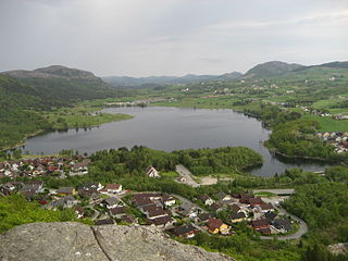
Moi is the administrative centre of Lund municipality in Rogaland county, Norway. The village is located at the northern end of the lake Lundevatnet, one of the deepest lakes in Norway. The European route E39 highway passes through Moi. The Sørlandet Line also runs through Moi, stopping at Moi Station.
Grøsfjellvatnet is a lake in Rogaland county, Norway. It is located in the municipalities of Eigersund, Lund, and Sokndal. The 3.09-square-kilometre (1.19 sq mi) lake list just north of the lake Eiavatnet, about 4 kilometres (2.5 mi) west of the village of Heskestad in Lund municipality.
Hofreistæ is a lake in the municipality of Bjerkreim in Rogaland county, Norway. The 2.66-square-kilometre (1.03 sq mi) lake immediately south of the village of Øvrebygd. The lake is fed by a short river from the lakes Austrumdalsvatnet and Byrkjelandsvatnet. The river Hofreistæåna flows south out of this lake and eventually feeds into the river Bjerkreimselva.

Oltedalsvatnet is a lake in the municipality of Gjesdal in Rogaland county, Norway. The 3.12-square-kilometre (1.20 sq mi) lake lies just south of the village of Oltedal. It is a reservoir along the river Oltedalsåna that is used to store water for the Oltedal Hydroelectric Power Station. The lake sits at an elevation of 101.5 to 112.5 metres and it holds about 28,800,000 cubic metres.
Orrevatnet is a lake in the municipality of Klepp in Rogaland county, Norway. The 8.04-square-kilometre (3.10 sq mi) lake is the largest lake in Jæren. The lake sits about 4 metres (13 ft) above sea level and it is situated along the seashore. The 500-to-2,500-metre wide sandy beach strip of land that separates the lake from the sea is home to one of Norway's longest sand beaches, Orrestranda. The village of Orre lies on this strip of land to the southeast of the lake.
Teksevatnet is a lake located on the border of the municipalities of Eigersund and Lund in Rogaland county, Norway. The 2.26 km2 (0.87 sq mi) lake lies just north of the European route E39 highway about 20 kilometres (12 mi) northeast of the town of Egersund.

Tysdalsvatnet or Tyssdalsvatnet is a lake in the municipalities of Hjelmeland and Strand in Rogaland county, Norway. The 3.74-square-kilometre (1.44 sq mi) lake lies about 5 kilometres (3.1 mi) south of the village of Årdal and about 8 kilometres (5.0 mi) east of the village of Tau. The Norwegian National Road 13 (Rv13) runs along the northern side of the lake. The Svo Tunnel was completed in 2013 and it routes much of Rv13 through a mountain rather than along the narrow shoreline of the lake.
Vatsvatnet is a lake in the municipality of Vindafjord in Rogaland county, Norway. The 2.16-square-kilometre (0.83 sq mi) lake lies south of the European route E134 highway and north of the village of Vats. The long, narrow lake is 5.8 kilometres (3.6 mi) long, and has a maximum width of 900 metres (3,000 ft). The primary outflow of the lake is the river Åmselva which flows south into the Vatsfjorden.
Ørsdalsvatnet or Ørdalsvatnet is a lake in the municipality of Bjerkreim in Rogaland county, Norway. The 12.22-square-kilometre (4.72 sq mi) lake lies about 2 kilometres (1.2 mi) northeast of the village of Bjerkreim. The lake is rather narrow, but it is 15 kilometres (9.3 mi) long.

Aksdalsvatnet is a lake in the municipality of Tysvær in Rogaland county, Norway. The 3.46-square-kilometre (1.34 sq mi) lake lies southeast of the village of Førre and south of the village of Aksdal. The European route E134 highway runs along the northern shore of the lake and the European route E39 highway runs along the eastern shore of the lake.
Byrkjelandsvatnet or Storavatnet is a lake in the municipality of Bjerkreim in Rogaland county, Norway. The 5.17-square-kilometre (2.00 sq mi) lake lies about 2 kilometres (1.2 mi) north of the village of Øvrebygd. The lake flows out through the short river Malmeisåna which flows into the lake Hofreistæ.
Vigdarvatnet is a lake in the municipality of Sveio in Vestland county, Norway. A small arm off the main lake juts to the south and runs along the municipal-county border between Sveio in Vestland county and the town of Haugesund in Rogaland county. The 10-kilometre (6.2 mi) long lake forms a U-shape. It is fed by the nearby lake Stakkastadvatnet to the south, and it empties into the Ålfjorden, a small fjord arm off the main Hardangerfjorden. The village of Sveio lies on the northwestern shore of the lake.
Lundevatn, or Lundevatnet, is a lake on the borders between the municipalities of Lund and Flekkefjord in Norway. The village of Moi lies at the northern end of the lake and the smaller village of Åna-Sira lies just south of the southern end of the lake. The lake has a small dam at the southern end and it is used for the nearby Åna-Sira Power Station.

Heskestad is a village in Lund municipality in Rogaland county, Norway. The village is located in the western part of Lund, along the European route E39 highway and the Sørlandet Line, about 15 kilometres (9.3 mi) northwest of the village of Moi. Heskestad Station is a now-closed railway station located in the village.
Frøylandsvatnet is a lake in the municipality of Sandnes in Rogaland county, Norway. The 0.48-square-kilometre (120-acre) lake lies on the south side of the village of Hommersåk, about 10 kilometres (6.2 mi) northeast of the city of Sandnes. The lake empties into a small river that runs out of the north end of the lake. The river runs through Hommersåk into an arm of the Gandsfjorden.
Stakkastadvatnet is a lake on the border of Rogaland and Vestland counties in Norway. The 2.92-square-kilometre (1.13 sq mi) lake mostly lies in Rogaland along the municipal borders of Haugesund and Tysvær. A very small portion of the northern part of the lake crosses over into the municipality of Sveio in Vestland county. The lake lies about 6 kilometres (3.7 mi) northeast of the town of Haugesund. The lake has a small dam on the northwestern edge of the lake. The natural outlet of the lake flows through the dam and into the nearby lake Vigdarvatnet, located to the north.
Edlandsvatnet is a lake in the municipality of Gjesdal in Rogaland county, Norway. The 2.11-square-kilometre (0.81 sq mi) lake lies just south of the large village of Ålgård, immediately southwest of the lake Limavatnet. The European route E39 highway runs along the northern shore of the lake. The lake empties into the river Figgjoelva on the northwestern end of the lake. The lake has many brown trout in it.

