Buskerud is a county and a current electoral district in Norway, bordering Akershus, Oslo, Oppland, Sogn og Fjordane, Hordaland, Telemark and Vestfold. The region extends from the Oslofjord and Drammensfjorden in the southeast to Hardangervidda mountain range in the northwest. The county administration was in modern times located in Drammen. Buskerud was merged with Akershus and Østfold into the newly created Viken County on 1 January 2020. On the 23 February 2022 Viken County Council voted in a 49 against 38 decision to submit an application to the Norwegian government for a county demerger. Due to this, Buskerud was re-established in 2024.

Nore og Uvdal is a municipality in Buskerud county, Norway. It is part of the traditional region of Numedal. The administrative centre of the municipality is the village of Rødberg.

Hol is a municipality in Buskerud county, Norway.

Rollag is a municipality in Buskerud county, Norway. It is part of the traditional region of Numedal. The administrative centre of the municipality is the village of Rollag, although the most populated area in the municipality is Veggli. Rollag is bordered in the north by Nore og Uvdal, in the east by Sigdal, in the south by Flesberg, and in the west by Tinn in Telemark.
Numedal is a valley and a traditional district in Eastern Norway located within the county of Buskerud. It traditionally includes the municipalities Flesberg, Nore og Uvdal and Rollag. Administratively, it now also includes Kongsberg.
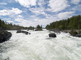
Numedalslågen is a river in Norway. It is considered to be the second longest river in Southern Norway. It is located in the Numedal valley which runs through the counties of Vestfold, Buskerud and Vestland. At 356 kilometres (221 mi) long, it is of the longest rivers in Norway.

Nore Stave Church is a stave church located at Nore in Nore og Uvdal kommune in Buskerud county, Norway.
Nore is a village in the municipality of Nore og Uvdal in the county of Buskerud, Norway. It is located in the traditional region of Numedal.

Uvdal is a village and former municipality in Buskerud county, Norway. It is situated in the traditional region of Numedal and is the location of the Uvdal Stave Church.
Tinnhølen or Tinnhylen is a lake in Norway that lies in the municipality of Eidfjord in Vestland county and a very small part crosses into the municipality of Nore og Uvdal in Buskerud county. The lake lies just inside Hardangervidda National Park on the vast Hardangervidda plateau. The northern part of the lake is accessible by road.
Halnefjorden is a large lake on the border of Vestland and Buskerud counties in Norway. It is located in the municipalities of Hol and Nore og Uvdal in Viken county and in Eidfjord municipality in Vestland county. At 13.61 square kilometres (5.25 sq mi), it is among the largest lakes located on the vast Hardangervidda plateau. The Norwegian National Road 7 runs along the northern shore of the lake, and that is the only road access to the lake. The lake is one of the headwaters of the river Numedalslågen.
Skaupsjøen is a lake in the municipalities of Eidfjord in Vestland county and Nore og Uvdal in Buskerud county, Norway. The 2.88-square-kilometre (1.11 sq mi) lake lies just north of the Hardangervidda National Park on the vast Hardangervidda plateau. The lake outflows to the river Skaupa, which flows into the larger lake Halnefjorden to the northeast. The nearest road access is the Norwegian National Road 7, which passes about 5 kilometres (3.1 mi) northwest of the lake.
Bjornesfjorden is a lake in the municipality of Nore og Uvdal in Buskerud county, Norway. It lies at 1,223 meters above sea level. It is drained by the Numedalslågen. Bjornesfjorden is situated in the Hardangervidda plateau and lies within the Hardangervidda National Park.
Kravikfjorden is a lake in the municipality of Nore og Uvdal in Buskerud county, Norway. It is a part of Numedalslågen.
Langesjøen is a lake in the municipality of Nore og Uvdal in Buskerud, Norway. Langesjøen is located ln Hardangervidda. Djupa flows out of Langesjøen to form part of the Numedalslågen watershed (Numedalsvassdraget).

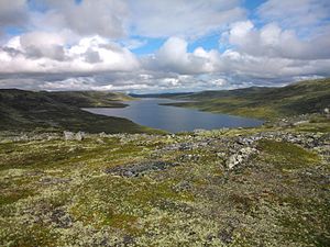
Norefjorden is a lake in the municipality of Nore og Uvdal in Buskerud, Norway. Norefjorden is a long, narrow mountain lake which is known for its fishing. Numedalslågen flows into the far north and exits travelling southward to Kravikfjorden. Norefjord bridge goes across the lake between Norefjord and Gvåle. The surrounding terrain is steep and forested.
Øvre Hein is a lake in the municipalities of Nore og Uvdal and Hol in Buskerud county, Norway. The lake is located in the eastern Hardangervidda and lies partly in the Hardangervidda National Park.

Rødungen is a lake in Buskerud County, Norway. The lake is located on the border between the municipalities of Ål and Nore og Uvdal. Waterfall from the lake is a power source for Usta kraftverk, a hydro-electric plant. The power station exploits the fall of the Usta River from Rødungen as well as Ustevatn. The plant started production in 1965 and is owned and operated by E- CO Energi.
Geitsjøen is a lake in the municipality of Nore og Uvdal in Buskerud, Norway. It lies east of the Hardangervidda mountain plateau, at the lower end of the catchment area of the river Djupa in the Numedalslågen watershed.
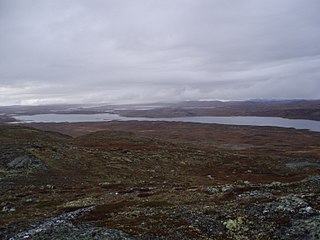
Tunhovdfjorden is a lake in the Nore og Uvdal municipality in Viken county, Norway. It has an area of 25.30 km² and a circumference of 62.79 km. It is part of the Numedalslågen watershed. Tunhovdfjorden is known for its trout and is popular for ice fishing.