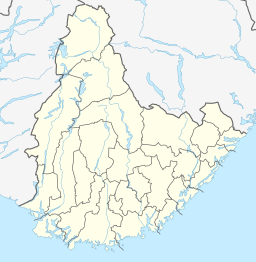
The Otra is the largest river in the Sørlandet region of Norway. It begins in Setesdalsheiene mountains at the lake Breidvatnet in Bykle municipality in Agder county, just south of the border with Vinje municipality in Vestfold og Telemark county. The river then flows south through Bykle, Valle, Bygland, Evje og Hornnes, Iveland, Vennesla, and Kristiansand municipalities. The river empties into the Skagerrak in the center of the city of Kristiansand on the southern coast of Norway.
Ormsavatnet is a lake in the municipality of Bykle in Agder county, Norway. The 3.11-square-kilometre (1.20 sq mi) lake flows into the Vatndalsvatnet via a dam and canal. The lake is located in the Setesdalsheiene mountains near the lakes Store Urevatn, Holmevatnet, and Hartevatnet. The nearest village area is Hovden, about 14 kilometres (8.7 mi) to the northeast. The mountain Kaldafjellet lies about 5 kilometres (3.1 mi) to the west of the lake.
Reinevatn is a lake in the municipality of Bykle in Agder county, Norway. The 2.86-square-kilometre (1.10 sq mi) lake is located south of the lakes Store Urevatn and Vatndalsvatnet in the Setesdalsheiene mountains in the Setesdal valley, about 10 kilometres (6.2 mi) northwest of the village of Bykle. The lake has a dam on the southern edge which keeps the water level at an elevation of 1,170 metres (3,840 ft) above sea level. The dam's spillway flows into the nearby river Skargjesåni. The Snjoheinuten mountain lies just to the northeast of the lake.

Rosskreppfjorden is a lake in Norway. The 29.51-square-kilometre (11.39 sq mi) lake lies on the border between the municipalities of Valle and Sirdal in Agder county. The lake is part of the Kvina river system and has a hydroelectric power plant in a dam on the south end of the lake. The dam keeps the lake at an elevation of about 929 to 890 metres above sea level.

Hartevatnet or Hartevatn is a lake in the municipality of Bykle in Agder county, Norway. It is located along the river Otra, on the south side of the village of Hovden. The lake is a good fishing spot and contains many brown trout. The Norwegian National Road 9 runs along the eastern shore of the lake. The lake Skyvatn lies about 6 kilometres (3.7 mi) to the northwest and the lake Holmavatnet lies about 13 kilometres (8.1 mi) to the northwest.

Herefossfjorden is a lake in the municipality of Birkenes in Agder county, Norway. The 3.7-square-kilometre (1.4 sq mi) lake is about 9 kilometres (5.6 mi) long and it is part of the Tovdalselva river. The Gauslåfjorden and Uldalsåna lakes flow into Herefossfjorden near the village of Herefoss at the northern end of the lake. The Uldalsåna lake is held back by a dam and the Gauslåfjorden flows over a waterfall into the Herefossfjorden. The Norwegian National Road 41 runs along the eastern shore. The village of Herefoss lies on the northern edge of the lake and the village of Søre Herefoss lies at the southern end of the fjord. The old municipality of Herefoss existed from 1838 until 1967 and it included all the land surrounding the lake.
Holmavatnet is a lake the Setesdalsheiene mountains of Southern Norway. It is located on the border of the municipalities of Suldal, Vinje, and a small part in Bykle. The southeastern corner of the lake is in Bykle, and it is the northernmost part of all of Aust-Agder county. The lake Skyvatn is located about 5 kilometres (3.1 mi) to the south of the lake.
Holmevatnet or Holmevatn is a lake in the Setesdalsheiene area of Norway. It is located in the mountains on the border of the municipalities of Bykle in Agder county and Suldal in Rogaland county. The 4.76-square-kilometre (1.84 sq mi) lake lies just west of the lake Store Urevatn and to the northeast of the lake Blåsjø. The nearest villages are Berdalen in Bykle, about 20 kilometres (12 mi) to the east and Suldalsosen, about 30 kilometres (19 mi) to the west. The mountain Kaldafjellet lies about 6 kilometres (3.7 mi) north of the lake.
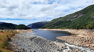
Botsvatn or Bossvatn is a lake in the municipality of Bykle in Agder county, Norway. The 14.6-kilometre (9.1 mi) long, narrow reservoir is located just to the southeast of the large lake Blåsjø and northeast of the lake Ytre Storevatnet. The lake holds water for the Brokke Hydroelectric Power Station, located in nearby Valle municipality. The water from the lake can flow out into the nearby river Otra, but only when water is released from the dam.
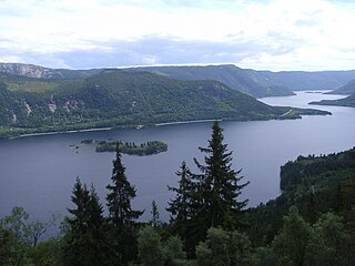
Byglandsfjorden is a lake in Agder county, Norway. The 32.79-square-kilometre (12.66 sq mi) lake lies on the river Otra, primarily in the municipality of Bygland, but the far southern tip of the lake extends into the neighboring municipality of Evje og Hornnes. The river flows out of the lake Åraksfjorden to the north and into the Byglandsfjorden through a narrow channel, and the southern end of the Byglandsfjorden is marked by a dam along the river. The villages of Byglandsfjord, Grendi, Longerak, Lauvdal, and Bygland are all located on the eastern shore of the lake along the Norwegian National Road 9. The western shore of the lake is much more sparsely populated, with County Road 304 following that shoreline.
Store Urevatn or Urevatn is a lake in the municipality of Bykle in Agder county, Norway. The 14.61-square-kilometre (5.64 sq mi) lake lies about 13 kilometres (8.1 mi) west of the village of Hoslemo and about 15 kilometres (9.3 mi) northwest of the municipal centre of Bykle. The lake sits at an elevation of 1,164 metres (3,819 ft) above sea level, high up in the Setesdalsheiene mountains, just north of the mountains Urevassnutene and Djuptjønnuten and just west of Snjoheinuten.
Gravatnet is a lake in the municipality of Sirdal in Agder county, Norway. The 5.33-square-kilometre (2.06 sq mi) lake is located about 9 kilometres (5.6 mi) north of the small village of Lunde. The lake lies immediately south of the lake Valevatn, which flows out into Gravatnet. The water in Gravatnet is stopped by a dam on the south side. The water is regulated at an elevation of 660 metres (2,170 ft) and it flows out through the small river Gravassåni which is a tributary of the big river Sira.
Ytre Storevatnet is a lake in the municipality of Bykle in Agder county, Norway. The 2.8-square-kilometre (1.1 sq mi) lake makes up the northernmost part of the Svartevatnet reservoir that empties into the Sira River system. The lake is located just south of the lake Blåsjø and southwest of Botsvatn. The village of Bykle is about 25 kilometres (16 mi) northeast of the lake.
Nordbygdi is a village in the municipality of Bykle in Agder county, Norway. It is located in the Setesdalen valley along the northeastern shore of the lake, Botsvatn. The village is located about 1 kilometre (0.62 mi) west of the village of Bykle and the river Otra, and about 7 kilometres (4.3 mi) south of the lake Reinevatn.
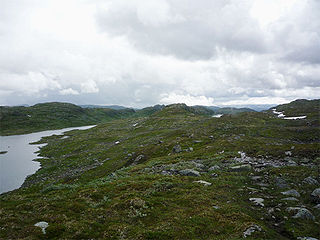
Setesdalsheiene is the collective term for the mountains to the west and east of the Setesdalen valley in Agder county in Southern Norway. The river Otra flows through the valley between the mountains. This area is primarily located in the municipalities of Bykle, Valle, Bygland, Evje og Hornnes, Sirdal, Kvinesdal, and Åseral. The vast Hardangervidda plateau lies to the north and the Ryfylkeheiene mountains lie to the west.
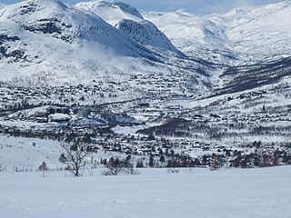
Hovden is a village in the municipality of Bykle in Agder county, Norway. It is located in the northern part of Setesdalen valley, on the Norwegian National Road 9 and the river Otra, on the eastern shore of the lake Hartevatnet. The village sits about 25 kilometres (16 mi) north of the village of Bykle and about 4 kilometres (2.5 mi) east of the village of Breive. The 0.57-square-kilometre (140-acre) village has a population (2019) of 413 and a population density of 726 inhabitants per square kilometre (1,880/sq mi). Fjellgardane Church is located in Hovden.
Brandsnutene or Brandsnutane is a 1,496-metre (4,908 ft) tall mountain on the border of Agder and Vestfold og Telemark counties in southern Norway. It is the second highest mountain in Agder of the mountains with a prominence of at least 50 metres (160 ft). The mountain is located on the border of the municipalities of Bykle and Tokke. The mountain has a secondary peak of 1,480 metres (4,860 ft) located about 1 kilometre (0.62 mi) east of the municipal/county border inside Tokke.
Berdalen is a village in Bykle municipality in Agder county, Norway. The village is located in the Setesdalen valley, along the river Otra and the Norwegian National Road 9. It is about 12 kilometres (7.5 mi) north of the village of Bykle and the same distance south of the village of Hovden. The small village of Hoslemo and the lake Vatndalsvatnet both lie about 3 kilometres (1.9 mi) to the west of the village. Berdalen has several large mountains located about 10 kilometres (6.2 mi) to the east along the municipal border. The mountains include Gråsteinsnosi, Brandsnutene, Svolhusgreini, Sæbyggjenuten, and Støylsdalsnutene.
Hoslemo is a village in Bykle municipality in Agder county, Norway. The village is located in the Setesdalen valley, along the river Otra and the Norwegian National Road 9. It is about 10 kilometres (6.2 mi) north of the village of Bykle and about 16 kilometres (9.9 mi) south of the village of Hovden. The small village of Berdalen lies about 3 kilometres (1.9 mi) northeast of Hoslemo. The lake Vatndalsvatnet lies about 3 kilometres (1.9 mi) to the north of the village. The mountains Kvervetjønnuten and Snjoheinuten lie to the west of the village.

Bykle or Bykle Kyrkjebygd is the administrative centre of Bykle municipality in Agder county, Norway. The village is located along the river Otra and the Norwegian National Road 9 in the southern part of the municipality. It is located about 5 kilometres (3.1 mi) east of the small village of Nordbygdi. The villages of Hoslemo and Berdalen lie about 10 kilometres (6.2 mi) to the north.
