
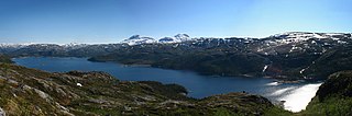
Altevatnet (Norwegian) or Álddesjávri (Northern Sami) is Norway’s 11th largest lake. The 79.71-square-kilometre (30.78 sq mi) lake lies in the Bardu Municipality in Troms county, Norway.
Faulvatnet (Norwegian) or Låddejávrre (Lule Sami) is a lake that lies in the municipality of Sørfold in Nordland county, Norway. The 7.24-square-kilometre (2.80 sq mi) lake is located about 15 kilometres (9.3 mi) north of the village of Straumen, just west of Rago National Park. The water flows out into the Sleipdalselva river and the water is used for power generation at the Lakshola hydroelectric power station.
Hundålvatnet is a lake that lies in the municipality of Vefsn in Nordland county, Norway. The 7.96-square-kilometre (3.07 sq mi) lake lies in the western part of the municipality, about 12 kilometres (7.5 mi) west of the town of Mosjøen. It is located just north of the Lomsdal–Visten National Park. The lake flows into the Hundåla river which flows north into the Vefsnfjorden.
Kjelvatnet (Norwegian) or Giebbnejávrre or Giebnejávri (Lule Sami) is a lake in Fauske Municipality in Nordland county, Norway. The 3.85-square-kilometre (1.49 sq mi) lake lies about 7 kilometres (4.3 mi) south of the village of Sulitjelma near the border with Junkerdal National Park. Water flows into the lake from the large lake Balvatnet and it flows out of the lake to the north along the Balmi River to the lake Langvatnet.
Nordre Bjøllåvatnet (Norwegian) or Bajep Ruovdajávrre (Lule Sami) is a lake that lies in the municipality of Saltdal in Nordland county, Norway. The 9.93-square-kilometre (3.83 sq mi) lake is located inside Saltfjellet–Svartisen National Park, about 1 kilometre (0.62 mi) east of the border with the municipality of Beiarn and north of the border with the municipality of Rana. The lake flows out through the river Bjøllåga and ultimately into the river Ranelva.
Stormyrbassenget, also known as Stormyraven or Avan, is a lake in the municipality of Hemnes in Nordland county, Norway. It lies about 12 kilometres (7.5 mi) south of the municipal center of Korgen and about 4 kilometres (2.5 mi) north of the village of Bleikvasslia. The lake lies along the river Røssåga as it flows north to the Ranfjord.
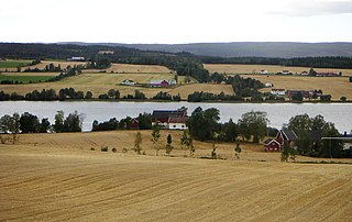
Einavatnet is a lake which lies in Vestre Toten Municipality in Innlandet county, Norway. The 13.82-square-kilometre (5.34 sq mi) lake lies at an elevation of 398 metres (1,306 ft) above sea level. The lake lies in the southern portion of the municipality, about 12 kilometres (7.5 mi) south of the municipal centre, Raufoss. The village of Eina lies at the northern end of the lake. The Eina Church is located on the eastern shore of the lake. The Norwegian National Road 4 runs along the eastern shore of the lake. The river Hunnselva flows north out of the lake towards the town of Gjøvik where it drains into the large lake Mjøsa.
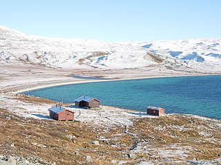
Iešjávri is a large lake on the border of the three municipalities of Alta, Kautokeino, and Karasjok in Finnmark county, Norway. The lake lies on the Finnmarksvidda plateau about 50 kilometres (31 mi) northwest of the village of Karasjok, about 30 kilometres (19 mi) northeast of the village of Masi, and about 45 kilometres (28 mi) southeast of the town of Alta.
Nesjøen is an artificial lake (reservoir) in the municipality of Tydal in Trøndelag county, Norway. The lake is part of the Nea-Nidelv watershed which lies on the western part of the Sylan mountain range. The lake lies about 10 kilometres (6.2 mi) southeast of the municipal center of Ås and 6.5 kilometres (4.0 mi) north of the village of Stugudalen. The lake is good for trout fishing.
Rien is a lake in the municipality of Røros in Trøndelag county, Norway. The 14.87-square-kilometre (5.74 sq mi) lake is located near the headwaters of the river Glomma, only about 10 kilometres (6.2 mi) west of the border with Sweden. The water flows out through the river Glomma and heads a short distance south, into the large lake Aursunden. The village of Brekken lies about 6 kilometres (3.7 mi) south of the lake and the town of Røros lies about 40 kilometres (25 mi) to the southwest.
Botsvatn or Bossvatn is a lake in the municipality of Bykle in Agder county, Norway. The 14.6-kilometre (9.1 mi) long, narrow reservoir is located just to the southeast of the large lake Blåsjø and northeast of the lake Ytre Storevatnet. The lake holds water for the Brokke Hydroelectric Power Station, located in nearby Valle municipality. The water from the lake can flow out into the nearby river Otra, but only when water is released from the dam.
Feren or Færen is a lake in the municipality of Meråker in Trøndelag county, Norway. A small part in the northwestern corner of the lake extends into the municipalities of Stjørdal, Levanger, and Verdal at the outlet into the river Forra. The 26-square-kilometre (10 sq mi) lake lies about 14 kilometres (8.7 mi) north of the municipal center of Midtbygda, about 2.5 kilometres (1.6 mi) north of the lake Funnsjøen, and about 8 kilometres (5.0 mi) north of the lake Fjergen.
Fjergen is a lake in the municipality of Meråker in Trøndelag county, Norway. The 14.41-square-kilometre (5.56 sq mi) lake has a hydropower dam on the southern end which flows out into the Kåpperåa river which is part of the Stjørdalselva river system. There is about 204,000,000 cubic metres (7.2×10⁹ cu ft) of water stored in the lake.

Aursunden or Aursund is a lake in the municipality of Røros in Trøndelag county, Norway. The village of Brekken lies along the eastern shore and the village of Glåmos lies along the western shore.

Dingevatn or Dingevatnet is the 18th deepest lake in Norway, reaching a maximum depth of 220 metres (720 ft). It is located in the municipality of Gulen in Vestland county. The 2.84-square-kilometre (1.10 sq mi) lake is located just east of the village of Dingja, about 1 kilometre (0.62 mi) southeast of the mouth of the Sognefjorden. The lake lies about 4 kilometres (2.5 mi) north of the municipal center of Eivindvik. The lake flows out into the small Dingjaelva river, which runs past the village of Dingja before emptying into the Sognesjøen strait.
Samsjøen is a lake in Trøndelag county, Norway. The 10-square-kilometre (3.9 sq mi) lake sits on the border of the municipalities of Midtre Gauldal and Melhus. Most of the lake lies in Midtre Gauldal, about 12 kilometres (7.5 mi) north of the village of Singsås. The lake has a dam at the northwest end, which is used for hydroelectric power production. The water flows out of the lake and into the Lundesokna river which flows into the river Gaula.

Klistervatnet is a lake that lies on the border between Norway and Russia. The 17.2-square-kilometre (6.6 sq mi) lake lies on the river Pasvikelva and it is about 10 kilometres (6.2 mi) long and 2 kilometres (1.2 mi) wide. The lake is located north of lake Bjørnevatnet.
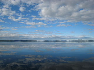
Storsjøen is a lake in the Odalen valley in Innlandet county, Norway. The 42.8-square-kilometre (16.5 sq mi) lake straddles the municipal boundary between Sør-Odal Municipality and Nord-Odal Municipality. The lake lies just south of the village of Sand and just north of the village of Skarnes.
Langavatnet is a lake in Ullensvang Municipality in Vestland county, Norway. The 6.19-square-kilometre (2.39 sq mi) lake lies about 10 kilometres (6.2 mi) straight east of the town of Odda. The lake has a dam at the north end to regulate the water level for the purposes of hydroelectric power generation. The water of the lake previously flowed north to create the large Ringedalsfossen waterfall which now only flows when the lake gets too full. The water flows over the falls into the lake Ringedalsvatnet before flowing through the short river Tysso which empties into the Sørfjorden.
Kalhovdfjorden is a lake in Tinn Municipality in Telemark county, Norway. The lake lies about 20 kilometres (12 mi) to the north of the town of Rjukan and about 15 kilometres (9.3 mi) east of the Hardangervidda National Park. The lake is part of the Skien watershed. The river Mår is the main outflow of the lake. The lake Møsvatn lies to the southwest and the lake Tinnsjå lies to the southeast. The area of the lake is 20.39 square kilometers (7.87 sq mi) and it is located 1,084 meters (3,556 ft) above sea level.

