Malvik is a municipality in Trøndelag county, Norway. It is part of the Trondheim Region. The administrative center of the municipality is the village of Hommelvik. Other villages in Malvik include Muruvika, Smiskaret, Sneisen, Vikhammer, and Hundhammeren.

Selbu is a municipality in Trøndelag county, Norway. The administrative centre of the municipality is the village of Mebonden. Other villages in Selbu include Flora, Fossan, Hyttbakken, Innbygda, Selbustrand, Trøa, Tømra, and Vikvarvet.

Hegra is a village in the municipality of Stjørdal in Trøndelag county, Norway. The village is located in the Stjørdalen valley, about 10 kilometres (6.2 mi) east of the town of Stjørdalshalsen along the Stjørdalselva river and it is therefore a good site for fishing. The 0.41-square-kilometre (100-acre) village has a population (2018) of 524 and a population density of 1,278 inhabitants per square kilometre (3,310/sq mi).

Verdalsøra is a town in the municipality of Verdal in Trøndelag county, Norway. The town is the administrative center of the municipality. It is located along the Trondheimsfjord at the mouth of the river Verdalselva. The village of Vinne lies 4 kilometres (2.5 mi) to the southeast, Trones lies about 5 kilometres (3.1 mi) to the north, the villages of Forbregd/Lein lie about 4 kilometres (2.5 mi) to the northeast, and the village of Stiklestad lies about 3 kilometres (1.9 mi) to the east. In 1998, the municipal council of Verdal voted to grant the urban area of Verdalsøra town status under the laws of Norway.
Kopperå is a village in the municipality of Meråker in Trøndelag county, Norway. The village lies about 7 kilometres (4.3 mi) east of the municipal center of Midtbygda and about 14 kilometres (8.7 mi) west of the Swedish border. The Meråker Line railway runs through the village and stops at the Kopperå Station. The village sits near the confluence of the rivers Kåpperåa and Stjørdalselva, and it is about 5 kilometres (3.1 mi) south of the lake Fjergen. The local Kopperå Chapel sits on the northwest edge of the village.

Vanvikan is a village in the municipality of Indre Fosen in Trøndelag county, Norway. It is located along the Trondheimsfjord in the southeastern part of the municipality. The village of Seter lies about 10 kilometres (6.2 mi) northeast of Vanvikan and the lake Storvatnet lies about 4 kilometres (2.5 mi) north of the village. One of the schools in the municipality, Vanvikan Skole is located in the village of Vanvikan. Stranda Church is also located in the village.
Muruvika or Muruvik is a village in the municipality of Malvik in Trøndelag county, Norway. The village is located near the end of the Stjørdalsfjorden, an arm of the Trondheimsfjord. The village sits about 3 kilometres (1.9 mi) north of the village of Hommelvik, the municipal centre.
Feren or Færen is a lake in the municipality of Meråker in Trøndelag county, Norway. A small part in the northwestern corner of the lake extends into the municipalities of Stjørdal, Levanger, and Verdal at the outlet into the river Forra. The 26-square-kilometre (10 sq mi) lake lies about 14 kilometres (8.7 mi) north of the municipal center of Midtbygda, about 2.5 kilometres (1.6 mi) north of the lake Funnsjøen, and about 8 kilometres (5.0 mi) north of the lake Fjergen.
Fjergen is a lake in the municipality of Meråker in Trøndelag county, Norway. The 14.41-square-kilometre (5.56 sq mi) lake has a hydropower dam on the southern end which flows out into the Kåpperåa river which is part of the Stjørdalselva river system. There is about 204,000,000 cubic metres (7.2×10⁹ cu ft) of water stored in the lake.
Funnsjøen is a lake in the municipality of Meråker in Trøndelag county, Norway. The 8-square-kilometre (3.1 sq mi) lake flows into the Funna river, a part of the Stjørdalselva river system. The lake has a hydropower dam at the southern end of the lake. There is about 64,000,000 cubic metres (84,000,000 cu yd) of water stored behind the dame in the lake.
Trolla is a village in the municipality of Trondheim in Trøndelag county, Norway. It is located in the Midtbyen borough, along the Trondheimsfjord on the north coast of the Bymarka area. It is about 10 kilometres (6.2 mi) northeast of the village of Langørjan and about 4 kilometres (2.5 mi) northwest of the Ila neighborhood in the city of Trondheim.

Fongen (Norwegian) or Lopmesvaerie (Southern Sami) is a mountain in Trøndelag county, Norway. The mountain sits along the border of the municipalities of Selbu, Tydal, and Meråker. The 1,441-metre (4,728 ft) summit is located inside the Skarvan and Roltdalen National Park. The nearest villages are Mebonden in Selbu, about 25 kilometres (16 mi) to the southwest, Ås in Tydal, about 32 kilometres (20 mi) to the southeast, and the village of Midtbygda in Meråker. The closest Norwegian Trekking Association cabin is Ramsjøhytta, several kilometers to the east of the summit.
Gudåa or Gudå is a village in the municipality of Meråker in Trøndelag county, Norway. It is located along the river Stjørdalselva, about 7.5 kilometres (4.7 mi) west of the municipal center of Midtbygda. The village is served by Gudå Station on the Meråker Line railway as well as the European route E14 highway. Gudåa has a camping ground and it is a popular fishing spot for salmon.

Meråker Station is a railway station on the Meråker Line in the village of Midtbygda in the municipality of Meråker in Trøndelag county, Norway. The station was opened on 17 October 1881 as Meraker, and received the current name on 1 June 1919.
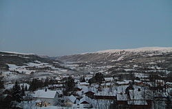
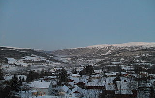
Stordalen or Stordal is a village in the municipality of Meråker in Trøndelag county, Norway. It is located in the Dalådalen valley about 14 kilometres (8.7 mi) southeast of the municipal center of Midtbygda. It is the location of Stordalen Chapel.

Meråker Church is a parish church of the Church of Norway in Meråker municipality in Trøndelag county, Norway. It is located just northwest of the village of Midtbygda. It is the main church for the Meråker parish which is part of the Stjørdal prosti (deanery) in the Diocese of Nidaros. The white, wooden church was built in a long church style in 1793 by the architects P. Olsen and E. Nanstad. The church seats about 320 people.
Flornes is a village in the municipality of Stjørdal in Trøndelag county, Norway. It is located in the western part of the municipality along the Stjørdalselva river, about 25 kilometres (16 mi) east of the town of Stjørdalshalsen. The village of Sona lies to the west and the village of Gudå lies to the east.
Stjørdalen is a former municipality in the old Nordre Trondhjem county in Norway. The 2,253-square-kilometre (870 sq mi) municipality existed from 1838 until its dissolution in 1850. The municipality covered the whole Stjørdalen valley in what is now the municipalities of Stjørdal and Meråker in Trøndelag county. The administrative centre was located at Værnes where Værnes Church is located.

Hegra is a former municipality in the old Nord-Trøndelag county, Norway. The 612-square-kilometre (236 sq mi) municipality existed from 1874 until its dissolution in 1962. The municipality was located in the Stjørdalen valley. It encompassed the eastern two-thirds of the what is now the municipality of Stjørdal in Trøndelag county. The administrative centre was the village of Hegra where the Hegra Church is located.