
Steinkjer is a municipality in Trøndelag county, Norway. It is part of the Innherad region. The administrative centre of the municipality is the town of Steinkjer which is located on the inner part of the Trondheimsfjord. The town is also the administrative centre for Trøndelag county. Other populated areas in Steinkjer include the villages of Ogndal, Hyllbrua, Gaulstad, Beitstad, Bartnes, Vellamelen, Stod, Binde, Sunnan, Byafossen, Følling, Kvam, Lerkehaug, Mære, Sparbu, Vassaunet, Vekre, Malm, Follafoss, Sela, and Verrastranda.

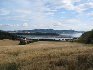
Snåsavatnet is Norway's sixth-largest lake. The 126-square-kilometre (49 sq mi) lake is located in Steinkjer Municipality and Snåsa Municipality in Trøndelag county, Norway. The villages of Følling and Sunnan lie at the southwestern end of the lake and the village of Snåsa lies at the northeastern end of the lake. European route E6 runs along the northern shore of the lake and the Nordland Line railway runs along the southern shore.
Fossemvatnet is a lake in Steinkjer Municipality in Trøndelag county, Norway.
Gilten is a lake in Trøndelag county, Norway. The lake lies mostly in Steinkjer Municipality, and a small part crossing into neighboring Namsos Municipality. The 31.62-square-kilometre (12.21 sq mi) lake lies in the northern part of Steinkjer Municipality, about 8 kilometres (5.0 mi) northeast of the village of Kvam, about 1.5 kilometres (0.93 mi) north of the village of Følling, and about 14 kilometres (8.7 mi) east of the village of Namdalseid. The lake is only accessible by road in Namsos Municipality, even though most of the 31.62-square-kilometre (12.21 sq mi) lake lies in Steinkjer Municipality. The lake Bangsjøan lies to the northeast and the lake Snåsavatnet lies to the south.
Holden is a lake in Steinkjer Municipality in Trøndelag county, Norway. It is located about 8 kilometres (5.0 mi) west of the village of Malm and about 10 kilometres (6.2 mi) north of the village of Follafoss. The 13.31-square-kilometre (5.14 sq mi) lake has a dam on the southern end to control the water for hydroelectric power. The lake flows out into the Follaelva river which flows into the Trondheimsfjord at the village of Follafoss.

Ormsetvatnet is a lake in Steinkjer Municipality in Trøndelag county, Norway. It is located about 10 kilometres (6.2 mi) northeast of the village of Verrabotn. The 4.27-square-kilometre (1.65 sq mi) lake has a dam at the southern end, the water flows out into the short river Moldelva which flows out into an arm of the Trondheimsfjord.
Bangsjøan is a man-made lake in Trøndelag county, Norway. It is located along the borders of the municipalities of Snåsa, Grong, Overhalla, and Steinkjer. The lake lies about 10 kilometres (6.2 mi) north of the lake Snåsavatnet and about 18 kilometres (11 mi) northwest of the village of Snåsa. The lake was created by the building of a dam which cause the water level of three neighboring lakes to rise and flow together into one large lake. The dam is located on what is now the northwestern side of the lake.
Selavatnet is a lake on the border of Åfjord Municipality and Steinkjer Municipality in Trøndelag county, Norway. The majority of the 4.72-square-kilometre (1.82 sq mi) lake lies in Steinkjer Municipality, with the northwestern end of the lake partially lying in Åfjord Municipality. The village of Sela lies on the northern side of the lake and the village of Sandsetra at the southeastern end of the lake. The lake is one of the sources for the Folla river system which flows into the Trondheimsfjord at the village of Follafoss.

Ogndal is a former municipality in what was the old Nord-Trøndelag county, Norway. The 418-square-kilometre (161 sq mi) municipality existed from 1885 until its dissolution in 1964. The municipality included the whole Ogndalen valley and areas to the west, up to, but not including the town of Steinkjer in what is now the central and western part of the municipality of Steinkjer in Trøndelag county. Starting in 1917, the administrative center of Ogndal was actually located in the town of Steinkjer.

Binde is a village in the municipality of Steinkjer in Trøndelag county, Norway. The village is located in the Stod area, south of the lake Snåsavatnet and east of the lake Fossemvatnet. The village of Sunnan lies about 5 kilometres (3.1 mi) to the west and the town of Steinkjer lies about 15 kilometres (9.3 mi) to the southwest.

Sunnan or Sundan is a village in the municipality of Steinkjer in Trøndelag county, Norway. It is located in the area between the lakes Snåsavatnet and Fossemvatnet about 10 kilometres (6.2 mi) northeast of the town of Steinkjer. The village of Følling lies about 4 kilometres (2.5 mi) to the west and the village of Binde lies about 4 kilometres (2.5 mi) to the east.

Sparbu is a village in the municipality of Steinkjer in Trøndelag county, Norway. The village is located about 12 kilometres (7.5 mi) south of the town of Steinkjer. The European route E6 highway runs through the village as does the Nordlandsbanen railway line which stops at the Sparbu Station. The village of Mære lies about 2 kilometres (1.2 mi) to the north, the village of Røra lies about 8 kilometres (5.0 mi) to the south, and the lake Leksdalsvatnet lies about 8 kilometres (5.0 mi) to the east.
Leksdalsvatnet is a lake in Trøndelag county, Norway that lies in Steinkjer Municipality and Verdal Municipality. It is located south of the town of Steinkjer and northeast of the town of Verdalsøra, about 6 kilometres (3.7 mi) east of the Trondheimsfjord. The 21.73-square-kilometre (8.39 sq mi) lake sits at an elevation of 70 metres (230 ft) above sea level. It is drained by Figgja.
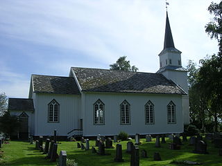
Henning, is a village in the municipality of Steinkjer in Trøndelag county, Norway. The village lies about 10 kilometres (6.2 mi) southeast of the town of Steinkjer, about 7 kilometres (4.3 mi) south of Ogndal, and about 5 kilometres (3.1 mi) north of the lake Leksdalsvatnet. The main church for this area is Henning Church, located on the south side of the village. The parish is called Henning.
Beitstadfjorden is the innermost arm of the Trondheimsfjord in Trøndelag county, Norway. It is located in Steinkjer Municipality, Inderøy Municipality, and a small part extends into Indre Fosen Municipality. The fjord has a length of 28 kilometres (17 mi) from southwest to northeast, and a width of about 6 to 8 kilometres.

Steinkjerelva is a 2.2-kilometer (1.4 mi) long river in the town of Steinkjer in Steinkjer Municipality in Trøndelag county, Norway. It forms at the confluence between the rivers Byaelva and Ogna at Guldbergaunet and flows through the town of Steinkjer before flowing into Beitstadfjorden, the inner part of the Trondheimsfjord. The river is crossed by four bridges, including one for the Nordland Line and the Sneppen Bridge which is part of the European route E6 highway. The river drains the entire Snåsavatnet watershed, which covers an area of 2,143 square kilometers (827 sq mi).

Steinkjer is the administrative centre of the municipality of Steinkjer in Trøndelag county, Norway. The town is located at the northeastern end of the inner-most part of the Trondheimsfjorden, at the mouth of the river Steinkjerelva. In the eastern part of the town, the river of Figgja also flows into the fjord. The town is split in two by Steinkjerelva, creating the two traditional neighborhoods of Nordsia and Sørsia. Both the European route E6 highway and the Nordlandsbanen railway line run through the town, the latter serving the city at Steinkjer Station. Steinkjer Church and Egge Church are both located in the town.

Ogna is a former municipality in Rogaland county, Norway. The 104-square-kilometre (40 sq mi) municipality existed from 1839 until its dissolution in 1964. The municipality encompassed roughly the southern third of the present-day municipality of Hå. The administrative centre of the municipality was the village of Ogna where the Ogna Church is located.
Kvam is a village in Steinkjer municipality in Trøndelag county, Norway. The village is located along the northern shore of the lake Snåsavatnet along the European route E6 highway, about 11 kilometres (6.8 mi) northeast of the village of Følling and about 20 kilometres (12 mi) northeast of the town of Steinkjer. The small village of Kvam lies directly on the lake shore and it has a school, store, senior living center, and Kvam Church. Farther north from the lake includes a wilderness area including the large lakes Gilten and Bangsjøan. The village was the administrative centre of the old municipality of Kvam which existed from 1909 until its dissolution in 1964.

Namdalseid is a village in Namsos Municipality in Trøndelag county, Norway. The village is located along the Norwegian County Road 17, about 30 kilometres (19 mi) north of the town of Steinkjer and about the same distance south of the town of Namsos. The Namdalseid Church sits just southwest of the village. There's a school in the village as well.
