
Vansjø is a lake in the municipalities of Moss, Råde, Rygge, Våler in Østfold county, Norway.
Tisleifjorden is a lake on the border of Innlandet and Buskerud counties in Norway. The lake lies in Nord-Aurdal municipality in Innlandet county, as well in Gol and Hemsedal municipalities in Buskerud county. Tisleifjorden is dammed for hydroelectric power. The height of the lake sits around 819 metres (2,687 ft) above sea level, but it can vary up to 11 metres (36 ft). The 13.54-square-kilometre (5.23 sq mi) lake has a circumference of about 32.5 kilometres (20.2 mi). It is located about 25 kilometres (16 mi) to the southwest of the town of Fagernes.
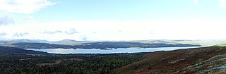
Rien is a lake in the municipality of Røros in Trøndelag county, Norway. The 14.87-square-kilometre (5.74 sq mi) lake is located near the headwaters of the river Glomma, only about 10 kilometres (6.2 mi) west of the border with Sweden. The water flows out through the river Glomma and heads a short distance south, into the large lake Aursunden. The village of Brekken lies about 6 kilometres (3.7 mi) south of the lake and the town of Røros lies about 40 kilometres (25 mi) to the southwest.

Aksdalsvatnet is a lake in the municipality of Tysvær in Rogaland county, Norway. The 3.46-square-kilometre (1.34 sq mi) lake lies southeast of the village of Førre and south of the village of Aksdal. The European route E134 highway runs along the northern shore of the lake and the European route E39 highway runs along the eastern shore of the lake.
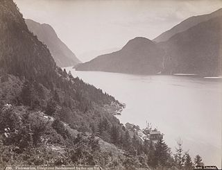
Bandak is a lake in the municipalities of Kviteseid and Tokke in Telemark county, Norway. The lake, which is part of the Telemark Canal route, belongs to the Skien watershed. The river Tokke flows into the lake, and the outlet is via the river Strauman, which flows to the lake Kviteseidvatn.

Ara or Aremarksjøen is a lake in the municipality of Aremark in Østfold county, Norway.

Lyseren is a lake in the municipalities of Enebakk in Akershus county and Indre Østfold in Østfold county, Norway.
Øgderen is a lake in the municipalities of Aurskog-Høland in Akershus county and Trøgstad in Østfold county, Norway.

Ørsjøen is a lake in the municipality of Halden in Østfold county, Norway.
Tinnhølen or Tinnhylen is a lake in Norway that lies in the municipality of Eidfjord in Vestland county and a very small part crosses into the municipality of Nore og Uvdal in Buskerud county. The lake lies just inside Hardangervidda National Park on the vast Hardangervidda plateau. The northern part of the lake is accessible by road.
Bjornesfjorden is a lake in the municipality of Nore og Uvdal in Buskerud county, Norway. It lies at 1,223 meters above sea level. It is drained by the Numedalslågen. Bjornesfjorden is situated in the Hardangervidda plateau and lies within the Hardangervidda National Park.
Stolsvatnet is a regulated lake in the municipalities of Ål and Hol in Buskerud, Norway. Stolsvatnet was formed in the late 1940s by the damming of the upper parts of three rivers, which created a continuous lake across the watersheds. The new lake covered a number of existing smaller lakes. It is a reservoir for Hol I kraftverk, a hydroelectric power plant located off FV 50 by Hovet in Hol. The power plant is owned and operated by E-Co Energi.

Vavatn is a lake in the municipality of Hemsedal in Buskerud county, Norway. It is a water source for Gjuva kraftverk, a hydro-electric power plant, which utilizes the waterfall from the lake into the Gjuva river as it enters the valley of Grøndalen. The power station was put into operation in 1957 but was rehabilitated in 1995. The owner-operator is E- CO Energi.
Ørteren is a lake in the municipality of Hol in Buskerud county, Norway.

Rødungen is a lake in Buskerud County, Norway. The lake is located on the border between the municipalities of Ål and Nore og Uvdal. Waterfall from the lake is a power source for Usta kraftverk, a hydro-electric plant. The power station exploits the fall of the Usta River from Rødungen as well as Ustevatn. The plant started production in 1965 and is owned and operated by E- CO Energi.
Tingvollfjorden is a small fishing lake in the municipality of Ål in Buskerud county, Norway. The lake is located in the valley of Hallingdal, northwest of Honefoss on the watershed of the Hallingdalselva.
Bjørkelangen is a lake in the municipality of Aurskog-Høland in Akershus county, Norway.

Klistervatnet is a lake that lies on the border between Norway and Russia. The 17.2-square-kilometre (6.6 sq mi) lake lies on the river Pasvikelva and it is about 10 kilometres (6.2 mi) long and 2 kilometres (1.2 mi) wide. The lake is located north of lake Bjørnevatnet.

Østernvann is a lake north of Fossum in the municipality of Bærum in Akershus county, Norway.

Rostojávri (Northern Sami), Råstojaure (Swedish), or Store Rostavatn (Norwegian) is a lake on the border between Norway and Sweden. The Norwegian side of the lake is located in Målselv Municipality in Troms county and the Swedish side of the lake is located in Kiruna Municipality in Norrbotten County. The Norwegian part of the lake lies inside Øvre Dividal National Park. The lake lies at an elevation of 680 metres (2,230 ft) and covers a total area of 34.24 square kilometres (13.22 sq mi); with 3.67 square kilometres (1.42 sq mi) located in Norway and the remaining 30.57 square kilometres (11.80 sq mi) are located in Sweden.
