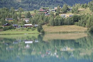
Skjolden is a village in the municipality of Luster in Vestland county, Norway. It is located at the end of the Lustrafjorden, a branch of the Sognefjorden. Skjolden is located at the innermost point of the Sognefjorden, Norway's longest fjord, and the length of the Sognefjorden is measured from Skjolden to the island of Ytre Sula where the fjord meets the ocean—over 200 km. The valleys of Mørkridsdal and Fortunsdal meet at Skjolden, just west of the Hurrungane mountains. Skjolden is home to about 200 people.
Sandvatnet or Kaldfjorden or Øyvatnet is a lake in Innlandet county, Norway. The 19.18-square-kilometre (7.41 sq mi) lake is rather unique because it has three parts and each part has a different name. Sandvatnet is the western part, Kaldfjorden is the central portion and Øyvatnet is the eastern part. The lake lies in Nord-Fron, Sør-Fron and Øystre Slidre municipalities.

Slidrefjord or Slidrefjorden is a lake that lies in Vestre Slidre Municipality in Innlandet county, Norway. The lake is not an actual fjord, just a lake that is part of the Begna river watershed.

Rauddalsvatnet is a lake in Skjåk Municipality in Innlandet county, Norway. The 7.4977-square-kilometre (2.8949 sq mi) lake lies just outside the Reinheimen National Park (which surrounds the lake on three sides. The lake sits at an elevation of 916 metres above sea level and it has a perimeter of 22.23 kilometres. The lake sits in a narrow valley with the mountain Skridulaupen to the north and Dyringshøi to the south. The lake lies in an isolated valley, about 25 kilometres west of the village of Bismo.
Aursjoen is a lake in Skjåk Municipality in Innlandet county, Norway. The 7.3783-square-kilometre (2.8488 sq mi) lake sits at an elevation of 1,098 metres (3,602 ft) above sea level. The lake lies about 5 kilometres (3.1 mi) north of the village of Bismo. The mountain Horrungen lies just east of the lake. Reinheimen National Park lies just north of the lake.

Oltedalsvatnet is a lake in the municipality of Gjesdal in Rogaland county, Norway. The 3.12-square-kilometre (1.20 sq mi) lake lies just south of the village of Oltedal. It is a reservoir along the river Oltedalsåna that is used to store water for the Oltedal Hydroelectric Power Station. The lake sits at an elevation of 101.5 to 112.5 metres and it holds about 28,800,000 cubic metres.
Innsvatnet is a lake in the municipality of Verdal in Trøndelag county, Norway. The lake lies in the eastern part of the municipality, just west of the border with Sweden. The lake is the headwaters for the river Inna, which later flows into the Verdalselva river. The 3.9-square-kilometre (1.5 sq mi) lake sits at an elevation of 415 metres (1,362 ft) above sea level.
Veresvatnet or Veressjøen is a lake in the municipality of Verdal in Trøndelag county, Norway. The lake lies in the eastern part of the municipality, just west of the border with Sweden and just south of Blåfjella–Skjækerfjella National Park. The 6.5-square-kilometre (2.5 sq mi) lake sits at an elevation of 360 metres (1,180 ft) above sea level, and it is considered to be one of the headwaters of the Verdalselva river since the lake's water flows out into the river Helgåa which later joins the Verdalselva. The village of Vera and the Vera Chapel lie on the northern shores of the lake.
Granvinsvatnet is a lake in the Granvin area of Voss Municipality in Vestland county, Norway. The 4.05-square-kilometre (1.56 sq mi) lake sits just north of the village of Eide.
Oppheimsvatnet is a lake in the municipality of Voss in Vestland county, Norway. The 3.55-square-kilometre (1.37 sq mi) lake lies in the northern part of the municipality, about 3 kilometres (1.9 mi) east of the village of Vinje. The European route E16 highway runs along the northern side of the lake, right past Oppheim Church which sits in the small village of Oppheim, after which the lake is named. The village of Vasstrondi lies on the southern shore.
Havdalsvatnet (Norwegian) or Haavhtere (Southern Sami) is a lake in the municipality of Lierne in Trøndelag county, Norway. The 8.12-square-kilometre (3.14 sq mi) lake lies in the northern part of the municipality, just south of the large lake Tunnsjøen. The village of Tunnsjø senter lies about 14 kilometres (8.7 mi) east of the lake and the lake Skorovatn lies about 8 kilometres (5.0 mi) to the west.
Nyhellervatnet is a lake on the border of the municipalities of Hol and Aurland, Norway. The 16.74-square-kilometre (6.46 sq mi) lake sits at an elevation of 1,438 metres (4,718 ft) above sea level. The lake is located about 30 kilometres (19 mi) southeast of the village of Aurlandsvangen, at the end of the Aurlandsdalen valley. In neighboring Viken county, the lake Djupsvatnet lies 10 kilometres (6.2 mi) to the east and Hallingskarvet National Park lies 10 kilometres (6.2 mi) to the south.
Samsjøen is a lake in Trøndelag county, Norway. The 10-square-kilometre (3.9 sq mi) lake sits on the border of the municipalities of Midtre Gauldal and Melhus. Most of the lake lies in Midtre Gauldal, about 12 kilometres (7.5 mi) north of the village of Singsås. The lake has a dam at the northwest end, which is used for hydroelectric power production. The water flows out of the lake and into the Lundesokna river which flows into the river Gaula.
Havvannet (Norwegian) or Vuolit Áhpelanjávri is a lake in Måsøy Municipality in Troms og Finnmark county, Norway. The 3.69 square kilometres (1.42 sq mi) lake lies isolated in the mountains on the Porsanger Peninsula about 9 kilometres (5.6 mi) northeast of the village of Kokelv in Kvalsund Municipality. The lake sits at an elevation of 293-metre (961 ft) above sea level. The village of Slåtten lies about 14 kilometres (8.7 mi) northwest of the lake.
Langsjøen is a lake in the municipalities of Tolga and Engerdal in Innlandet county, Norway. The 6.35-square-kilometre (2.45 sq mi) lake lies in the Sømådalen valley in the southeastern part of the municipality, just west of the large lake Femund. The village of Øversjødalen lies at the north end of the lake and the mountain Elgspiggen lies about 10 kilometres (6.2 mi) west of the lake.
Nedre Roasten is a lake in Femundsmarka National Park on the border of Innlandet and Trøndelag counties in Norway. The 2.29-square-kilometre (0.88 sq mi) lake sits on the border of the municipalities of Engerdal in Innlandet county and Røros in Trøndelag county. Nedre Roasten is about 50 kilometres (31 mi) southeast of the town of Røros and just under 9 kilometres (5.6 mi) from the border with Sweden. The lake lies about 5 kilometres (3.1 mi) east of the lake Femunden and about 8 kilometres (5.0 mi) west of the lake Rogen which sits along the Swedish border.

Vurrusjøen is a lake in Engerdal Municipality in Innlandet county, Norway. The 5-square-kilometre (1.9 sq mi) lake lies immediately west of the border with Sweden and the village of Drevsjø sits on the west end of the lake. The Swedish lake Fløtningsjøen lies just east of this lake.
Leksdalvatnet is a lake in Trøndelag county, Norway that lies in the municipalities of Steinkjer and Verdal. It is located south of the town of Steinkjer and northeast of the town of Verdalsøra, about 6 kilometres (3.7 mi) east of the Trondheimsfjord. The 21.73-square-kilometre (8.39 sq mi) lake sits at an elevation of 70 metres (230 ft) above sea level. It is drained by Figgja.
Kvesjøen is a lake in Lierne municipality in Trøndelag county, Norway. The lake lies just inside the Norwegian border with Sweden, on the west end of the lake Murusjøen. The 19.09-square-kilometre (7.37 sq mi) lake sits 320 metres (1,050 ft) above sea level. The lake contains at least six different fish species; Arctic char, burbot, two different species of trout, grayling and pike.
Kaldafjellet is a mountain on the border of Agder and Rogaland counties in southern Norway. The mountain lies on the border of the municipality of Suldal and the municipality of Bykle. The mountain has two peaks: the eastern one lies on the municipal-county border reaching 1,452 metres (4,764 ft), while the highest point on the mountain lies less than 1 kilometre (0.62 mi) to the west, reaching a peak of 1,480 metres (4,860 ft). The prominence of the mountain is 210 metres (690 ft) and the isolation is 4.2 kilometres (2.6 mi).


