
Gildeskål is a municipality in Nordland county, Norway. It is part of the Bodø Region and the traditional district of Salten. The administrative centre of the municipality is the village of Inndyr. Other villages include Forstranda, Lekanger, Mevik, Mårnes, Nygårdsjøen, Saura, Storvika, Sør-Arnøy, Sørfinnset, and Våg.

Beiarn is a municipality in Nordland county, Norway. It is part of the traditional district of Salten. Beiarn is also a part of the Bodø Region, a statistical metropolitan region. The administrative centre of the municipality is the village of Moldjord. Other villages in Beiarn are Høyforsmoen, Trones, and Tverrvika.

Glomfjord is a village in the municipality of Meløy in Nordland county, Norway. The industrial community is located along Norwegian County Road 17 at the head of the Glomfjorden, just north of the Arctic Circle. The 1.14-square-kilometre (280-acre) village has a population (2018) of 1,077 and a population density of 945 inhabitants per square kilometre (2,450/sq mi).

Rogen or Rovje is a lake on the border of Sweden and Norway. The lake is mostly located in Härjedalen Municipality in Jämtland county in Sweden with a small portion crossing the Norwegian border in the municipalities of Røros and Engerdal. The 35.12-square-kilometre (13.56 sq mi) lake is the source of Sweden's longest river, Klarälven.
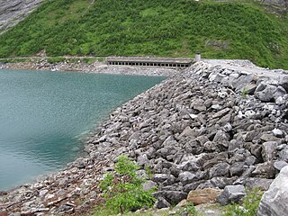
Arstaddalsdammen is a lake that lies in the municipality of Beiarn in Nordland county, Norway. It is located about 15 kilometres (9.3 mi) southwest of the village of Moldjord. The 2.54-square-kilometre (0.98 sq mi) lake lies in the southern end of the Arstaddal valley, and it has a dam on the northern end. The dam was built in the 1960s. The water from the lake is piped to the nearby lake Sokumvatnet in Gildeskål Municipality. The lake serves as a reservoir for the Sundsfjord Hydroelectric Power Station.

Fjerdvatnet or Kråkmovatnet (Norwegian) or Skilggajávri (Lule Sami) is a lake in the municipality of Hamarøy in Nordland county, Norway. The European route E06 highway runs along the eastern shore of the lake. The lake lies about 12 kilometres (7.5 mi) southeast of the village of Tømmerneset. The large lake Rekvatnet lies just to the east and the lake Sandnesvatnet lies just to the north of this lake.

Gresvatnet (Norwegian) or Gräsvattnet (Swedish) or Graesiejaevrie (Southern Sami) is a lake on the border between Norway and Sweden. Most of the lake lies in Hemnes Municipality in Nordland county (Norway) and then a small portion crosses the border into Storuman Municipality in Västerbotten County (Sweden). The lake lies about 25 kilometres (16 mi) east of the village of Korgen, and just a few kilometres northeast of the mountain Oksskolten and the Okstindbreen glacier. The lake is one of the upper reservoirs for the Bjerka Hydroelectric Power Station.
Langvatnet is a lake that lies in the municipality of Gildeskål in Nordland county, Norway. The lake is located about 15 kilometres (9.3 mi) southeast of the municipal centre of Inndyr. It sits directly southwest of the large lake Sokumvatnet. The lake is partially supplied by discharge from the Langvann Hydroelectric Power Station and serves as a reservoir for the Sundsfjord Hydroelectric Power Station.
Litlumvatnet (Norwegian), Lill-Uman (Swedish), or Jovsjaevrie (Southern Sami) is a lake on the border of Norway and Sweden. The Norwegian side lies in Rana Municipality in Nordland county and the Swedish side lies in Storuman Municipality in Västerbotten County. The lake lies about 40 kilometres (25 mi) southeast of the town of Mo i Rana. The lake is 5.24 square kilometres (2.02 sq mi) and about 1.8 square kilometres (0.69 sq mi) lies inside Norway and the rest lies in Sweden.
Lysvatnet is a lake that lies in the municipality of Meløy in Nordland county, Norway. The 4.53-square-kilometre (1.75 sq mi) is located near the border with Gildeskål Municipality, about 5.5 kilometres (3.4 mi) east of the municipal centre of Ørnes. The lake Markavatnet lies about 3 kilometres (1.9 mi) to the west of this lake.
Sandnesvatnet (Norwegian) or Sáttonjárgjávrre (Lule Sami) is a lake in the municipality of Hamarøy in Nordland county, Norway. The European route E06 highway runs along the eastern and northern shores of the lake. The lake lies about 5 kilometres (3.1 mi) southeast of the village of Tømmerneset. The lake Strindvatnet lies just to the northwest and the lake Fjerdvatnet lies to the south of the lake.
Sokumvatnet is a lake that lies in the municipality of Gildeskål in Nordland county, Norway. Sokumvatnet is located about 15 kilometres (9.3 mi) southeast of the village of Inndyr. It lies just south of the lake Litle Sokumvatnet and northeast of the lake Langvatnet. The lake serves as a reservoir for the Sundsfjord Hydroelectric Power Station.
Vuolep Sårjåsjávrre is a lake which lies on the border between Norway and Sweden. The western part lies in Fauske Municipality in Nordland county, Norway, and the eastern part lies in Jokkmokk Municipality in Norrbotten County, Sweden. The 7.17-square-kilometre (2.77 sq mi) lake lies just to the east of the large Blåmannsisen glacier and smaller neighboring lake Bajep Sårjåsjávrre.
Havdalsvatnet (Norwegian) or Haavhtere (Southern Sami) is a lake in the municipality of Lierne in Trøndelag county, Norway. The 8.12-square-kilometre (3.14 sq mi) lake lies in the northern part of the municipality, just south of the large lake Tunnsjøen. The village of Tunnsjø senter lies about 14 kilometres (8.7 mi) east of the lake and the lake Skorovatn lies about 8 kilometres (5.0 mi) to the west.

Havvannet (Norwegian) or Vuolit Áhpelanjávri is a lake in Måsøy Municipality in Finnmark county, Norway. The 3.69 square kilometres (1.42 sq mi) lake lies isolated in the mountains on the Porsanger Peninsula about 9 kilometres (5.6 mi) northeast of the village of Kokelv in Kvalsund Municipality. The lake sits at an elevation of 293-metre (961 ft) above sea level. The village of Slåtten lies about 14 kilometres (8.7 mi) northwest of the lake.

Innerdalstårnet or Dalatårnet is a 1,452-metre (4,764 ft) tall mountain on the south side of the Innerdalen valley in Sunndal Municipality in Møre og Romsdal county, Norway. It is located about 15 kilometres (9.3 mi) southeast of the village of Ålvundeid. The mountain is also known as the Matterhorn of Norway for its characteristic pyramidal shape.
Litlesotra, or sometimes Lille Sotra, is an island in Fjell municipality in Hordaland county, Norway. It is part of the Sotra island group which makes up the southern part of a larger archipelago of islands from Fedje south through Øygarden. The 16.7-square-kilometre (6.4 sq mi) island has about 10,000 residents. The main settlement on the island is Straume. Other settlements include Knarrevik, Foldnes, and Brattholmen. The island is connected to the mainland via the Sotra Bridge. It is also connected to the large island of Sotra, via a series of bridges over the island of Bildøy.

Gillsvannet or Gjelsvannet is a freshwater lake in the municipality of Kristiansand in Vest-Agder county, Norway. The 1.05-square-kilometre (260-acre) lake is located about 5 kilometres (3.1 mi) northeast of downtown Kristiansand, along to County Road 452. The lake lies about 300 metres (980 ft) west of the Topdalsfjorden, at an elevation of about 1 metre above sea level. There is a practice range for kayaking on the lake as well as many areas used for swimming during the summer season. The Gimlekollen district lies on the southern shore of the lake and the village of Justvik lies just north of the lake.

The Forså Hydroelectric Power Station is a hydroelectric power station in the municipality of Gildeskål in Nordland county, Norway. Part of the plant's catchment area also lies in the municipality of Beiarn.

The Sundsfjord Hydroelectric Power Station is a hydroelectric power station in the municipality of Gildeskål in Nordland county, Norway. Part of the plant's catchment area also lies in the municipality of Beiarn.


