
The Mariana Trench or Marianas Trench is located in the western Pacific Ocean approximately 200 kilometres (124 mi) east of the Mariana Islands, and has the deepest natural trench in the world. It is a crescent-shaped trough in the Earth's crust averaging about 2,550 km (1,580 mi) long and 69 km (43 mi) wide. The maximum known depth is 10,994 metres (36,070 ft) at the southern end of a small slot-shaped valley in its floor known as the Challenger Deep. However, some unrepeated measurements place the deepest portion at 11,034 metres (36,201 ft). For comparison: if Mount Everest were dropped into the trench at this point, its peak would still be over two kilometres (1.2 mi) under water.
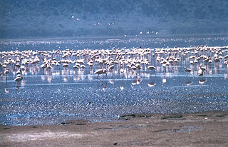
The Rift Valley lakes are a group of lakes in the East African Rift that runs north-south through the eastern side of the African continent, from Ethiopia in the north to Malawi in the south. These lakes include some of the oldest, largest, and deepest lakes in the world. Many are freshwater ecoregions of great biodiversity, while others are alkaline "soda lakes" supporting highly specialised organisms.

Femunden is Norway's third largest lake and the second largest natural lake in Norway. It is located in Hedmark and Trøndelag counties in Norway, just 13 kilometres (8.1 mi) west of the border with Sweden. The lake lies primarily in the municipality of Engerdal and also smaller parts are located in the municipalities of Os (Hedmark) and Røros (Trøndelag). Femundsmarka National Park borders the northeastern part of the lake.

Hornindalsvatnet is Norway's and Europe's deepest lake, officially measured to a depth of 514 metres (1,686 ft). Its surface is 53 metres (174 ft) above sea level, which means that its bottom is 461 metres (1,512 ft) below sea level. The village of Grodås lies at the eastern end of the lake in Hornindal Municipality and the village of Mogrenda is located on the western end of the lake in Eid Municipality. The European route E39 highway runs near the lake. The village of Heggjabygda and Heggjabygda Church lie on the northern shore of the lake.

Nordfjord is a traditional district of Norway.
The Vestfold Hills are rounded, rocky, coastal hills, 411 square kilometres (159 sq mi) in extent, on the north side of Sorsdal Glacier on the Ingrid Christensen Coast of Princess Elizabeth Land, Antarctica. The hills are subdivided by three west-trending peninsulas bounded by narrow fjords. Most of the hills range between 30 and 90 metres in height, with the highest summit reaching nearly 160 metres (520 ft).

Snåsavatnet is Norway's sixth-largest lake. The 120-square-kilometre (46 sq mi) lake is located in the municipalities of Steinkjer and Snåsa in Trøndelag county, Norway. The villages of Følling and Sunnan lie at the southwestern end of the lake and the village of Snåsa lies at the northeastern end of the lake. The European route E6 highway runs along the northern shore of the lake and the Nordlandsbanen railway line runs along the southern shore.

Altevatnet (Norwegian) or Álddesjávri (Northern Sami) is Norway’s 11th largest lake. The 79.71-square-kilometre (30.78 sq mi) lake lies in the Bardu Municipality in Troms county, Norway. The lake is the largest lake in the county. It is approximately 38 kilometres (24 mi) long and about 2.5 kilometres (1.6 mi) wide. The lake is regulated by a dam on the northwestern end of the lake. The surface lies 489 metres (1,604 ft) above sea level and reaches a maximum depth of 99 metres (325 ft) below the surface of the lake.
Raggejavreraige or Råggejávrrerájgge is a cave located in a mountain above the Hellemofjorden in the municipality of Tysfjord in Nordland county, Norway. The cave is located near the lake Råggejávrre, about 2 kilometres (1.2 mi) south of the village of Musken. Råggejávrrerájgge is a limestone cave that has been eroded by this underground river. At 580 metres (1,900 ft) deep, it is the deepest cave in Scandinavia and the only known deep cave north of the Arctic Circle.

Tunnsjøen is a lake in the municipalities of Røyrvik and Lierne in Trøndelag county, Norway. The 100.18-square-kilometre (38.68 sq mi) lake lies just south of the large lake Limingen, and just west of the border with Sweden. It is 358 metres (1,175 ft) above sea level and has a volume of 8.68 cubic kilometres (2.08 cu mi). The deepest part of the lake is 220 metres (720 ft) deep. It is the seventh largest lake in Norway.

Limingen is a lake in the municipalities of Røyrvik and Lierne in Trøndelag county, Norway. It is the eighth-largest lake in the country. The lake lies 418 metres (1,371 ft) above sea level and has an area of 93 square kilometres (36 sq mi). At the deepest point, it is 192 metres (630 ft) deep and averages about 87 metres (285 ft) deep. The lake has a volume of 8.34 cubic kilometres (2.00 cu mi) and is located just north of the large lake Tunnsjøen. The border with Sweden lies about 725 metres (0.5 mi) east of the lake.
Lundevatn, or Lundevatnet, is a lake on the borders between the municipalities of Lund and Flekkefjord in Norway. The village of Moi lies at the northern end of the lake and the smaller village of Åna-Sira lies just south of the southern end of the lake. The lake has a small dam at the southern end and it is used for the nearby Åna-Sira Power Station.
Vegår is a lake in the municipality of Vegårshei in Aust-Agder county, Norway. The 17.7-square-kilometre (6.8 sq mi) lake is located about 3 kilometres (1.9 mi) north of the municipal center of Myra and about 12 kilometres (7.5 mi) east of the village of Åmli in the neighboring municipality of Åmli.

Selura is a lake in the municipality of Flekkefjord in Vest-Agder county, Norway. The 5.7-square-kilometre (2.2 sq mi) lake is located at an elevation of 32 metres (105 ft) above sea level and it is about 130 metres (430 ft) at its deepest. The lake lies immediately northeast of the town of Flekkefjord

Aursunden or Aursund is a lake in the municipality of Røros in Trøndelag county, Norway. The village of Brekken lies along the eastern shore and the village of Glåmos lies along the western shore.

Jølstravatnet or Jølstravatn is a lake in the municipality of Jølster in Sogn og Fjordane county, Norway. The lake empties its water into the 20-kilometre (12 mi) long Jølstra river which then flows into the Førdefjorden. The impressive eastern arm of Jølstravatn is called Kjøsnesfjorden, although it is not a true fjord that is part of the sea. The villages of Skei, Helgheim, Ålhus, and Vassenden are located on the shores of the lake.

Suldalsvatnet is the sixth-deepest lake in Norway. The 376-metre (1,234 ft) deep lake lies in the municipality of Suldal in Rogaland county, Norway. The 28-square-kilometre (11 sq mi) lake is the headwaters of the river Suldalslågen and it sits at an elevation of 69 metres (226 ft) above sea level. The lake has a volume of 4.49 cubic kilometres (1.08 cu mi).

Overdeepening is a characteristic of basins and valleys eroded by glaciers. An overdeepened valley profile is often eroded to depths which are hundreds of metres below the deepest continuous line along a valley or watercourse. This phenomenon is observed under modern day glaciers, in salt-water fjords and fresh-water lakes remaining after glaciers melt, as well as in tunnel valleys which are partially or totally filled with sediment. When the channel produced by a glacier is filled with debris, the subsurface geomorphic structure is found to be erosionally cut into bedrock and subsequently filled by sediments. These overdeepened cuts into bedrock structures can reach a depth of several hundred metres below the valley floor.


