Related Research Articles

Geophysics is a subject of natural science concerned with the physical processes and physical properties of the Earth and its surrounding space environment, and the use of quantitative methods for their analysis. Geophysicists, who usually study geophysics, physics, or one of the Earth sciences at the graduate level, complete investigations across a wide range of scientific disciplines. The term geophysics classically refers to solid earth applications: Earth's shape; its gravitational, magnetic fields, and electromagnetic fields ; its internal structure and composition; its dynamics and their surface expression in plate tectonics, the generation of magmas, volcanism and rock formation. However, modern geophysics organizations and pure scientists use a broader definition that includes the water cycle including snow and ice; fluid dynamics of the oceans and the atmosphere; electricity and magnetism in the ionosphere and magnetosphere and solar-terrestrial physics; and analogous problems associated with the Moon and other planets.
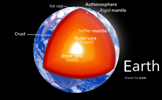
![<span class="mw-page-title-main">Earth's outer core</span> Fluid layer composed of mostly iron and nickel between Earths solid [[inner core]] and its mantle](https://upload.wikimedia.org/wikipedia/commons/thumb/e/ee/Earth-crust-cutaway-english.svg/320px-Earth-crust-cutaway-english.svg.png)
Earth's outer core is a fluid layer about 2,260 km (1,400 mi) thick, composed of mostly iron and nickel that lies above Earth's solid inner core and below its mantle. The outer core begins approximately 2,889 km (1,795 mi) beneath Earth's surface at the core-mantle boundary and ends 5,150 km (3,200 mi) beneath Earth's surface at the inner core boundary.

Centrifugation is a mechanical process which involves the use of the centrifugal force to separate particles from a solution according to their size, shape, density, medium viscosity and rotor speed. The denser components of the mixture migrate away from the axis of the centrifuge, while the less dense components of the mixture migrate towards the axis. Chemists and biologists may increase the effective gravitational force of the test tube so that the precipitate (pellet) will travel quickly and fully to the bottom of the tube. The remaining liquid that lies above the precipitate is called a supernatant or supernate.
Seismic tomography or seismotomography is a technique for imaging the subsurface of the Earth using seismic waves. The properties of seismic waves are modified by the material through which they travel. By comparing the differences in seismic waves recorded at different locations, it is possible to create a model of the subsurface structure. Most commonly, these seismic waves are generated by earthquakes or man-made sources such as explosions. Different types of waves, including P, S, Rayleigh, and Love waves can be used for tomographic images, though each comes with their own benefits and downsides and are used depending on the geologic setting, seismometer coverage, distance from nearby earthquakes, and required resolution. The model created by tomographic imaging is almost always a seismic velocity model, and features within this model may be interpreted as structural, thermal, or compositional variations. Geoscientists apply seismic tomography to a wide variety of settings in which the subsurface structure is of interest, ranging in scale from whole-Earth structure to the upper few meters below the surface.

In biochemistry and cell biology, differential centrifugation is a common procedure used to separate organelles and other sub-cellular particles based on their sedimentation rate. Although often applied in biological analysis, differential centrifugation is a general technique also suitable for crude purification of non-living suspended particles. In a typical case where differential centrifugation is used to analyze cell-biological phenomena, a tissue sample is first lysed to break the cell membranes and release the organelles and cytosol. The lysate is then subjected to repeated centrifugations, where particles that sediment sufficiently quickly at a given centrifugal force for a given time form a compact "pellet" at the bottom of the centrifugation tube.

Gravimetry is the measurement of the strength of a gravitational field. Gravimetry may be used when either the magnitude of a gravitational field or the properties of matter responsible for its creation are of interest. The study of gravity changes belongs to geodynamics.

The internal structure of Earth are the layers of the Earth, excluding its atmosphere and hydrosphere. The structure consists of an outer silicate solid crust, a highly viscous asthenosphere, and solid mantle, a liquid outer core whose flow generates the Earth's magnetic field, and a solid inner core.

The core–mantle boundary (CMB) of Earth lies between the planet's silicate mantle and its liquid iron–nickel outer core, at a depth of 2,891 km (1,796 mi) below Earth's surface. The boundary is observed via the discontinuity in seismic wave velocities at that depth due to the differences between the acoustic impedances of the solid mantle and the molten outer core. P-wave velocities are much slower in the outer core than in the deep mantle while S-waves do not exist at all in the liquid portion of the core. Recent evidence suggests a distinct boundary layer directly above the CMB possibly made of a novel phase of the basic perovskite mineralogy of the deep mantle named post-perovskite. Seismic tomography studies have shown significant irregularities within the boundary zone and appear to be dominated by the African and Pacific Large low-shear-velocity provinces (LLSVP).

Geothermal gradient is the rate of change in temperature with respect to increasing depth in Earth's interior. As a general rule, the crust temperature rises with depth due to the heat flow from the much hotter mantle; away from tectonic plate boundaries, temperature rises in about 25–30 °C/km (72–87 °F/mi) of depth near the surface in the continental crust. However, in some cases the temperature may drop with increasing depth, especially near the surface, a phenomenon known as inverse or negative geothermal gradient. The effects of weather, the Sun, and season only reach a depth of roughly 10–20 m (33–66 ft).
Earth's inner core is the innermost geologic layer of the planet Earth. It is primarily a solid ball with a radius of about 1,220 km (760 mi), which is about 20% of Earth's radius or 70% of the Moon's radius.

Seismic anisotropy is the directional dependence of the velocity of seismic waves in a medium (rock) within the Earth.
Geophysical survey is the systematic collection of geophysical data for spatial studies. Detection and analysis of the geophysical signals forms the core of Geophysical signal processing. The magnetic and gravitational fields emanating from the Earth's interior hold essential information concerning seismic activities and the internal structure. Hence, detection and analysis of the electric and Magnetic fields is very crucial. As the Electromagnetic and gravitational waves are multi-dimensional signals, all the 1-D transformation techniques can be extended for the analysis of these signals as well. Hence this article also discusses multi-dimensional signal processing techniques.

Geodynamics is a subfield of geophysics dealing with dynamics of the Earth. It applies physics, chemistry and mathematics to the understanding of how mantle convection leads to plate tectonics and geologic phenomena such as seafloor spreading, mountain building, volcanoes, earthquakes, faulting. It also attempts to probe the internal activity by measuring magnetic fields, gravity, and seismic waves, as well as the mineralogy of rocks and their isotopic composition. Methods of geodynamics are also applied to exploration of other planets.

The Nankai Trough is a submarine trough located south of the Nankaidō region of Japan's island of Honshu, extending approximately 900 km (559 mi) offshore. The underlying fault, the Nankai megathrust, is the source of the devastating Nankai megathrust earthquakes, while the trough itself is potentially a major source of hydrocarbon fuel, in the form of methane clathrate.
In seismology, a microseism is defined as a faint earth tremor caused by natural phenomena. Sometimes referred to as a "hum", it should not be confused with the anomalous acoustic phenomenon of the same name. The term is most commonly used to refer to the dominant background seismic and electromagnetic noise signals on Earth, which are caused by water waves in the oceans and lakes. Characteristics of microseism are discussed by Bhatt. Because the ocean wave oscillations are statistically homogenous over several hours, the microseism signal is a long-continuing oscillation of the ground. The most energetic seismic waves that make up the microseismic field are Rayleigh waves, but Love waves can make up a significant fraction of the wave field, and body waves are also easily detected with arrays. Because the conversion from the ocean waves to the seismic waves is very weak, the amplitude of ground motions associated to microseisms does not generally exceed 10 micrometers.
In geophysics, seismic inversion is the process of transforming seismic reflection data into a quantitative rock-property description of a reservoir. Seismic inversion may be pre- or post-stack, deterministic, random or geostatistical; it typically includes other reservoir measurements such as well logs and cores.
Geomathematics is the application of mathematical methods to solve problems in geosciences, including geology and geophysics, and particularly geodynamics and seismology.
The Adams–Williamson equation, named after Leason H. Adams and E. D. Williamson, is an equation used to determine density as a function of radius, more commonly used to determine the relation between the velocities of seismic waves and the density of the Earth's interior. Given the average density of rocks at the Earth's surface and profiles of the P-wave and S-wave speeds as function of depth, it can predict how density increases with depth. It assumes that the compression is adiabatic and that the Earth is spherically symmetric, homogeneous, and in hydrostatic equilibrium. It can also be applied to spherical shells with that property. It is an important part of models of the Earth's interior such as the Preliminary reference Earth model (PREM).
The lower mantle, historically also known as the mesosphere, represents approximately 56% of Earth's total volume, and is the region from 660 to 2900 km below Earth's surface; between the transition zone and the outer core. The preliminary reference Earth model (PREM) separates the lower mantle into three sections, the uppermost (660–770 km), mid-lower mantle (770–2700 km), and the D layer (2700–2900 km). Pressure and temperature in the lower mantle range from 24–127 GPa and 1900–2600 K. It has been proposed that the composition of the lower mantle is pyrolitic, containing three major phases of bridgmanite, ferropericlase, and calcium-silicate perovskite. The high pressure in the lower mantle has been shown to induce a spin transition of iron-bearing bridgmanite and ferropericlase, which may affect both mantle plume dynamics and lower mantle chemistry.

Seismic velocity structure is the distribution and variation of seismic wave speeds within Earth's and other planetary bodies' subsurface. It is reflective of subsurface properties such as material composition, density, porosity, and temperature. Geophysicists rely on the analysis and interpretation of the velocity structure to develop refined models of the subsurface geology, which are essential in resource exploration, earthquake seismology, and advancing our understanding of Earth's geological development.
References
- ↑ "Non-Destructive Testing Resource Center - Glossary". Archived from the original on 2013-04-12. Retrieved 2006-12-09.
- ↑ "Chicago Wilderness Journal, Volume 1 - Number 1 - November, 2003" (PDF). Archived from the original (PDF) on 2006-09-28. Retrieved 2006-12-09.
- ↑ "CFI-Shadowgraph/Schliren Photography for Aerodynamic Applications" (PDF). Archived from the original (PDF) on 2007-02-26. Retrieved 2006-12-09.
- ↑ "Effects of sill processes and tidal forcing on exchange in eastern Long Island Sound".
- ↑ "GE Healthcare Density Gradient Separation". Archived from the original on 2006-10-09. Retrieved 2006-12-09.
- ↑ Herndon, J.M. (1996). "Substructure of the inner core of the Earth". Proceedings of the National Academy of Sciences of the United States of America. 93 (2). PNAS: 646–648. Bibcode:1996PNAS...93..646H. doi: 10.1073/pnas.93.2.646 . PMC 40105 . PMID 11607625.
- ↑ Dziewonski, Adam; Anderson, Don. "Preliminary reference Earth model" (PDF). Physics of the Earth and Planetary Interiors. Elsevier Scientific Publishing Company. Retrieved 30 June 2020.
- ↑ Kennett, B. L. N. "On the density distribution within the Earth". Geophysics Journal Int. Oxford Academics. Retrieved 30 June 2020.
- ↑ "The Spatial Distribution of Population in 48 World Cities: Implications for Economies in Transition" (PDF). Archived from the original (PDF) on 2006-09-05. Retrieved 2006-12-09.