
The Norwegian Water Resources and Energy Directorate is a Norwegian government agency established in 1921. It is under the Ministry of Petroleum and Energy and regulates the country's water resources and energy supply. Its mandate includes contingency planning for floods, serving as a centre of expertise for hydrology, research and development, and increasing energy efficiency. It is a member of the Council of European Energy Regulators.

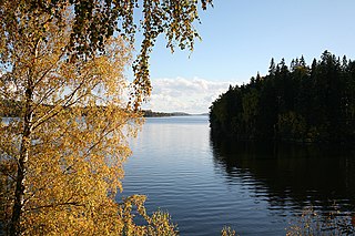
Rauddalsvatnet is a lake in Skjåk Municipality in Innlandet county, Norway. The 7.4977-square-kilometre (2.8949 sq mi) lake lies just outside the Reinheimen National Park (which surrounds the lake on three sides. The lake sits at an elevation of 916 metres above sea level and it has a perimeter of 22.23 kilometres. The lake sits in a narrow valley with the mountain Skridulaupen to the north and Dyringshøi to the south. The lake lies in an isolated valley, about 25 kilometres west of the village of Bismo.
Aursjoen is a lake in Skjåk Municipality in Innlandet county, Norway. The 7.3783-square-kilometre (2.8488 sq mi) lake sits at an elevation of 1,098 metres (3,602 ft) above sea level. The lake lies about 5 kilometres (3.1 mi) north of the village of Bismo. The mountain Horrungen lies just east of the lake. Reinheimen National Park lies just north of the lake.
Olefjorden is a lake in Vang Municipality in Innlandet county, Norway. The 6.2-square-kilometre (2.4 sq mi) lake lies about 15 kilometres (9.3 mi) to the northwest of the village of Beitostølen. The large lake Bygdin lies about 2 kilometres (1.2 mi) to the north of this lake.
Grønvatnet is a lake in Skjåk Municipality in Innlandet county, Norway. The 3-square-kilometre (1.2 sq mi) lake lies within the Tafjordfjella mountain range, about 10 kilometres (6.2 mi) north of the village of Grotli. The mountain lake lies in a low area surrounded by mountains, just west of Vulueggi, north of Krosshø, and south of Tordsnose.
Breiddalsvatnet is a lake in Skjåk Municipality in Innlandet county, Norway. The 6.9-square-kilometre (2.7 sq mi) lake lies just west of the village of Grotli. The Norwegian National Road 15 runs along the north side of the lake. The mountains Helleggi and Krosshø are located just north of the lake and the Breheimen National Park lies just south of the lake.
Rødenessjøen is a lake in the municipalities of Aurskog-Høland in Akershus county and Marker in Østfold county, Norway.
Rømsjøen is a lake in Rømskog in Aurskog-Høland, Akershus, Norway.
Store Erte is a lake in the municipality of Halden in Østfold county, Norway.

Øymarksjøen is a lake in the municipalities of Aremark and Marker in Østfold county, Norway.

Hurdalssjøen is a lake in the municipalities of Hurdal, Eidsvoll and Nannestad in Akershus county, Norway.
Sundvannet (Norwegian) or Sopmirjávri (Northern Sami) is a lake in Deatnu-Tana Municipality in Finnmark county, Norway. The lake has an area of 5.57-square-kilometre (2.15 sq mi) and lies 98 meters above sea level.

Visterflo is a lake in Østfold county, Norway. It forms a part of the Glomma watershed together with Ågårdselva and Mingevannet.
Gardsjøen is a lake in the municipality of Grue in Innlandet county, Norway. The 71-hectare (180-acre) lake is an oxbow lake that was formed by the river Glomma. Over time, this part of the river became separated from the river, forming a lake. The lake lies about 2 kilometres (1.2 mi) south of the village of Kirkenær.
Mangen is a lake in the municipalities of Eidskog in Innlandet county and Aurskog-Høland in Akershus county, Norway. The 4.129-square-kilometre (1.594 sq mi) lake lies about 20 kilometres (12 mi) northeast of the village of Aursmoen and about 20 kilometres (12 mi) west of the village of Skotterud.
Nugguren is a lake in the municipality of Kongsvinger in Innlandet county, Norway. The 4.15-square-kilometre (1.60 sq mi) lake lies about 2.3 kilometres (1.4 mi) east of the village of Brandval. The lake flows out into a very short channel before emptying into the river Glomma.
Råsen is a lake in the municipality of Nord-Odal in Innlandet county, Norway. The 2.3-square-kilometre (0.89 sq mi) lake lies just north of the village of Sand. The Norwegian County Road 181 runs along the southern end of the lake. The lake flows out into the river Sollauståa, which runs for about 2 kilometres (1.2 mi) to the south before emptying into the large lake Storsjø.

Vurrusjøen is a lake in Engerdal Municipality in Innlandet county, Norway. The 5-square-kilometre (1.9 sq mi) lake lies immediately west of the border with Sweden and the village of Drevsjø sits on the west end of the lake. The Swedish lake Fløtningsjøen lies just east of this lake.

Russvatnet is a lake in Vågå Municipality in Innlandet county, Norway. The 4.6-square-kilometre (1.8 sq mi) lake is located in the Jotunheimen mountain range and also within Jotunheimen National Park. It lies in a U-shaped valley between the mountains Surtningssue, Nautgardstinden, and Besshø.
Svanevatn is a lake on the border between Norway and Russia. The Norwegian branch is situated in Sør-Varanger municipality in Finnmark county.

