Related Research Articles
Mesodma is an extinct genus of mammal, a member of the extinct order Multituberculata within the suborder Cimolodonta, family Neoplagiaulacidae. It lived during the upper Cretaceous and Paleocene Periods of what is now North America. The earliest definitive record is from the late Santonian stage strata of the Straight Cliffs Formation. A single premolar tooth from the lower Cenomanian stage strata of the Cedar Mountain Formation has been tentatively assigned to this genus based on its similarity, but its describers noted that it is unlikely that Mesodma lived during that time.
The Danian is the oldest age or lowest stage of the Paleocene Epoch or Series, of the Paleogene Period or System, and of the Cenozoic Era or Erathem. The beginning of the Danian is at the Cretaceous–Paleogene extinction event 66 Ma. The age ended 61.6 Ma, being followed by the Selandian.
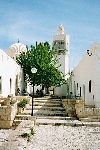
El Kef, also known as Le Kef, is a city in northwestern Tunisia. It serves as the capital of the Kef Governorate.

Berru is a commune in the Marne department in northeastern France.

Cernay-lès-Reims is a commune in the Marne department in north-eastern France.

The Paleocene, or Palaeocene, is a geological epoch that lasted from about 66 to 56 million years ago (mya). It is the first epoch of the Paleogene Period in the modern Cenozoic Era. The name is a combination of the Ancient Greek παλαιός palaiós meaning "old" and the Eocene Epoch, translating to "the old part of the Eocene".

El Fahs is a town and commune located in the Zaghouan Governorate, 60 kilometers south-west of Tunis, Tunisia. Its population in 2014 was 25,100.

The Paskapoo Formation is a stratigraphic unit of Middle to Late Paleocene age in the Western Canada Sedimentary Basin. The Paskapoo underlies much of southwestern Alberta, and takes the name from the Blindman River. It was first described from outcrops along that river, near its confluence with the Red Deer River north of the city of Red Deer, by Joseph Tyrrell in 1887. It is important for its freshwater aquifers, its coal resources, and its fossil record, as well as having been the source of sandstone for the construction of fire-resistant buildings in Calgary during the early 1900s.
The Santa Lucía Formation is a Maastrichtian to Paleocene (Danian) geologic formation in Bolivia. Fossil ornithopod tracks have been reported from the Cretaceous lower part of the formation. It is the type formation of the Tiupampan South American land mammal age.
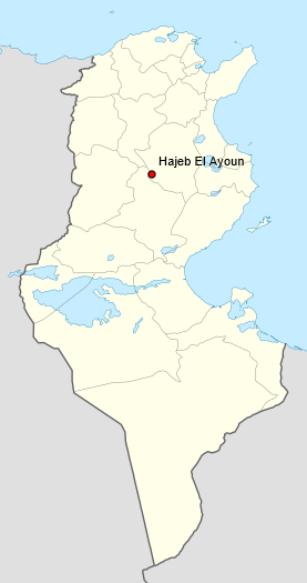
Hajeb El Ayoun is a town and commune in the Kairouan Governorate, Tunisia. As of 2004 it had a population of 9,648. It is also the capital of a district of 35,403 inhabitants.
Dahmani is a town in the Kef Governorate, located in northwestern Tunisia, with a population of around 31,000 inhabitants. Situated 27 km from El Kef and at an altitude of 625 meters, the town enjoys a cool climate, where snowfall can occur in winter. Dahmani is known for its pure water, making it a fertile region conducive to agriculture.

The Cerrejón Formation is a geologic formation in Colombia dating back to the Middle-Late Paleocene. It is found in the El Cerrejón sub-basin of the Cesar-Ranchería Basin of La Guajira and Cesar. The formation consists of bituminous coal fields that are an important economic resource. Coal from the Cerrejón Formation is mined extensively from the Cerrejón open-pit coal mine, one of the largest in the world. The formation also bears fossils that are the earliest record of Neotropical rainforests.
Compsemys is an extinct genus of prehistoric turtles from the Late Cretaceous and Paleocene of North America and possibly Europe. The type species C. victa, first described by Joseph Leidy from the Hell Creek Formation in Montana in 1856, and another probable species C. russelli, described in 2012, from Paleocene deposits in France. Its affinites have long been uncertain, but it has recently been considered to be the most basal member of Paracryptodira, despite the clade first appearing in the Late Jurassic, and is sometimes included in its own family, Compsemydidae. A revision in 2020 found Compsemydidae to be more expansive, also containing Riodevemys and Selenemys from the Late Jurassic of Europe, and Peltochelys from the Early Cretaceous of Europe.
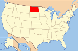
Paleontology in North Dakota refers to paleontological research occurring within or conducted by people from the U.S. state of North Dakota. During the early Paleozoic era most of North Dakota was covered by a sea home to brachiopods, corals, and fishes. The sea briefly left during the Silurian, but soon returned, until once more starting to withdraw during the Permian. By the Triassic some areas of the state were still under shallow seawater, but others were dry and hot. During the Jurassic subtropical forests covered the state. North Dakota was always at least partially under seawater during the Cretaceous. On land Sequoia grew. Later in the Cenozoic the local seas dried up and were replaced by subtropical swamps. Climate gradually cooled until the Ice Age, when glaciers entered the area and mammoths and mastodons roamed the local woodlands.
The Nanjemoy Formation is a geologic formation pertaining to both the Wilcox Group and the Pamunkey Group of the eastern United States, stretching across the states of Virginia, Maryland, and the District of Columbia. The formation crops out east of the Appalachians and dates back to the Paleogene period. Specifically to the Ypresian stage of the Early Eocene epoch, about 55 to 50 Ma or Wasatchian in the NALMA classification, defined by the contemporaneous Wasatch Formation of the Pacific US coast.
The Bogotá Formation (Spanish: Formación Bogotá, E1-2b, Tpb, Pgb) is a geological formation of the Eastern Hills and Bogotá savanna on the Altiplano Cundiboyacense, Eastern Ranges of the Colombian Andes. The predominantly shale and siltstone formation, with sandstone beds intercalated, dates to the Paleogene period; Upper Paleocene to Lower Eocene epochs, with an age range of 61.66 to 52.5 Ma, spanning the Paleocene–Eocene Thermal Maximum. The thickness of the Bogotá Formation ranges from 169 metres (554 ft) near Tunja to 1,415 metres (4,642 ft) near Bogotá. Fossils of the ungulate Etayoa bacatensis have been found in the Bogotá Formation, as well as numerous reptiles, unnamed as of 2017.

The Cesar-Ranchería Basin is a sedimentary basin in northeastern Colombia. It is located in the southern part of the department of La Guajira and northeastern portion of Cesar. The basin is bound by the Oca Fault in the northeast and the Bucaramanga-Santa Marta Fault in the west. The mountain ranges Sierra Nevada de Santa Marta and the Serranía del Perijá enclose the narrow triangular intermontane basin, that covers an area of 11,668 square kilometres (4,505 sq mi). The Cesar and Ranchería Rivers flow through the basin, bearing their names.
The geology of Tunisia is defined by the tectonics of North Africa, with large highlands like the Atlas Mountains as well as basins such as the Tunisian Trough. Geologists have identified rock units in the country as much as a quarter-billion years old, although most units date to the Mesozoic and Cenozoic, in the past 250 million years. Tunisia has a small but active mining industry and a significant oil and natural gas sector.
The geology of Israel includes igneous and metamorphic crystalline basement rocks from the Precambrian overlain by a lengthy sequence of sedimentary rocks extending up to the Pleistocene and overlain with alluvium, sand dunes and playa deposits.

Dortokidae is an extinct family of freshwater pan-pleurodiran turtles, known from the Cretaceous and Paleocene of Europe. Only four species have been named, but indeterminate fossils show that they were abundant across western and eastern-central Europe during the Cretaceous. The family is only known from postcranial remains.
References
- ↑ El Haria Archived 2023-06-01 at the Wayback Machine map.
- ↑ P. Saint-Marc, Biogeographic and bathymetric distribution of benthic foraminifera in Paleocene El Haria Formation of Tunisia, Journal of African Earth Sciences (and the Middle East) Volume 15, Issues 3–4, October–November 1992, Pages 473-487.
- ↑ Don Hallett, Daniel Clark-Lowes, Petroleum Geology of Libya (Elsevier, 1 Jun. 2016 ) p107.