
Flagler County is a county located in the northeastern portion of the U.S. state of Florida. As of the 2020 census, the population was 115,378. Its county seat is Bunnell, and the largest city is Palm Coast. Created in 1917 from portions of Saint Johns and Volusia Counties, it was named for Henry Flagler, who built the Florida East Coast Railway.

Martin County is a county located in the southeastern part of the state of Florida, in the United States. As of the 2020 census, the population was 158,431. Its county seat is Stuart. Martin County is in the Port St. Lucie, FL Metropolitan Statistical Area.
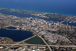
Palm Beach County is a county located in the southeastern part of Florida and lies directly north of Broward County and Miami-Dade County. The county had a population of 1,492,191 as of the 2020 census, making it the third-most populous county in the state of Florida and the 26th-most populous county in the United States. The largest city and county seat is West Palm Beach. Named after one of its oldest settlements, Palm Beach, the county was established in 1909, after being split from Dade County. The county's modern-day boundaries were established in 1963.

Lake Clarke Shores is a town in Palm Beach County, Florida, United States. Located in the east-central portion of the county, the town is situated just west of the south end of West Palm Beach, north and west of the north end of Lake Worth Beach, and east of Palm Springs. The 2010 census recorded a population of 3,376, while the U.S. Census Bureau estimated that Lake Clarke Shores had a population of 3,627 in 2019.

Lake Worth Beach, previously named Lake Worth, is a city in east-central Palm Beach County, Florida, United States, located about 64 miles (103 km) north of Miami. The city's name is derived from the body of water along its eastern border known as the Lake Worth Lagoon, which was named for General William J. Worth, who led United States Army forces during the last part of the Second Seminole War. Lake Worth Beach is situated south of West Palm Beach, southeast of Lake Clarke Shores, east of Palm Springs, and north of Lantana, while a small section of the city also partitions the town of Palm Beach. The 2010 census recorded a population of 34,910, which increased to 42,219 in the 2020 census. Lake Worth Beach is within the Miami metropolitan area, which was home to an estimated 6,138,333 people in 2020.

Palm Beach is an incorporated town in Palm Beach County, Florida. Located on a barrier island in east-central Palm Beach County, the town is separated from West Palm Beach and Lake Worth Beach by the Intracoastal Waterway to its west and a small section of the Intracoastal Waterway and South Palm Beach to its south. As of the 2020 census, Palm Beach had a year-round population of 9,245, an increase from 8,348 people in the 2010 census. An additional 25,000 people reside in Palm Beach annually between November and April.

West Palm Beach is a city in and the county seat of Palm Beach County, Florida, United States. It is located immediately to the west of the adjacent Palm Beach, which is situated on a barrier island across the Lake Worth Lagoon. The population was 117,415 at the 2020 census. West Palm Beach is a principal city of the Miami metropolitan area, which was home to 6,138,333 people in 2020. It is the oldest incorporated municipality in the South Florida area, incorporated as a city two years before Miami in November 1894. West Palm Beach is located approximately 68 miles (109 km) north of Downtown Miami.
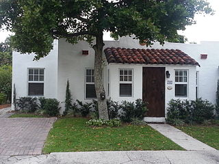
The Grandview Heights Historic District is a U.S. historic district located in West Palm Beach, Florida. The district is bounded by Park Place, Alabama Avenue, M Street, and Lake Avenue.

Lincolnville Historic District is a neighborhood in St. Augustine, Florida established by freedmen following the American Civil War and located on the southwest peninsula of the "nation's oldest city." It was designated as an historic district in 1991 and listed on the National Register of Historic Places. Originally recorded with 548 contributing buildings, the district is bounded by Cedar, Riberia, Cerro and Washington streets and DeSoto Place.
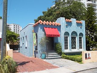
Burns Square Historic District is a historic district located in Sarasota, Florida, United States. The area runs from Ringling Boulevard to Mound Avenue along South Pineapple and South Orange Avenues. Burns Square is bound by Laurel Park Historic District to the east, Palm Avenue residential neighborhood to the west, and Hudson Bayou to the south.

The Breakers Palm Beach is a historic, Renaissance Revival style luxury hotel with 538 rooms. It is located at 1 South County Road in Palm Beach, Florida.

The Fred C. Aiken House is a good example of Addison Mizner's Mediterranean-inspired architecture from 1925. This historically designated residence is Located at the corner of Paloma Avenue and Hibiscus Street, in the Old Floresta Historic District in Boca Raton, Florida.
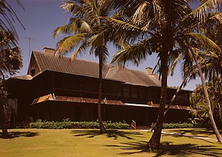
The Bingham-Blossom House, also known as Figulus, was a historic home and landscaped estate in Palm Beach, Palm Beach County, southeastern Florida. It was located at 1250 South Ocean Boulevard. It was damaged by fire and demolished in 1974.

The Lummus Park Historic District or simply Lummus Park, is on the National Register of Historic Places and a locally historic designated district in Miami, Florida. It is roughly bound by Northwest Fifth Street to the north, Flagler Street to the south, Northwest Third Avenue to the east, and the Miami River to the west. On October 25, 2006, it was added to the U.S. National Register of Historic Places. Lummus Park has some of the oldest structures in Miami, and over the decades, has been able to retain a large part of its early pioneer character.
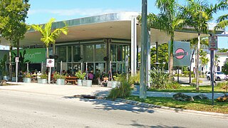
The Upper Eastside is a neighborhood in Miami, Florida. It is north of Edgewater, east of Little Haiti, south of the village of Miami Shores, and sits on Biscayne Bay. In geographical order from south to north and east to west, it contains the subdivisions of Magnolia Park, Bay Point, Morningside, Bayside, Belle Meade, Shorecrest, and Palm Grove. The MiMo District along Biscayne Boulevard in the area is host to many art galleries, shops and restaurants.

August Geiger was one of the most prominent American architects in South Florida from 1905 to the late 1940s. He experimented in Mission, Neo-Renaissance and Art Deco architecture, but is most noted for his works in the Mediterranean Revival style. A number of his works are listed on the U.S. National Register of Historic Places.
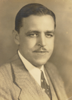
Gustav Adam Maass Jr. (1893–1964) was an American architect working primarily in the Mediterranean Revival style who designed public buildings and private homes in and around Palm Beach, Florida, from the 1920s until his death in 1964.
The history of West Palm Beach, Florida, began more than 5,000 years ago with the arrival of the first aboriginal natives. Native American tribes such as the Jaegas inhabited the area. Though control of Florida changed among Spain, England, the United States, and the Confederate States of America, the area remained largely undeveloped until the 20th century. By the 1870s and 1880s, non-Native American settlers had inhabited areas in the vicinity of West Palm Beach and referred to the settlement as "Lake Worth Country". However, the population remained very small until the arrival of Henry Flagler in the 1890s. Flagler constructed hotels and resorts in Palm Beach to create a travel destination for affluent tourists, who could travel there via his railroad beginning in 1894.
Fred A Henderich was a leading architect of the Florida land boom of the 1920s. He was a native of New York and graduated from Columbia University. Henderich came to Saint Augustine in 1905 to work for Henry Flagler's Florida East Coast Hotel Company and lived and worked in the city for over twenty years.

The Royal Poinciana Way Historic District is a historic commerce and residential district in Palm Beach, Florida. The district is bounded by the area from 207-283 Royal Poinciana Way, 95-118 North County Road, and 184-280 Sunset Avenue, with some exceptions. There are 36 buildings within the district, 26 of which are considered contributing properties. The Royal Poinciana Way Historic District became a listing in the National Register of Historic Places (NRHP) on September 17, 2015. A post office located at 95 North County Road has also been listed in the NRHP since 1983. Further, the town of Palm Beach considers the post office, Bradley House Hotel, and the Biltmore Apartments as town landmarks.


