El Mezerra

Last updated
El Mezerra
Commune and town
CountryFlag of Algeria.svg  Algeria
Province Tébessa Province
Time zone CET (UTC+1)

El Mezerra is a town and commune in Tébessa Province in north-eastern Algeria. [1]

Communes of Algeria administrative division of Algeria

The municipalities of Algeria form the second level of administrative subdivisions of Algeria. As of 2002, there were 1,541 municipalities in the country.

Algeria country in North Africa

Algeria, officially the People's Democratic Republic of Algeria, is a country in the Maghreb region of North Africa. The capital and most populous city is Algiers, located in the far north of the country on the Mediterranean coast. With an area of 2,381,741 square kilometres (919,595 sq mi), Algeria is the tenth-largest country in the world, the world's largest Arab country, and the largest in Africa. Algeria is bordered to the northeast by Tunisia, to the east by Libya, to the west by Morocco, to the southwest by the Western Saharan territory, Mauritania, and Mali, to the southeast by Niger, and to the north by the Mediterranean Sea. The country is a semi-presidential republic consisting of 48 provinces and 1,541 communes (counties). It has the highest human development index of all non-island African countries.

Related Research Articles

Kirundo Province Province in Burundi

Kirundo Province is one of the eighteen provinces of Burundi. Kirundo has three big lakes: Cohoha, Rweru, and Rwihinda. Lakes Cohoha and Rweru are located in commune Busone, and Lake Rwihinda is in commune Kirundo. Kirundo is the capital city of province Kirundo.

Kaniegue is a commune in the Cercle of San in the Ségou Region of Mali. The principal town lies at Dioundiou Konkankan. As of 1998 the commune had a population of 5,559.

MTarfa Commune and town in MSila Province, Algeria

M'Tarfa is a town and commune in M'Sila Province, Algeria. The commune is approximately 223 square kilometers in area. According to the 1998 census it has a population of 7,621. The 2008 census showed that the population had increased to 8,704, an increase of +0.59% per year. The commune has a desert climate and receives very little rainfall.

Zorg, Algeria is a town and commune in Oum El Bouaghi Province, Algeria. According to the 1998 census it has a population of 1,736.

Aïn Sidi Chérif is a town and commune in Mostaganem Province, Algeria. It is located in Mesra District. According to the 1998 census it has a population of 7,819.

Oued Keberit Commune and town in Souk Ahras Province, Algeria

Oued Keberit is a town and commune in Souk Ahras Province in north-eastern Algeria.

Safel El Ouiden Commune and town in Souk Ahras Province, Algeria

Safel El Ouiden is a town and commune in Souk Ahras Province in north-eastern Algeria.

Terraguelt Commune and town in Souk Ahras Province, Algeria

Terraguelt is a town and commune in Souk Ahras Province in north-eastern Algeria.

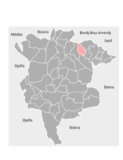
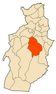
Aïn Lahdjar is a town and commune in Sétif Province in north-eastern Algeria.

Bir Haddada is a town and commune in Sétif Province in north-eastern Algeria.

Bir El Mokadem Commune and town in Tébessa Province, Algeria

Bir El Mokadem is a town and commune in Tébessa Province in north-eastern Algeria.

Cheria is a town and commune in Tébessa Province in north-eastern Algeria.

El Aouinet Commune and town in Tébessa Province, Algeria

El Aouinet is a town and commune in Tébessa Province in north-eastern Algeria.

El Ogla el Malha Commune and town in Tébessa Province, Algeria

El Ogla el Malha is a town and commune in Tébessa Province in north-eastern Algeria.

El Ogla, Tébessa Commune and town in Tébessa Province, Algeria

El Ogla is a town and commune in Tébessa Province in north-eastern Algeria.

Guorriguer is a town and commune in Tébessa Province in north-eastern Algeria.

Hammamet, Tébessa Commune and town in Tébessa Province, Algeria

Hammamet is a town and commune in Tébessa Province in north-eastern Algeria.

Tlidjene Commune and town in Tébessa Province, Algeria

Tlidjene is a town and commune in Tébessa Province in north-eastern Algeria.

Takhemaret Commune and town in Tiaret Province, Algeria

Takhemaret is a town and commune in Tiaret Province in north-western Algeria, about 65 km. southwest of the city of Tiaret. The 2008 census population was 34,124 in the commune, with 20,827 in the city.

The canton of Argentat is an administrative division situated in the Corrèze département and in the Nouvelle Aquitaine region of France. Since the French canton reorganisation which came into effect in March 2015, the communes of the canton of Argentat are:

References

  1. "Communes of Algeria". Statoids. Retrieved December 12, 2010.

Coordinates: 35°05′39″N7°34′49″E / 35.09417°N 7.58028°E / 35.09417; 7.58028

Geographic coordinate system Coordinate system

A geographic coordinate system is a coordinate system that enables every location on Earth to be specified by a set of numbers, letters or symbols. The coordinates are often chosen such that one of the numbers represents a vertical position and two or three of the numbers represent a horizontal position; alternatively, a geographic position may be expressed in a combined three-dimensional Cartesian vector. A common choice of coordinates is latitude, longitude and elevation. To specify a location on a plane requires a map projection.