Tobías Bolaños International Airport is one of four international airports in Costa Rica, and the secondary airport serving the city of San José, after Juan Santamaría International Airport. It is located in downtown San José, in Pavas District, San José Canton.
San José Airport serves the city of Puerto San José, the recreative town of Monterrico, the port of Puerto Quetzal and the eastern Guatemalan Pacific coast. It is operated and administrated by DGAC - Dirección General de Aeronáutica Civil de Guatemala. San José Airport is in the western part of the city of Puerto San José, near the Pacific coast.

Puerto Barrios Airport, formerly Izabal Air Base, serves the city of Puerto Barrios, the port of Santo Tomás de Castilla and the Guatemalan Caribbean. It is operated and administrated by Dirección General de Aeronáutica Civil (DGAC).

San Isidro de El General Airport is an airport serving the city of San Isidro de El General and Pérez Zeledón county, Costa Rica. The airport is 3 kilometres (2 mi) south of downtown San Isidro.

San Tomé Airport or El Tigre Airport is an airport at the town of San Tomé, in the Venezuelan state of Anzoátegui. Also known as Don Edmundo Barrios Airport, it serves the cities of El Tigre and San José de Guanipa, located 9 kilometres (5.6 mi) southwest of San Tomé.

Uaxactun Airport is an airstrip in the village of Uaxactun, Guatemala.

Matthew Spain Airport, formerly called Central Farm Airstrip, is a public use airport serving San Ignacio, a town in the Cayo District of Belize. The airport is 5 kilometres (3 mi) northeast of Santa Elena.
El Amarillo Airport Spanish: Aeropuerto El Amarillo, is an airstrip 21 kilometres (13 mi) east of Chaitén, a town in the Los Lagos Region of Chile. The Carretera Austral runs through the hamlet of El Amarillo, and passes the south end of the runway.

El Real de Santa María Airport is an airstrip serving the small town of El Real de Santa María, in the Darién Province of Panama. El Real is 6.5 kilometres (4.0 mi) southwest of Yaviza, the southern end of the North American section of the Pan American Highway. There are no paved roads between the two towns.
Carmelita Airport is an airstrip serving Carmelita, a small community in the Maya Biosphere Reserve of Guatemala. A section of the runway also serves as a street in the village.
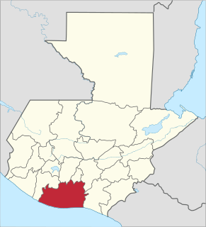
Bananera Airport is an airport serving the city of Morales in Izabal Department, Guatemala.

Ceiba Doblada Airport is an airstrip serving the village of Ceiba Doblada in Usulután Department, El Salvador. The unmarked grass runway is 8 kilometres (5.0 mi) east of the village.
Corral De Mulas Airport is an airport serving the village of Corral De Mulas in Usulután Department, El Salvador. The unmarked grass runway is west of and adjacent to the village.
Punta San Juan Airport is an airport serving the village of Corral De Mulas in Usulután Department, El Salvador. The unmarked grass runway is 7 kilometres (4.3 mi) east of the village on Punta San Juan, the western shore of the entrance to Bahia de Jiquilisco. Corral de Mulas is also served by Corral de Mulas Airport.
Los Comandos Airport is an airstrip serving the town of San Francisco Gotera in Morazán Department, El Salvador.
Espiritu Santo Airport is an airstrip serving the village of Espiritu Santo in Usulután Department, El Salvador. The runway is on a point in the Bahia de Jiquilisco.
La Cabaña Airport is an airstrip serving the town of La Cabaña in San Salvador Department, El Salvador.
La Chepona Airport is an airstrip serving the village of La Chepona in Usulután Department, El Salvador. The airstrip and village are on an estuarian island just east of the Jiquilisco Bay.
Las Cachas Airport is an airstrip serving the hamlet of Cangrejera in La Libertad Department, El Salvador.
San Ignacio Town Airstrip is a public use airport serving San Ignacio, a town in the Cayo District of Belize. The airport is 6 kilometres (4 mi) southwest of San Ignacio and 5 kilometres (3.1 mi) east of the border with Guatemala.