The Rio Grande is one of the principal rivers in the southwest United States and northern Mexico. The Rio Grande begins in south-central Colorado in the United States and flows to the Gulf of Mexico. After passing through the length of New Mexico along the way, it forms part of the Mexico–United States border. According to the International Boundary and Water Commission, its total length was 1,896 miles (3,051 km) in the late 1980s, though course shifts occasionally result in length changes. Depending on how it is measured, the Rio Grande is either the fourth- or fifth-longest river system in North America.
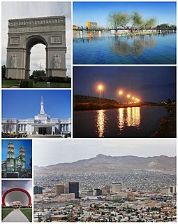
Ciudad Juárez is the most populous city in the Mexican state of Chihuahua. The city is commonly referred to as simply Juárez, and was known as El Paso del Norte until 1888. Juárez is the seat of the Juárez Municipality with an estimated population of 1.5 million people. It lies on the Rio Grande river, south of El Paso, Texas, United States. Together with the surrounding areas, the cities form El Paso–Juárez, the second largest binational metropolitan area on the Mexico–U.S. border, with a combined population of over 2.7 million people.

A border checkpoint is a place, generally between two countries, where travelers or goods are inspected. Authorization often is required to enter a country through its borders. Access-controlled borders often have a limited number of checkpoints where they can be crossed without legal sanctions. Arrangements or treaties may be formed to allow or mandate less restrained crossings. Land border checkpoints can be contrasted with the customs and immigration facilities at seaports, international airports, and other ports of entry.
Loop 375 is a beltway that partially encircles the city of El Paso, Texas. The beltway is mostly a freeway, except for its northern section, which includes at-grade intersections. The highway passes through various areas of El Paso, funneling traffic within and around the city. The road is known locally under different names, as Woodrow Bean Transmountain Drive in the northern section, Purple Heart Memorial Freeway in the northeastern section, Joe Battle Boulevard in the eastern section, the César Chávez Border Highway in the southern section, and the Border West Expressway on the southwest section.

The Camino Real de Tierra Adentro was an historic 2,560-kilometre-long (1,590 mi) trade route between Mexico City and San Juan Pueblo, New Mexico, USA, from 1598 to 1882. It was the northernmost of the four major "royal roads" that linked Mexico City to its major tributaries during and after the Spanish colonial era.
The Progreso–Nuevo Progreso International Bridge on the U.S.–Mexico border, has been in operation at this location since 1952. It connects the cities of Progreso, Texas, and Nuevo Progreso, Tamaulipas.

The Secure Electronic Network for Travelers Rapid Inspection (SENTRI) provides expedited U.S. Customs and Border Protection (CBP) processing, at the U.S.-Mexico border, of pre-approved travelers considered low-risk. Voluntarily applicants must undergo a thorough background check against criminal, customs, immigration, law enforcement, and terrorist databases; a 10-fingerprint law enforcement check; and a personal interview with a CBP Officer. The total enrollment fee is $122.25, and SENTRI status is valid for 5 years.
U.S. Highway 85 or US 85 is a route in the system of United States Numbered Highways maintained by the Texas Department of Transportation (TxDOT). The Texas portion of US 85 is located entirely within El Paso County beginning at the U.S.-Mexico border between the city of El Paso and Ciudad Juárez, Chihuahua. The approximately 20-mile (32 km) route briefly overlays US 62 in downtown El Paso, then traverses north along the city's west side before merging with the combined route of Interstate 10 and US 180. The route then follows I-10 and US 180 through the towns of Vinton and Anthony before crossing the New Mexico state line into the town of Anthony, New Mexico, in Doña Ana County.

The Bridge of the Americas (BOTA) is a group of international bridges which cross the Rio Grande and Texas State Highway Loop 375, connecting the Mexico–United States border cities of Ciudad Juárez, Chihuahua and El Paso, Texas, via the MX 45 from the south and the I-110 from the north, crossing the El Paso BOTA Port of Entry. The bridge is colloquially known as "Puente Libre" in Ciudad Juárez, officially as "Puente Internacional Córdova-Las Américas" or "Puente Internacional Córdova de las Américas", and also known as "Puente Río Bravo", "Cordova Bridge" and "Free Bridge".

The Good Neighbor International Bridge, commonly known as the Stanton Street Bridge, is an international bridge connecting the United States-Mexico border cities of El Paso, Texas, and Ciudad Juárez, Chihuahua across the Rio Grande. The bridge is also known as "Friendship Bridge", "Puente Río Bravo" and "Puente Ciudad Juárez-Stanton El Paso". The Good Neighbor International Bridge is a five lane bridge with 3 lanes for south bound traffic and one for Secure Electronic Network for Travelers Rapid Inspection northbound traffic. The bridge was completed in 1967 and is 880 feet (270 m) long. The U.S. side of the bridge is owned and operated by the City of El Paso.

The Paso del Norte International Bridge is an international bridge which crosses the Rio Grande connecting the United States-Mexico border cities of El Paso, Texas, and Ciudad Juárez, Chihuahua. The bridge is also known as "Paso del Norte Bridge", "Santa Fe Street Bridge", "Puente Benito Juárez", "Puente Paso del Norte" and "Puente Juárez-Santa Fe". The Paso del Norte International Bridge is a four-lane bridge for northbound non-commercial traffic only. The bridge was constructed in 1967. The American side of the bridge is owned and operated by the City of El Paso.
The Ysleta–Zaragoza International Bridge is an international crossing over the Rio Grande River, connecting the United States-Mexico border cities of El Paso, Texas, and Ciudad Juárez, Chihuahua. The bridge is also known as "Zaragoza Bridge", "Puente Zaragoza" and "Puente Ysleta-Zaragoza".

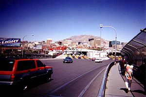
El Paso–Juárez, also known as Juárez–El Paso, the Borderplex or Paso del Norte, is a transborder agglomeration, on the border between Mexico and the United States. The region is centered on two large cities: Ciudad Juárez, Chihuahua, Mexico and El Paso, Texas, U.S. Additionally, nearby Las Cruces, New Mexico, U.S. is sometimes included as part of the region, referred to as El Paso–Juárez–Las Cruces or El Paso–Juárez–Southern New Mexico. With over 2.7 million people, this binational region is the 2nd largest conurbation on the United States–Mexico border. The El Paso–Juárez region is the largest bilingual, binational work force in the Western Hemisphere.

The San Ysidro Port of Entry is the largest land border crossing between San Diego and Tijuana, and the fourth-busiest land border crossing in the world with 70,000 northbound vehicles and 20,000 northbound pedestrians crossing each day, in addition to southbound traffic. It connects Mexican Federal Highway 1 on the Mexican side with Interstate 5 on the American side. The San Ysidro Port of Entry is one of three ports of entry in the San Diego–Tijuana metropolitan region.

The Santa Teresa, New Mexico Port of Entry was built in 1992 to relieve pressure from the busy El Paso bridge crossings a short distance to the east, and started operating in january 12th, 1993. General Services Administration is currently increasing the capacity of the port of entry, taking advantage of the available land. The crossing is open every day from 6:00 AM to 12:00 Midnight. The station has three maximum commercial vehicle lanes, and four maximum passenger lanes. The port of entry is located forty-two miles south of Las Cruces, New Mexico, and around twenty minutes from downtown El Paso, Texas.

The El Paso BOTA Port of Entry, located at the Bridge Of The Americas (BOTA), connecting Mexican Federal Highway 45 to the south and Interstate 110 to the north, is El Paso's highest volume border crossing, carrying more than half the vehicles entering El Paso, Texas from Mexico. This is due in large part to the fact that BOTA is the only bridge in between Mexico and Texas that does not charge a toll. It is a "Class A" service port with a full range of cargo processing functions, and it is open for passenger vehicle traffic 24/7. It is open for commercial truck inspections 6:00 AM–6:00 PM Weekdays, 6:00 AM–2:00 PM Saturdays.

The El Paso Stanton Street Port of Entry, located at the Good Neighbor International Bridge is limited to processing passenger vehicles that are enrolled in the SENTRI program. It is open from 6:00 AM - midnight weekdays, and 8:00 AM - midnight Saturdays and Sundays.
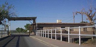
The Fabens Port of Entry was a port of entry at the Mexico–United States border, in the town of Fabens, Texas. It closed on November 17, 2014, and traffic was diverted to the nearby Tornillo Port of Entry. This facility was located at the Fabens–Caseta International Bridge, after that two-lane bridge was built by the International Boundary and Water Commission in 1938.

The Laredo Convent Avenue Port of Entry is located at the Gateway to the Americas International Bridge. Since 1889, a bridge connected Laredo, Texas with Nuevo Laredo, Tamaulipas at this location. For many years, this was the only crossing for vehicular and pedestrian traffic between the two cities.
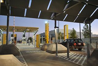
The Marcelino Serna Port of Entry is a new border crossing that has replaced the Fabens Port of Entry on the U.S.-Mexico border. It opened on November 17, 2014. The new crossing is built around the Tornillo-Guadalupe Bridge about 1800 feet west of the previous two-lane Fabens–Caseta International Bridge and can accommodate vehicular, pedestrian and commercial traffic. The U.S. Customs and Border Protection (CBP) facility at the crossing served as the site for the Tornillo tent city, which housed as many as 2,800 detained migrant youths from June 2018 to January 2019. As of July 2019, a 2,500-bed holding facility for adult migrants is under construction at the site.