El Pedregal Airstrip

Last updated
El Pedregal Airstrip
Summary
Airport type Private
Serves West San Quintin Bay, San Quintin, Pedrigal private homeowners community
Location San Quintín, Baja California
Elevation  AMSL 3 m / 10 ft
Coordinates 30°27′36″N115°57′46″W / 30.46000°N 115.96278°W / 30.46000; -115.96278 Coordinates: 30°27′36″N115°57′46″W / 30.46000°N 115.96278°W / 30.46000; -115.96278
Runways
Direction Length Surface
m ft
27/09 442 1,800' uphill slightly from bay to end to west Soil
There is a long runup and ground roll slab at RWY 27 of concrete some 100 ft long to keep rocks from nicking prop and stabilator until airspeed sufficient. TO West ALWAYS unless wind is reversed. Predominant onshore flow of 10-20Kts out of the West.

El Pedregal Airstrip is a private dirt airstrip located South West of San Quintín, Municipality of Ensenada, Baja California, Mexico, just on the headland of the San Quintín Bay. The airstrip is used solely for general aviation purposes.

San Quintín, Baja California Place in Baja California, Mexico

San Quintín is a coastal town on the west coast of the Mexican state of Baja California, in the Municipality of Ensenada, some 190 km (118 mi.) south of the city of Ensenada on Mexican Federal Highway 1. The town is also in the middle of an important agricultural area, especially for growing strawberries and tomatoes. The largest nearby locality is Lázaro Cardenas, home to 16,294 people as of the 2010 census. The whole area houses roughly 25,000 people, up from 20,000 in 2000. This is the largest population cluster south of Ensenada within the state.

Baja California Federal entity in Mexico

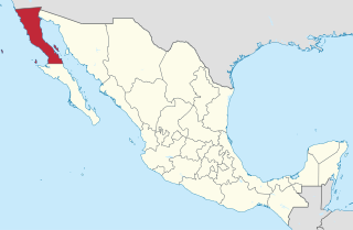
Baja California, officially the Free and Sovereign State of Baja California, is a state in Mexico. It is the northernmost and westernmost of the 32 Federal Entities of Mexico. Before becoming a state in 1952, the area was known as the North Territory of Baja California. It has an area of 70,113 km2 (27,071 sq mi), or 3.57% of the land mass of Mexico and comprises the northern half of the Baja California Peninsula, north of the 28th parallel, plus oceanic Guadalupe Island. The mainland portion of the state is bordered on the west by the Pacific Ocean, on the east by Sonora, the U.S. state of Arizona, and the Gulf of California, and on the south by Baja California Sur. Its northern limit is the U.S. state of California.

Mexico country in the southern portion of North America

Mexico, officially the United Mexican States, is a country in the southern portion of North America. It is bordered to the north by the United States; to the south and west by the Pacific Ocean; to the southeast by Guatemala, Belize, and the Caribbean Sea; and to the east by the Gulf of Mexico. Covering almost 2,000,000 square kilometres (770,000 sq mi), the nation is the fifth largest country in the Americas by total area and the 13th largest independent state in the world. With an estimated population of over 120 million people, the country is the eleventh most populous state and the most populous Spanish-speaking state in the world, while being the second most populous nation in Latin America after Brazil. Mexico is a federation comprising 31 states and Mexico City, a special federal entity that is also the capital city and its most populous city. Other metropolises in the state include Guadalajara, Monterrey, Puebla, Toluca, Tijuana and León.

Related Research Articles

San Quintín or San Quintin may refer to any of the following:

Ensenada Municipality Municipality in Baja California, Mexico

The municipality of Ensenada, with a land area of 52,482.40 km2 (20,263.57 sq mi), takes up the majority of the state of Baja California. It is the largest municipality in Mexico and in the Americas by area. It contains all of Baja California apart from a strip at the north and, at the northeast extremity of the state, the municipality of Mexicali. It is bordered by the Pacific Ocean on the west, the Gulf of California on the east, and by all of the other municipalities in Baja California on the North. Its municipal seat is Ensenada, which lies near the northwest corner of the municipality, although almost all of the municipality's territory lies far to its southeast. Its current municipal president is Enrique Pelayo Torres. A major port is planned to be built in Punta Colonet, a largely uninhabited area 80 km (50 mi) south of the city of Ensenada. Located offshore, Guadalupe Island is part of the municipality, making Ensenada the westernmost municipality of Latin America.

Mexican Federal Highway 1 highway in Mexico

Federal Highway 1 is a free (libre) part of the federal highway corridors of Mexico, and the highway follows the length of the Baja California Peninsula from Tijuana, Baja California, in the north to Cabo San Lucas, Baja California Sur, in the south. The road connects with Via Rapida, which merges into the American Interstate 5 (I-5) at the international border south of San Ysidro, California.

El Rosario, Baja California Place in Baja California, Mexico

El Rosario is a small town on the west coast of the state of Baja California on Highway 1, 61 km south of San Quintín and 119 km north of Cataviña. The census of 2010 reported a population of 1,704 inhabitants. It is part of the Municipio of Ensenada.

Palo Verde Airport

Palo Verde Airport is a paved airstrip located in San Bruno, a town 30 km south of Santa Rosalía, Baja California Sur, Mexico. The airstrip is also known as "Chivato Bay" and the CIB code is used as its identifier. It handles aviation for the city of Santa Rosalía.

Campo de Lorenzo Airpark is a privately owned public-use dirt airstrip located 6 miles (9 km) south of San Quintín, Municipality of Ensenada, Baja California, Mexico, just on the shore of the Pacific Ocean. This airport is used solely for general aviation purposes.

The San Quintin kangaroo rat is a species of rodent in the family Heteromyidae. It is endemic to Mexico, where it is known only from western Baja California. Its natural habitat is arid lowlands with sparse vegetation.

Rancho Magaña Airstrip is a privately owned public-use dirt airstrip located North of San Quintín, Municipality of Ensenada, Baja California, Mexico, just on the East side of the Federal Highway 1. The airstrip is used solely for general aviation purposes. The MAG code is used as identifier.

Cielito Lindo Airstrip is a public-use dirt airstrip located South of San Quintín, Municipality of Ensenada, Baja California, Mexico, just on the Pacific Ocean coast, near the "La Pinta" Hotel. The airstrip is used solely for general aviation purposes. The CND code is used as identifier.

Los Pinos Airstrip is a paved airstrip located South of San Quintín, Municipality of Ensenada, Baja California, Mexico, just on the East side of the Federal Highway 1, to the East of "Hotel Santa Maria" and Cielito Lindo Airstrip. The Flying Samaritans' Mother Lode and Tucson chapters operate a monthly fly-in clinic here and in El Rosario to the south. The airstrip is used solely for general aviation purposes.

San Quintín Military Airstrip is the military airstrip located at Military Camp Number 2-D, located in San Quintín, Municipality of Ensenada, Baja California, Mexico, in the San Quintín Valley. The airport is handled by the Mexican Army and is used solely for military aviation purposes.

El Buen Pastor Airstrip is a public dirt airstrip located in San Quintín, Municipality of Ensenada, Baja California, Mexico, near the Federal Highway 1. The airstrip is part of a medical clinic operated by the Mexican Medical Ministries, an interdenominational non-profit organization dedicated to providing low cost health care. The airstrip is used solely for general aviation purposes. The EBP code is used as identifier.

San Ignacio Downtown Airstrip is a pair of public dirt runways located East of San Ignacio, Municipality of Mulegé, Baja California Sur, Mexico. The airstrips are used solely for general aviation purposes. Although the airstrip is not paved as the San Ignacio West Airport, it's closer to the town and this is the advantage of using this airstrip. The SGM 2 and MSIC codes are used as identifiers.

Kiliwa, alternate Names: Kiliwi, Ko’lew or Quiligua is a Yuman language spoken in Baja California, in the far northwest of Mexico, by the Kiliwa people.

"Cielito Lindo" is a Spanish Mexican song written by Quirino Mendoza y Cortés.

Baja Med is a fusion cuisine of Mexican cuisine, such as chicharrón and cotija cheese, with those of Mediterranean, such as olive oil, and Asian cuisine, such as lemongrass. Baja Med dishes showcase the fresh produce and seafood of Baja California.

The San Quintín Volcanic Field is a collection of ten or eleven volcanic cinder cones situated along the Pacific coast of the Baja California peninsula in Mexico. The field formed by repeated eruptions beginning in the Pleistocene and ending about 3000 years ago. It is one of several known Quaternary period volcanic fields in Baja. The lava shields appear to have first grown as subaqueous volcanoes that emerged as islands.

XHBAJA-FM is a noncommercial radio station on 98.3 FM in San Quintín, Baja California. It is owned by Fundación San Quintín, A.C., which is in turn part of Grupo Uvizra.

On December 1, 2016 San Quintin is expected to separate from the municipality of Ensenada, Mexico, and become the Baja California's sixth municipality.