Elim, Namibia

Last updated
Namibia location map.svg
Red pog.svg
Elim
Elim (Namibia)

Elim is a village in the north-east of the Republic of Namibia. It is the district capital of the Elim Constituency in the administrative Omusati Region. It is situated in a formerly forested area that has largely been converted into agricultural grassland.

Namibia republic in southern Africa

Namibia, officially the Republic of Namibia, is a country in southern Africa. Its western border is the Atlantic Ocean; it shares land borders with Zambia and Angola to the north, Botswana to the east and South Africa to the south and east. Although it does not border Zimbabwe, less than 200 metres of the Zambezi River separates the two countries. Namibia gained independence from South Africa on 21 March 1990, following the Namibian War of Independence. Its capital and largest city is Windhoek, and it is a member state of the United Nations (UN), the Southern African Development Community (SADC), the African Union (AU), and the Commonwealth of Nations.

Elim Constituency Constituency in Omusati region, northern Namibia

Elim Constituency is an electoral constituency in the Omusati Region of Namibia. It has 15,210 inhabitants, its district capital is the settlement of Elim.

Omusati Region Region in Namibia

Omusati region is one of the fourteen regions of Namibia, its capital is Outapi. The region's name Omusati, comes from the Oshiwamo word 'omusati' which means 'Mopane'. Mopani tree is the dominant species in the region; the Makalani palms decrease rapidly westwards from the border with Oshana region. The change in vegetation type reflects ecological conditions forming a natural boundary between the two regions.

Contents

Elim is the centre of the Uukwambi traditional authority. The Monument for the Uukwambi Kings, erected at the site of the grave and the remains of the homestead of king Nuuyoma, [1] the sixteenth king of the Uukwambi, [2] is situated here.

Uukwambi is a traditional kingdom of the Ovambo people in what is today northern Namibia. Its capital is Elim.

History

Elim was founded as a Finnish missionary station on 18 July 1870. [2] Gradually, administration of the Lutheran parishes in Ovamboland was transferred from the Finnish missionaries to native ministers. Elim was one of eight such parishes and as such an important site of the Evangelical Lutheran Church in Namibia. [3]

Missionary member of a religious group sent into an area to do evangelism

A missionary is a member of a religious group sent into an area to promote their faith or perform ministries of service, such as education, literacy, social justice, health care, and economic development. The word "mission" originates from 1598 when the Jesuits sent members abroad, derived from the Latin missionem, meaning "act of sending" or mittere, meaning "to send". The word was used in light of its biblical usage; in the Latin translation of the Bible, Christ uses the word when sending the disciples to preach The gospel in his name. The term is most commonly used for Christian missions, but can be used for any creed or ideology.

Ovamboland former bantustan in South-West Africa (now Namibia)

Ovamboland is a region of Namibia. It is generally defined as the northernmost segment of the country which straddles the border between Namibia and Angola. Ovamboland is the most densely populated region in Namibia.

Minister (Christianity) religious occupation in Christianity

In Christianity, a minister is a person authorized by a church, or other religious organization, to perform functions such as teaching of beliefs; leading services such as weddings, baptisms or funerals; or otherwise providing spiritual guidance to the community. The term is taken from Latin minister, which itself was derived from minus ("less").

Because of this it has a well-developed infrastructure, including a clinic, church, constituency head office, community hall, mobile antenna, its own water supply, several shebeens, a 'China shop', a small grocery store and some schools, such as the Naango Junior Primary School, Elim Senior Primary and Ashipala Senior Secondary School. Coinciding with the collection of pensions once a month a market is held.

Shebeen

A shebeen was originally an illicit bar or club where excisable alcoholic beverages were sold without a licence. The term has spread far from its origins in Ireland, to Scotland, Canada, the United States, England, Zimbabwe, the English-speaking Caribbean, Namibia, Malawi, and South Africa. In modern South Africa, many "shebeens" are now fully legal. The word derives from the Irish síbín, meaning 'illicit whiskey'.

Transport

There is one main gravel road which cuts through Elim joining Oshikuku (on the Uutapi Main Road from Oshakati) to Ondalaye-ya-Elim (Okahao Main Road from Oshakati).

Oshikuku Town in Omusati Region, Namibia

Oshikuku is a town in Omusati Region in the north of Namibia. It is the district capital of Oshikuku Constituency.

Oshakati town in Oshana Region, Namibia

Oshakati is a town of 37,000 inhabitants in the Oshana Region of Namibia. It is the regional capital and was officially founded in July 1966. The city was used as a base of operations by the South African Defence Force (SADF) during the South African Border War.

Related Research Articles

Oshana Region Region in Namibia

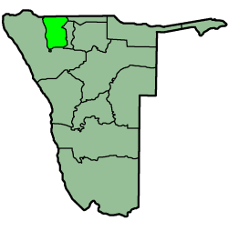
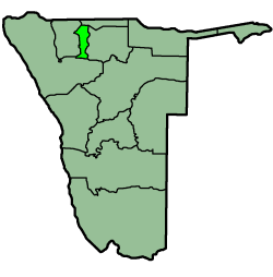
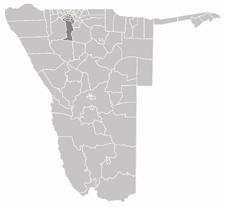
Oshana is one of the fourteen regions of Namibia, its capital is Oshakati. The name Oshana describes the most prominent landscape feature in the area, namely the shallow, seasonally inundated depressions which underpin the local agro ecological system. Although communications are hindered during the rainy season, the fish which breed in the oshanas provide an important source of dietary protein.

Ondangwa Town in Oshana Region, Namibia

Ondangwa is a town of 23,000 inhabitants in the Oshana Region of northern Namibia, bordering Oshikoto Region. Ondangwa was first established as a mission station of the Finnish Missionary Society in 1890. In 1914 it became a local seat of government.

The Diocese of Namibia is part of the Anglican Church of Southern Africa, which is itself part of the Anglican Communion. The diocese, which covers the whole country of Namibia, was originally known as the Diocese of Damaraland. Most of the Anglicans in Namibia live in Ovamboland in the north of the country and speak the Kwanyama language.

Ongwediva Town in Oshana Region, Namibia

Ongwediva is a town in the Oshana Region in the north of Namibia. It is the district capital of the Ongwediva electoral constituency. As of 2010 it had 27,000 inhabitants and covered 4,102 hectares of land. Ongwediva has seven churches, two private schools and 13 government-run schools. Most of the inhabitants speak Oshiwambo.

Okaku Constituency

Okaku Constituency is an electoral constituency in the Oshana Region of Namibia. It has 19,262 inhabitants, its district capital is the settlement of Okaku.

Martti Rautanen Finnish missionary

Martti (Martin) Rautanen was the pioneer of the Finnish Mission in Ovamboland, Namibia.

Omagongati Settlement in Oshana, Namibia

Omagongati is a village situated in the northern part of Namibia in Ondangwa Rural Constituency, Oshana region, it borders the Kingdom of Ondonga from that of Uukwambi, and it is under the leadership of the headman Mr. Noah Nakwfila, well known as Kapinya. Omagongati is as far from Ondangwa as it is from Oshakati, roughly 17 km away and 11km from Ongwediva. It is surrounded by numerous villages, namely Ashaaga, Onelago, Uudhengelo and Okatha, with the nearest town Eheke which has a high school and more improved infrastructures.

Ekuku is a village located nearly 3 kilometres (1.9 mi) north of Oshakati in Okatana Constituency, Oshana Region, Namibia. The mayor of the village is Leevi Shipepe ya Shipepe, and its population is about 3,000.

Iipumbu Ya Tshilongo (1875–1959) was king of the Uukwambi, an Ovambo clan in Namibia, from 1907 to 1932. He is one of the national heroes of Namibia.

Finnish Evangelical Lutheran Mission Lutheran missionary society

The Finnish Evangelical Lutheran Mission is a Lutheran missionary society formed on January 19, 1859, in Helsinki, Finland. It is one of seven organisations of the Evangelical Lutheran Church of Finland (ELCF) that conduct missionary work. Its first deployments outside Finland were made to Ovamboland, an area that today is cut by the Angola-Namibian border.

Nakayale, also known as Nakayale Keengulu is a village in northern Namibia near Outapi in Omusati Region situated 86km northwest of Oshakati and 4km from Outapi. It is in Anamulenge Constituency. The village normally receives an annual average rainfall of 440 millimetres (17 in), although in the 2010/2011 rainy season 723 millimetres (28.5 in) were measured.

Onimwandi is a settlement in the Oshana Region in northern Namibia. It belongs to the Oshakati West electoral constituency and is situated 5 kilometres (3.1 mi) away from Oshakati on the left hand side of the main road on the way to Okahao. The headman of the Oniimwandi village is Mr Erastus Amupolo and his assistant is Mr Juuda Amupolo.

Onandjokwe State Hospital, until 2016 Onandjokwe Lutheran Hospital, is the oldest hospital in the northern part of Namibia. It was built in 1911 by the Finnish Missionary Society under the leadership of Selma Rainio. The hospital was operated by the Evangelical Lutheran Church in Namibia (ELCIN) via Lutheran Medical Services until 2016, when the Government of Namibia took over.

Mpungu Place in Kavango West, Namibia

Mpungu is a settlement and a former mission station of the Finnish Missionary Society in the Mpungu Constituency in the Kavango West Region in Northern Namibia. It is located ca. 40 km south-west of Nkurenkuru, in the inland, as opposed to other former Finnish mission stations, which were located along the Kavango River. Today a tarred highway from Ovamboland to Kavango connects Mpungu to other places in northern Namibia.

Omandongo Place in Oshikoto Region, Namibia

Omandongo is an unpopulated place in the Onayena Constituency in the Oshikoto Region in Northern Namibia, and the region which used to be called Ovamboland.

Ogongo is a settlement in the Omusati Region, in the central North of Namibia. Its neighbouring places include Outapi, Elim and Oshikuku.

Engela Suburb of Helao Nafidi in Engela Constituency, Ohangwena Region, Namibia

Engela is an Ovambo settlement in the Ohangwena Region in northern Namibia. Formerly situated in the Oukwanyama area it is since 2004 part of the town Helao Nafidi, although it still maintained its own village council until the 2015 local authority election. It is one of the more important establishments of the Evangelical Lutheran Church in Namibia (ELCIN) in the area. It started as a mission station of the Finnish Missionary Society. Today, it is the centre of the Engela Constituency.

Okatana, Namibia Place in Ohangwena Region, Namibia

Okatana is a village in the Ohangwena Region in the north of Namibia in the Uukwambi tribal area. It is the centre of the Okatana Constituency.

Albin Savola was a Finnish priest and missionary, who served as the first Finnish missionary Martti Rautanen, a close colleague in Ovamboland and published literature in oshindonga language.

References

  1. "MuAfrica organised tours". Archived from the original on 2011-07-14. Retrieved 2009-11-27.
  2. 1 2 Klaus Dierks. "Chronology of Namibian History, 1870" . Retrieved 2009-11-26.
  3. Veijo Notkola, Ian M. Timaeus and Harri Siiskonen. "Mortality Transition in the Ovamboland Region of Namibia, 1930-1990". 54: 153–167. JSTOR   2584657.Cite journal requires |journal= (help)

Coordinates: 17°42′57″S15°28′53″E / 17.71583°S 15.48139°E / -17.71583; 15.48139

Geographic coordinate system Coordinate system

A geographic coordinate system is a coordinate system that enables every location on Earth to be specified by a set of numbers, letters or symbols. The coordinates are often chosen such that one of the numbers represents a vertical position and two or three of the numbers represent a horizontal position; alternatively, a geographic position may be expressed in a combined three-dimensional Cartesian vector. A common choice of coordinates is latitude, longitude and elevation. To specify a location on a plane requires a map projection.