Elina (Epirus)

Last updated
Epirus in antiquity Map of ancient Epirus and environs (English).svg
Epirus in antiquity

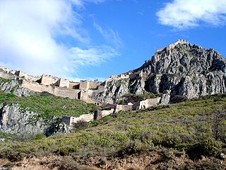
Elina (Greek : Ελίνα) was an ancient Greek, Hellenistic fortified town in the region of Epirus. [1]

Greek language language spoken in Greece, Cyprus and Southern Albania

Greek is an independent branch of the Indo-European family of languages, native to Greece, Cyprus and other parts of the Eastern Mediterranean and the Black Sea. It has the longest documented history of any living Indo-European language, spanning more than 3000 years of written records. Its writing system has been the Greek alphabet for the major part of its history; other systems, such as Linear B and the Cypriot syllabary, were used previously. The alphabet arose from the Phoenician script and was in turn the basis of the Latin, Cyrillic, Armenian, Coptic, Gothic, and many other writing systems.

Ancient Greek Version of the Greek language used from roughly the 9th century BCE to the 6th century CE

The Ancient Greek language includes the forms of Greek used in Ancient Greece and the ancient world from around the 9th century BCE to the 6th century CE. It is often roughly divided into the Archaic period, Classical period, and Hellenistic period. It is antedated in the second millennium BCE by Mycenaean Greek and succeeded by medieval Greek.

Epirus Historical region in Divided between Greece and Albania

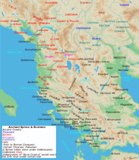
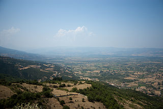
Epirus is a geographical and historical region in southeastern Europe, now shared between Greece and Albania. It lies between the Pindus Mountains and the Ionian Sea, stretching from the Bay of Vlorë and the Acroceraunian mountains in the north to the Ambracian Gulf and the ruined Roman city of Nicopolis in the south. It is currently divided between the region of Epirus in northwestern Greece and the counties of Gjirokastër, Vlorë, and Berat in southern Albania. The largest city in Epirus is Ioannina, seat of the region of Epirus, with Gjirokastër the largest city in the Albanian part of Epirus.

The site is known locally as Dymokastro, west of the village of Perdika. Hammond discussed the site and identified it with ancient Elina. [2] It overlooked the site of the Battle of Syvota between Corcyra (modern Corfu) and Corinth at the start of the Peloponnesian War [3] and was the largest naval battle between Greek city states until that time and was one of the immediate catalysts for the war.

Perdika Place in Greece

Perdika is a village and a former community in Thesprotia, Epirus, Greece. Since the 2011 local government reform it is part of the municipality Igoumenitsa, of which it is a municipal unit. The municipal unit has an area of 34.605 km2.

The Battle of Sybota took place in 433 BC between Corcyra and Corinth, and was, according to Thucydides, the largest naval battle between Greek city states until that time. It was one of the immediate catalysts for the Peloponnesian War.

Corfu Place in Greece

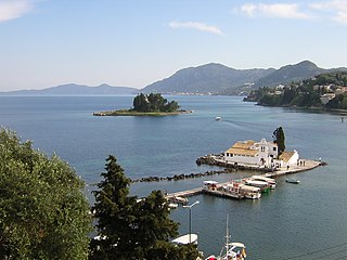
Corfu or Kerkyra is a Greek island in the Ionian Sea. It is the second largest of the Ionian Islands, and, including its small satellite islands, forms the northwesternmost part of Greece. The island is part of the Corfu regional unit, and is administered as a single municipality, which also includes the smaller islands of Ereikoussa, Mathraki and Othonoi. The municipality has an area of 610,9 km2, the island proper 592,8 km2. The principal city of the island and seat of the municipality is also named Corfu. Corfu is home to the Ionian University.

The city flourished from the Late Classical to the Roman times and was named after the Thesprotean tribe of Elinoi that lived in the region. It is estimated that, during the period of its peak, the population of the city reached 6000. The walls are reinforced by rectangular towers and date to the 4th century BC. The west wall was added in the Hellenistic period in order to incorporate the little port into the fortified area. Throughout the settlement are visible foundations of buildings, some of which are hewn from the rock, as well as cisterns, while at the centre of the hilltop is an open space ("Acropolis A") around which were probably clustered the public buildings of the city.

Pausanias may have mentioned the sweet water of this site. [4]

The visible fortifications on Dymokastro date to the Hellenistic period and was excavated over a series of campaigns at the end of the 20th century.

Finds are exhibited at the Archaeological Museum of Igoumenitsa.

Igoumenitsa Place in Greece

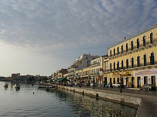
Igoumenitsa, is a coastal city in northwestern Greece. It is the capital of the regional unit of Thesprotia.

See also

Related Research Articles

Ambracia ancient city in Greece

Ambracia, was a city of ancient Greece on the site of modern Arta. It was captured by the Corinthians in 625 BC and was situated about 11 km (7 mi) from the Ambracian Gulf, on a bend of the navigable river Arachthos, in the midst of a fertile wooded plain.

Mantineia Place in Greece

Mantineia was a city in ancient Arcadia, Greece, which was the site of two significant battles in Classical Greek history.

Gytheio Place in Greece

Gytheio or Gythio, also the ancient Gythium or Gytheion, is a town on the eastern shore of the Mani Peninsula, and a former municipality in Laconia, Peloponnese, Greece. Since the 2011 local government reform it is part of the municipality East Mani, of which it is a municipal unit. The municipal unit has an area of 197.313 km2. It was the seaport of Sparta, some 40 kilometres north. Gytheio is the site of ancient Cranae, a tiny island where according to legend Paris of Troy and Helen from Sparta spent their first night together before departing for Troy, thus igniting the Trojan War.

Acrocorinth monolithic rock overseeing the ancient city of Corinth, Greece

Acrocorinth, "Upper Corinth", the acropolis of ancient Corinth, is a monolithic rock overseeing the ancient city of Corinth, Greece. "It is the most impressive of the acropoleis of mainland Greece," in the estimation of George Forrest. Acrocorinth was continuously occupied from archaic times to the early 19th century. Along with Demetrias and Chalcis, the Acrocorinth during the Hellenistic period formed one of the so-called "Fetters of Greece" - three fortresses garrisoned by the Macedonians to secure their control of the Greek city-states. The city's archaic acropolis, already an easily defensible position due to its geomorphology, was further heavily fortified during the Byzantine Empire as it became the seat of the strategos of the thema of Hellas and later of the Peloponnese. It was defended against the Crusaders for three years by Leo Sgouros.

Cichyrus human settlement in Greece

Cichyrus, earlier called Ephyra, was the capital of ancient Thesprotia, according to the myth built by the Pelasgian leader Thesprotos. Thucydides describes it as situated in the district Elaeatis in Thesprotia, away from the sea. At its site is the famous Necromanteion. First settled during the Bronze Age and resettled in the 14th century BC by colonists most probably from Chaonia and the west Peloponnese region. The city is about 800 m north of the junction of the Kokytos River with the Acheron, and about 4.5 km east of the bay of Ammoudia. Near it was the outlet into the sea of the Acherusian Lake. Strabo (7.7.5) gives the same information and adds that in his time Ephyra was called Kichyros. The name had been changed from Ephyra back to the more ancient name about 200 years earlier.

Amantia city

Amantia or Abantia was an ancient Greek polis in Epirus. It occupied an important defensive position above the Aoos river valley to the east, and on the road to the coast and the Bay of Aulon, in Vlorë County of the modern-day Albania. A Greek temple, the Aphrodite temple, a theatre, and a stadium have also been found in the city. The name for an inhabitant was Amantieus.

Orchomenus (Arcadia) ancient Greek city-state of Arcadia

Orchomenus or Orchomenos was an ancient city of Arcadia, Greece, called by Thucydides the Arcadian Orchomenus, to distinguish it from the Boeotian town.

Orestis (region) historical region

Orestis was a region of Upper Macedonia, corresponding roughly to the modern Kastoria regional unit located in West Macedonia, Greece. Its inhabitants were the Orestae, an ancient Greek tribe that was part of the Molossian tribal state, or koinon.

Lepreum ancient city in Ilia

Lepreum or Lepreon, alternately named Lepreus or Lepreos (Λέπρεος) was an Ancient Greek city-state in Triphylia, a district of Elis. It was located 40 stadia away from the sea at the west end of Mount Minthi and built around two citadels. Surrounded by an abundance of natural resources, Lepreum became an important city in the Classical and Hellenistic ages where it became the capital of the Triphylia region. The city has also been identified by some scholars as the mythical city of Aepy, a city described by Homer in the Iliad but never discovered. The ruins of ancient Lepreum have been excavated near the present village Lepreo.

Palairos Place in Greece

Palairos is an ancient city and a modern town in Aetolia-Acarnania, Greece. Since the 2011 local government reform Palairos is part of the municipality Aktio-Vonitsa, of which it is a municipal unit. The municipal unit has an area of 205.843 km2. The municipal unit was formed as the independent municipality Kekropia in 1994 from the former communities Palairos and Pogonia, and was expanded with the former communities Vatos, Plagia and Peratia as a part of the 1997 Kapodistrias reform. The name was changed to Palairos in 2004.

Thoricus or Thorikos was a city, and later a deme in the southern portion of ancient Attica, one of the twelve original settlements that were united in the synoikismos attributed to Theseus to form Archaic Athens. It was later a deme of the phyle of Acamantis. Near it are the mines of Laurion, where lead and silver was mined from Neolithic times, and worked in the industrial quarter of the settlement. There is a theatre dating from c. 525–480 BC. The modern site is Lavrio.

Epirus (ancient state) ancient Greek state

Epirus was an ancient Greek state, located in the geographical region of Epirus in the western Balkans. The homeland of the ancient Epirotes was bordered by the Aetolian League to the south, Thessaly and Macedonia to the east, and Illyrian tribes to the north. For a brief period, the Epirote king Pyrrhus managed to make Epirus the most powerful state in the Greek world, and his armies marched against Rome during an unsuccessful campaign in Italy.

Horreum (Epirus) human settlement in Greece

Horreum or Orraon or Horraon was a Greek city of ancient Epirus. Orraon is located west of the Ammotops. Orraon is located on a hill by the Amorakikos Gulf which is located in Northwestern Greece. It guards the passage all the way down to the Ioannina Basin.

Cheimerium

Cheimerium or Cheimerion was a fortified settlement and harbour of ancient Thesprotia in ancient Epirus, on an eponymous promontory. It lay between the rivers Acheron and Thyamis, and opposite the southern point of Corcyra. In the two naval engagements between the Corcyraeans and Corinthians just before the Peloponnesian War, Cheimerium was the station of the Corinthian fleet.

Regions of ancient Greece

The regions of ancient Greece were areas identified by the ancient Greeks as geographical sub-divisions of the Hellenic world. These regions are described in the works of ancient historians and geographers, and in the legends and myths of the ancient Greeks.

Nisaea or Nisaia was the main port of ancient Megara; the port was sheltered by a natural island called Minoa. According to Thucydides, the distance of the port from Megara itself was about eight Greek stadia. On the road between Megara and Nisaea was a temple of Demeter Malophorus.

Ainis

Ainis or Aeniania, was a region of ancient Greece located near Lamia in modern Central Greece, roughly corresponding to the upper Valley of Spercheios.

Ancient Pydna ancient site

Pydna is an ancient Greek city, an important place in the history of Pieria and a major archaeological site located directly at the Aegean Sea, 16 km northeast of Katerini, 28 km north-east of Dion and 2.5 km from the village of Makrygialos. Nearby are two Macedonian tombs, discovered by the French archaeologist Heuzey during his Greek travels in the mid-19th century. Furthermore, the fortress-like bishop's seat Louloudies is located a few kilometers south of Pydna.

Elaea (Epirus)

Elaea or Elaia, also Elea (Ἐλέα), was a town of Thesprotia in ancient Epirus toward the mouth of the Acheron river. The town is mentioned by Ptolemy. Thucydides calls the surrounding district Elaeatis (Ἐλαιατις) and indicates that Ephyra was in the territory of Elaea. Its port was Elaias Limen, literally the "Bay of Elaea", which the Periplus of Pseudo-Scylax asserts was the main port of Thesprotia.

References

  1. An Inventory of Archaic and Classical Poleis: An Investigation Conducted by The Copenhagen Polis Centre for the Danish National Research Foundation by Mogens Herman Hansen,2005,page 340
  2. N. G. L. Hammond The Journal of Hellenic Studies Vol. 65 (1945), pp. 26-37
  3. Thucydides: Peloponnesian Wars, book 1
  4. Pausanias 7.2

Coordinates: 39°19′48″N20°17′38″E / 39.3300°N 20.2940°E / 39.3300; 20.2940

Geographic coordinate system Coordinate system

A geographic coordinate system is a coordinate system that enables every location on Earth to be specified by a set of numbers, letters or symbols. The coordinates are often chosen such that one of the numbers represents a vertical position and two or three of the numbers represent a horizontal position; alternatively, a geographic position may be expressed in a combined three-dimensional Cartesian vector. A common choice of coordinates is latitude, longitude and elevation. To specify a location on a plane requires a map projection.