
The Nez Percé are an Indigenous people of the Plateau who are presumed to have lived on the Columbia River Plateau in the Pacific Northwest region for at least 11,500 years.

Cow Creek is a tributary of the Missouri River, approximately 35 miles (56 km) long, in north central Montana in the United States. Cow Creek rises in the southern foothills of the Bear Paw Mountains in western Blaine County and flows east and then south, joining the Missouri approximately 25 air miles (40 km) northeast of Winifred, Montana—or 22 miles (35 km) upstream from the Fred Robinson Bridge.
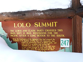
Lolo Pass, elevation 5,233 feet (1,595 m), is a mountain pass in the western United States, in the Bitterroot Range of the northern Rocky Mountains. It is on the border between the states of Montana and Idaho, approximately 40 miles (65 km) west-southwest of Missoula, Montana.

The Nez Perce National Historical Park is a United States National Historical Park comprising 38 sites located across the states of Idaho, Montana, Oregon, and Washington, which include traditional aboriginal lands of the Nez Perce people. The sites are strongly associated with the resistance of Chief Joseph and his band, who in June 1877 migrated from Oregon in an attempt to reach freedom in Canada and avoid being forced on to a reservation. They were pursued by U.S. Army cavalry forces and fought numerous skirmishes against them during the so-called Nez Perce War, which eventually ended with Chief Joseph's surrender in the Montana Territory.
The Battle of Bear Paw was the final engagement of the Nez Perce War of 1877. Following a 1,200-mile (1,900 km) running fight from western Idaho over the previous four months, the U.S. Army managed to corner most of the Nez Perce led by Chief Joseph in early October 1877 in northern Montana Territory, just 42 miles (68 km) south of the border with Canada, where the Nez Perce intended to seek refuge from persecution by the U.S. government.

Big Hole National Battlefield preserves a Nez Perce War battlefield located in Montana, United States. The Nez Perce fought a delaying action against the 7th Infantry Regiment here on August 9 and 10, 1877, during their failed attempt to escape to Canada. This action, the Battle of the Big Hole, was the largest battle fought between the Nez Perce and U.S. Government forces in the five-month conflict known as the Nez Perce War. In 1992 the park was made a part of Nez Perce National Historical Park, which consists of 38 locations in five states, following the flight of the Nez Perce tribe from the U.S. Cavalry, the route of which was designated Nez Perce National Historic Trail in 1986.

Bitterroot National Forest comprises 1.587 million acres (6,423 km²) in west-central Montana and eastern Idaho, of the United States. It is located primarily in Ravalli County, Montana, but also has acreage in Idaho County, Idaho (29.24%), and Missoula County, Montana (0.49%).

This is a directory of properties and districts included among the National Register of Historic Places listings in Idaho. There are approximately 1,000 sites in Idaho listed on the National Register. Each of the state's 44 counties has at least one listing on the National Register.

The Nez Perce (Nee-Me-Poo) National Historic Trail follows the route taken by a large group of the Nez Perce tribe in 1877 to avoid being forced onto a reservation. The 1,170-mile (1,883 km) trail was created in 1986 as part of the National Trails System Act and is managed by the U.S. Forest Service. The trail traverses through portions of the U.S. states of Oregon, Idaho, Wyoming, and Montana and connects sites across these states that commemorate significant events of the Nez Perce War that took place between June and October 1877, as several bands of the Nez Perce tried to escape capture by the U.S. Cavalry. The sites are among the 38 that are part of the National Park service's Nez Perce National Historical Park, managed over all by the National Park Service, with some sites managed by local and state affiliated organizations.
Nez Perce Pass is a mountain pass in the Bitterroot Mountains on the border between the U.S. states of Idaho and Montana. The pass is at an elevation of 6,587 feet (2,008 m) above sea level. The Nez Perce Pass Trailhead offers access to the Selway-Bitterroot Wilderness and the Frank Church—River of No Return Wilderness.

The Wallowa–Whitman National Forest is a United States National Forest in the U.S. states of Oregon and Idaho. Formed upon the merger of the Wallowa and Whitman national forests in 1954, it is located in the northeastern corner of the state, in Wallowa, Baker, Union, Grant, and Umatilla counties in Oregon, and includes small areas in Nez Perce and Idaho counties in Idaho. The forest is named for the Wallowa band of the Nez Perce people, who originally lived in the area, and Marcus and Narcissa Whitman, Presbyterian missionaries who settled just to the north in 1836. Forest headquarters are located in Baker City, Oregon with ranger districts in La Grande, Joseph and Baker City.
Fort Missoula was established by the United States Army in 1877 on land that is now part of the city of Missoula, Montana, to protect settlers in Western Montana from possible threats from the Native American Indians, such as the Nez Perce.

The Camas Meadows Battle Sites, also known as Camas Meadows Camp and Battle Sites, are two sites important to the Battle of Camas Creek, fought August 20, 1877 between members of the Nez Perce tribe and troops of the United States Army. The Nez Perce captured about 150 horses and mules from a campsite of the pursuing army, and for several hours besieged a detachment sent to recover them at a second site. The two sites, each about 40 acres (16 ha) in size, are about 5 miles (8.0 km) apart in Clark County, Idaho. They were designated a National Historic Landmark in 1989, and are now part of Nez Perce National Historical Park, a collection of sites important in Nez Perce history.

Weippe Prairie is a "beautiful upland prairie field of about nine by twenty miles of open farmland bordered by pine forests" at 3,000 feet elevation in Clearwater County, Idaho, at Weippe, Idaho. Camas flowers grow well there, and attracted native gatherers of the camas roots. It is the location in Idaho where the Lewis and Clark Expedition emerged from crossing the Bitterroot Mountains on the Lolo Trail and first met the Nez Perce tribe of Native Americans.

The history of Idaho in the American Civil War is atypical, as the territory was far from the battlefields.

This is a list of the National Register of Historic Places listings in Nez Perce County, Idaho.
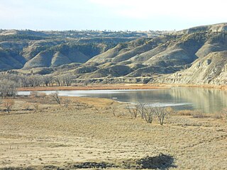
Cow Island lies in a left turning bend of the Missouri River, in the area known as the Missouri River Breaks. The island is formed by sediments that are seasonally washed out from the mouths of Cow Creek and Bull Creek, which enter the Missouri River just upstream from Cow Island. The island is about 1.2 miles long and averages about 150 yards in width. It is located in extreme northern Fergus County, but lies across the river from extreme southern Blaine County, to its east.
The six national parks, reserves, historic sites, and monuments in Idaho contain a wide variety of interesting places and experiences. These include recreational areas, archeological sites, nature preserves and volcanic parks.
The Chief Joseph Trail Ride is an annual horse trail ride that follows the route the Nimiipuu took during the Nez Perce War in 1877. The trail in its entirety is 1,300 miles long, separated into thirteen separate rides, which take place sequentially. The ride is on a 13-year cycle. The trail ride was started in 1965 by the Appaloosa Horse Club.

