Elland Upper Edge is a village on the B6114 road, near the town of Elland, in the Calderdale district, in the English county of West Yorkshire.

Elland Upper Edge is a village on the B6114 road, near the town of Elland, in the Calderdale district, in the English county of West Yorkshire.

Elland Upper Edge has one church, Upper Edge Baptist Church, and a pub, The Rock Tavern.

The River Wharfe is a river in Yorkshire, England. For much of its length it is the county boundary between West Yorkshire and North Yorkshire.

Rastrick is a village in the county of West Yorkshire, England, between Halifax and Huddersfield. The population of the Calderdale Civil Ward at the 2011 census was 11,351. It is perhaps best known for its association, along with its neighbour Brighouse, with the Brighouse and Rastrick Brass Band. Along with Brighouse, it is part of Calderdale, but shares a Huddersfield postcode and phone number.

The West Riding of Yorkshire is one of the three historic subdivisions of Yorkshire, England. From 1889 to 1974 the administrative county, County of York, West Riding, was based closely on the historic boundaries. The lieutenancy at that time included the City of York and as such was named West Riding of the County of York and the County of the City of York.

Wharfedale is one of the Yorkshire Dales. It is situated within the boroughs of Craven and Harrogate in North Yorkshire, and the cities of Leeds and Bradford in West Yorkshire. It is the upper valley of the River Wharfe. Towns and villages in Wharfedale include Buckden, Kettlewell, Conistone, Grassington, Hebden, Bolton Abbey, Addingham, Ilkley, Burley-in-Wharfedale, Otley, Pool-in-Wharfedale, Arthington, Collingham and Wetherby. Beyond Wetherby, the valley opens out and becomes part of the Vale of York.

The Metropolitan Borough of Calderdale is a metropolitan borough of West Yorkshire, England. It takes its name from the dale of the River Calder, whose upper part flows through the borough. Several small valleys contain tributaries of the River Calder. The population at the 2011 Census was 203,826.

Nether Edge and Sharrow Ward includes the districts of Brincliffe, Carter Knowle, Nether Edge, Sharrow Vale, and most of Banner Cross, and is one of the 28 electoral wards in the City of Sheffield, England. It is located in the southern part of the city and covers an area of 1.31 square miles (3.4 km2). In 2011, the population of this ward was 18,890 people in 7,592 households. Nether Edge ward is one of the wards that make up the Sheffield Central parliamentary constituency.

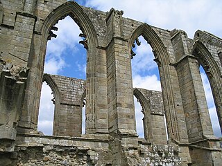
Bolton Abbey is a village and civil parish in the Craven district of North Yorkshire, England, 22 miles (35 km) north-west of Leeds. The village lies in Wharfedale, near the southern edge of the Yorkshire Dales National Park, and just north of the border with West Yorkshire.

Yorkshire Amateur Association Football Club is a football club based in the Potternewton area of Leeds, West Yorkshire, England. They are currently members of the Northern Counties East League Premier Division and play at Bracken Edge.

Skyrack was a wapentake of the West Riding of Yorkshire, England. It was split into upper and lower divisions and centred in Headingley, Leeds. The Lower Division included the parishes of Aberford, Bardsey, Barwick-in-Elmet, Kippax, Thorner, Whitkirk and part of Harewood, while the Upper Division included the parishes of Adel, Bingley, Guiseley and parts of Harewood, Ilkley and Otley.

West Beck is the common name given to the upper section of the old River Hull, as it rises in the foothills of the Yorkshire Wolds. After reaching Frodingham Beck at Emmotland, it becomes called the River Hull. It is noteworthy for being the most northerly chalk stream in England. It provides fly fishing for wild brown trout and grayling.
Elland was a parliamentary constituency in the West Riding of Yorkshire that existed between 1885 and 1950. It elected one Member of Parliament (MP) to the House of Commons, by the first-past-the-post voting system.

The A643 is a main road in West Yorkshire, England.

Thorp Arch is a village and civil parish near Wetherby, West Yorkshire, England in the City of Leeds metropolitan borough.

Huddersfield bus station serves the town of Huddersfield, West Yorkshire, England.

Halifax bus station serves the town of Halifax, West Yorkshire, England. The bus station is owned and managed by Metro (WYPTE). The bus station was opened in 1989 and is made of up 4 large islands with 20 stands in total. The bus station is situated in the Halifax Town Centre and could be accessed from Northgate and Wade Street. Several services, such as the majority of services to Illingworth and Mixenden plus some TJ Walsh services do not serve the bus station and use stops in the town centre.

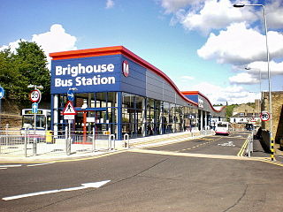
Brighouse bus station serves the town of Brighouse, West Yorkshire, England. The bus station is owned and managed by Metro (WYPTE). The bus station is situated in the Brighouse Town Centre and could be accessed from Gooder Street and Ganny Road. The current station was opened from 10 May 2009 on the site of the previous one that dates back from the 1970s.

Blackley is a hamlet in the Calderdale district, in the county of West Yorkshire, England. It is near the town of Elland, the A629 road and the M62 motorway and can be accessed from junction 24. There is also the village of Ainley Top nearby.

Elland Lower Edge is an area of Rastrick near the town of Brighouse, in the Calderdale District, in the English county of West Yorkshire.

Tyersal Beck is a watercourse in West Yorkshire, England, named after the village of Tyersal in whose vicinity it runs.

The Church of St Mary is a Church of England parish church in Elland, West Yorkshire. The church is a grade I listed building.
Coordinates: 53°40′59″N1°48′50″W / 53.683°N 1.814°W
| This West Yorkshire location article is a stub. You can help Wikipedia by expanding it. |