
North Yarmouth, officially the Town of North Yarmouth, is a town in Cumberland County, Maine, United States. North Yarmouth is included in the Lewiston-Auburn, Maine metropolitan New England city and town area. The population was 4,072 at the 2020 United States Census. It is part of the Portland–South Portland–Biddeford Metropolitan Statistical Area.

Casco Bay is an inlet of the Gulf of Maine on the coast of Maine in the United States. The National Oceanic and Atmospheric Administration's chart for Casco Bay marks the dividing line between the bay and the Gulf of Maine as running from Bald Head on Cape Small in Phippsburg west-southwest to Dyer Point in Cape Elizabeth. The city of Portland and the Port of Portland are on Casco Bay's western edge.

Chebeague Island is located in Casco Bay, an inlet of the Gulf of Maine. It was originally used as a fishing ground by Abenaki Native Americans. Also known as Great Chebeague Island, today it is a town in Cumberland County, Maine, United States. It is located 10 miles (16 km) northeast of Portland, Maine. Chebeague Island is the largest island in Casco Bay that is not connected to the mainland by a bridge. The largest island is Sebascodegan, or "Great Island," which is part of the Town of Harpswell and connected to the mainland via a 100 ft bridge.

The Port of New York and New Jersey is the port district of the New York-Newark metropolitan area, encompassing the region within approximately a 25-mile (40 km) radius of the Statue of Liberty National Monument.

Alexander Wadsworth Longfellow Jr. was an American architect and nephew of poet Henry Wadsworth Longfellow.

The Carrabassett River, a tributary of the Kennebec River, is located in Franklin County and Somerset County, Maine, in the United States. It rises near Sugarloaf Mountain, east of Rangeley Lake, and runs for 33.8 miles (54.4 km), flowing southeast past Kingfield and joining the Kennebec River in the town of Anson.
Snodgrass is a surname of Scottish origin. It may also refer to the following places:

Cousins Island is an island in Casco Bay within the town of Yarmouth in Cumberland County, Maine, United States. It is listed as a census-designated place, with a population of 490 as of the 2010 census. The CDP is part of the Portland–South Portland–Biddeford, Maine Metropolitan Statistical Area.

Yarmouth is a town in Cumberland County, Maine, United States, twelve miles north of the state's largest city, Portland. When originally settled in 1636, as North Yarmouth, it was part of the Massachusetts Bay Colony, and remained part of its subsequent incarnations for 213 years. In 1849, twenty-nine years after Maine's admittance to the Union as the twenty-third state, it was incorporated as the Town of Yarmouth.

Littlejohn Island is an island and census-designated place (CDP) in the town of Yarmouth in Cumberland County, Maine, United States. The population of the CDP was 118 at the 2010 census.
The West Side Trail is a multi-use trail in Yarmouth, Maine. A Town of Yarmouth project conceived in 1988 and opened in 2014, the trailhead for the eastern portion of the trail is in the parking lot of Tyler Technologies, on Tyler Drive, on the eastern side of U.S. Route 1, immediately before the exit 15 northbound on-ramp to Interstate 295 (I-295). The trailhead for the western section is in the park and ride lot at the southbound exit 15 ramp for I-295, to the west of Route 1.
The historical buildings and structures of Yarmouth, Maine, represent a variety of building styles and usages, largely based on its past as home to almost sixty mills over a period of roughly 250 years. These mills include that of grain, lumber, pulp and cotton. Additionally, almost three hundred vessels were launched by Yarmouth's shipyards in the century between 1790 and 1890, and the homes of master shipwrights and ship captains can still be found throughout the town.

Royal River Park is an urban park in Yarmouth, Maine, United States. It is located to the northwest of the town center, between East Elm Street to the west and Bridge Street to the east. U.S. Route 1 runs through the park via an overpass.

The First Falls are the first of four waterfalls in Yarmouth, Maine, United States. They are located on the Royal River, approximately a mile from its mouth with inner Casco Bay at Yarmouth Harbor and around 0.35 miles (0.56 km) downstream of the Second Falls. The river appealed to settlers because its 45-foot rise in close proximity to navigable water each provided potential waterpower sites. As such, each of the four falls was used to power 57 mills between 1674 and the mid-20th century.
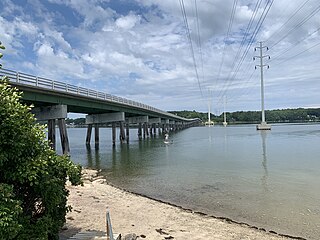
White's Cove is a cove in Yarmouth, Maine, United States. It is around 0.53 miles (0.85 km) across at its widest point, in the inner waters of Casco Bay. It sits directly north of the Ellis C. Snodgrass Memorial Bridge. Whites Cove Road, off Gilman Road, leads to the cove.
Gilman Road is a prominent street in Yarmouth, Maine, United States. It runs for about 1.7 miles (2.7 km) from Lafayette Street in the northwest to the Ellis C. Snodgrass Memorial Bridge at White's Cove in the southeast. At the bridge, which connects the Yarmouth mainland to Cousins Island, the road becomes Cousins Road.
Martin's Point Bridge spans the Presumpscot River in Maine, United States, near the river’s mouth with Casco Bay. It connects Falmouth Foreside, at Mackworth Point, in the north, to the East Deering neighborhood of Portland, at Martin's Point, in the south. 1,300 feet (400 m) in length, it carries vehicular and pedestrian traffic of U.S. Route 1. The bridge is two lanes, including a bicycle lane in each, with a pedestrian lane on the eastern side. A similar plan for the western side of the bridge was abandoned.

Drinkwater Point Road is a prominent street in Yarmouth, Maine, United States. One of the first streets laid out in what was then coastal North Yarmouth, Province of Massachusetts Bay, it runs for about 0.45 miles (0.72 km) from Gilman Road in the north to Seaborne Drive in the south. Drinkwater Point faces Cousins Island, to which it is connected by the Ellis C. Snodgrass Memorial Bridge, and overlooks inner Casco Bay.
The Beth Condon Memorial Pathway is a recreation path in Yarmouth, Maine, United States. It is named in memory of 15-year-old Yarmouth High School sophomore Elizabeth Ann Condon, who was killed by drunk driver Martha Burke in 1993 as she walked along U.S. Route 1 with her boyfriend, James Young, having just been to a video store in Yarmouth Marketplace. Burke's car swerved into the breakdown lane, and while Young managed to avoid the car, Condon was hit and thrown 65 feet (20 m) over the guardrail and down an embankment. Burke pleaded guilty to manslaughter and was sentenced to twelve years, with eight years suspended.
Drinkwater Point is a promontory in Yarmouth, Maine, United States. It is located 2.35 miles (3.78 km) southeast of Yarmouth Village and looks out into inner Casco Bay and Cousins Island. Gilman Road leads to the point itself, where the Ellis C. Snodgrass Memorial Bridge connects mainland Yarmouth to Cousins Island.

