Related Research Articles

Dunedin is the second-largest city in the South Island of New Zealand, and the principal city of the Otago region. Its name comes from Dùn Èideann, the Scottish Gaelic name for Edinburgh, the capital of Scotland. The city has a rich Māori, Scottish, and Chinese heritage.
Caversham is an association football club based in Dunedin, New Zealand. They compete in the ODT FootballSouth Premier League.
Roslyn-Wakari Association Football Club is an association football club based in Dunedin, New Zealand. They compete in the FootballSouth Premier League.
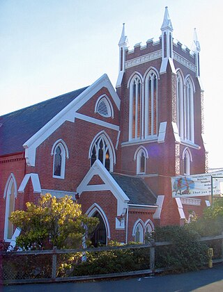
Kaikorai Presbyterian Church is a Presbyterian congregation of the PCANZ Presbyterian Church of Aotearoa New Zealand located in Kaikorai, a suburb of Dunedin, New Zealand.

Logan Park is a sporting venue in the city of Dunedin, New Zealand. It lies on land reclaimed from the former Lake Logan.
Roslyn is a suburb in the city of Palmerston North, Manawatū-Whanganui, New Zealand.
The Southern Premier League is a New Zealand association football league competition administered by Southern Football involving clubs from the lower half of the South Island of New Zealand. Five of the clubs are from Dunedin and one each are from Wānaka, Queenstown, Mosgiel, Timaru, and Invercargill.
Wakari is a residential suburb of the New Zealand city of Dunedin. It is located 2.5 kilometres (1.6 mi) to the northwest of the city centre, immediately to the west of the ridge which runs to the west of the city's centre. Wakari lies to the north of the upper reaches of the Kaikorai Valley, and is also north of the suburb of Kaikorai. The suburbs of Roslyn and Maori Hill are situated on the ridge immediately to the southeast and east of Wakari. The suburb of Halfway Bush lies to the northwest, and the smaller suburb of Helensburgh lies to the north.
Waldronville is a coastal settlement on the Pacific Ocean coast of the South Island of New Zealand. Established in the 1950s as a commuter settlement, it is located 13 kilometres (8.1 mi) to the southwest of Dunedin city centre, and lies within the city's limits. Waldronville was developed by Bill Waldron, when he purchased the McCraws farm in the early 1950s, initially for 200 houses. In the mid-1970s, two other streets were added to the southwest of the settlement. In the mid-1990s, Friendship Drive and Wavy Knowes developments were added to the northeast.

Māori Hill is a residential suburb of the New Zealand city of Dunedin. It is located at the northern end of the ridge which runs in a crescent around the central city's western edge, 2 kilometres (1.2 mi) to the northwest of the city centre, immediately above and within the Town Belt. It is connected to Dunedin North, which lies to the east, via Drivers Road, the suburbs of Roslyn and Kaikorai to the southwest via Highgate, and the suburb of Wakari to the northwest via Balmacewen Road.
Sunnyvale Park is a multi-use sports venue in Dunedin, New Zealand. It is located immediately to the west of Abbotsford in Sunnyvale, near Green Island, and is bounded by Main South Road, Dunedin Southern Motorway and Abbot's Creek, a tributary of the Kaikorai Stream.

Halfway Bush is a suburb of the New Zealand city of Dunedin. It is located 3 kilometres (1.9 mi) to the northwest of the city centre, close to the point at which Taieri Road becomes the winding rural Three Mile Hill Road. It was this road which gave the suburb its name, as this locality was halfway between the Taieri Plains and central Dunedin in the early days of European settlement, when Three Mile Hill was the main route from Dunedin to the Otago hinterland. This route was superseded by the route through the Caversham Valley in the 1860s.

Roslyn is a major residential and retail suburb of the New Zealand city of Dunedin. It is located 150 metres (490 ft) above the city centre on the ridge which runs in a crescent around the central city's western edge. It is 2.5 kilometres (1.6 mi) to the northwest of the city centre, immediately above the Town Belt.
Brockville is a residential suburb of the New Zealand city of Dunedin. It is located at the edge of the city's main urban area, 5.5 kilometres (3.4 mi) to the northwest of the city centre, but separated from it by both a ridge of hills and the Kaikorai Valley.

The Kaikorai Stream is a short river which runs through the city of Dunedin, in New Zealand's South Island. The stream has origins in the northwestern suburbs of Dunedin, flowing southwest towards the Kaikorai Lagoon.
Kaikorai Valley is a long broad valley which runs through the west of the New Zealand city of Dunedin, 5 kilometres (3.1 mi) to the west of the city centre. It is the valley of a small stream, the Kaikorai Stream, which runs from northeast to southwest down the length of the valley.

The Caledonian Ground, often simply known as "The Caley", is a major sports venue in the New Zealand city of Dunedin. It is primarily used for football (soccer) and athletics, and has a capacity of 7,500.

The Kensington Oval, formerly known as the South Dunedin Recreation Ground, is a park and sports ground in Kensington, Dunedin, New Zealand. It is also known as just The Oval, although this name has become less common in recent years due to the potential confusion with the University Oval in the north of the city.
The Fletcher Cup is a New Zealand association football league competition administered by Southern Football involving clubs from the lower half of the South Island of New Zealand. All eight of the teams in the competition in 2024 with the exception of Mosgiel AFC and Old Boys' AFC — are from Dunedin, with several of them being second teams from clubs in higher divisions. The league sits at level 4 of the New Zealand football pyramid.
The Women's South Island League is an amateur status league competition run by Southern Football and Mainland Football for Association football clubs located in the South Island of New Zealand. It is at the second level of New Zealand Football behind the national association based New Zealand Women's National League, and the highest level of club based football available to teams within the region.
References
- ↑ Index card of purchase, Dunedin Recollect collection of Dunedin Public Libraries. Retrieved 7 June 2024
- ↑ "Ellis Park". Dunedin City Council . Retrieved 7 June 2024.
45°52′00″S170°28′36″E / 45.86667°S 170.47667°E
| | This article about a sports venue in New Zealand is a stub. You can help Wikipedia by expanding it. |