
North West Leicestershire is a local government district in Leicestershire, England. The towns in the district include of Ashby-de-la-Zouch, Castle Donington, Coalville and Ibstock. Notable villages in the district include Donington le Heath, Ellistown, Hugglescote, Kegworth, Measham, Shackerstone, Thringstone and Whitwick.

Hinckley and Bosworth is a constituency represented in the House of Commons of the UK Parliament since 2019 by Luke Evans, a Conservative.

Bardon Mill is a small village in Northumberland, within the vicinity of the ancient Hadrian's Wall. It is located around 10+1⁄2 miles from Hexham, 26+1⁄2 mi (43 km) from Carlisle, and 32 mi (51 km) from Newcastle upon Tyne.
Stoughton is a village and civil parish in the Harborough district of Leicestershire. The population at the 2011 census was 351.
Clawson, Hose and Harby is a civil parish in Leicestershire, England, forming part of the Melton district. It contains the villages of Harby, Hose and Long Clawson and the parish was created from those former parishes on 1 April 1936. The population of the civil parish at the 2011 census was 2,577.

Charley is a civil parish located in the North West Leicestershire district of Leicestershire, England. According to the 2001 census, it had a population of 203, increasing to 236 at the 2011 census. It is set within the Charnwood Forest.

Aslackby and Laughton is a civil parish in the South Kesteven district of Lincolnshire, England. According to the 2001 census the parish had a population of 243, in 102 households. increasing slightly to 251 in 118 households at the 2011 census. It consists of the village of Aslackby, the hamlet of Laughton, and scattered farms, and part of the hamlet of Graby.
Oakthorpe and Donisthorpe or Oakthorpe, Donisthorpe and Acresford is a civil parish in the North West Leicestershire district of Leicestershire, England. According to the 2001 census it had a population of 2,336, increasing to 2,637 at the 2011 census. It includes Oakthorpe and Donisthorpe.

Bardon is a civil parish and former village in North West Leicestershire about 1.5 miles (2.4 km) southeast of the centre of Coalville. The parish includes Bardon Hill, which at 912 feet (278 m) above sea level is the highest point in Leicestershire. With the population remaining less than 100, information from the 2011 census was included in the civil parish of Ellistown and Battleflat.

Stanton-under-Bardon is a village and civil parish about 4 miles (6.4 km) southeast of Coalville, in the Hinckley and Bosworth district, in Leicestershire, England. The 2011 Census recorded the parish's population as 634.

Ellistown Football Club is a football club based in the village of Ellistown, near Coalville in Leicestershire, England. They are currently members of the Leicestershire Senior League Premier Division and play at Terrace Road.
Ellistown is a village about 2 miles (3 km) south of Coalville in North West Leicestershire, England. It is named after Colonel Joseph Joel Ellis who died in 1885. The population from the 2011 census was included in the civil parish of Ellistown and Battleflat.

Brailsford is a small red-brick village and civil parish in Derbyshire on the A52 midway between Derby and Ashbourne. The parish also includes Brailsford Green. The civil parish population at the 2011 Census was 1,118. The village has a pub, a golf club, a post office and a school. There are many fine houses in the district including two 20th-century country houses: Brailsford Hall built in 1905 in Jacobean style, and Culland Hall.

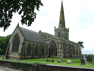
Swannington is a former mining village situated between Coalville and Ashby-de-la-Zouch, Leicestershire, England. A document of 1520 mentions five pits at Swannington. It was a terminus of the early (1832) Leicester and Swannington Railway that was built to serve the townships of Swannington and Thringstone and is built on a spot reputedly chosen by William Wordsworth, a frequent guest of Sir George Beaumont of nearby Coleorton Hall. It is possible that the dedication of the church to Saint George is derived from its association with this George Beaumont.

Church Broughton is a village and civil parish in Derbyshire, 13.7 miles (22.0 km) to the west of Derby. It has a church and a Methodist chapel (1828). Badway Green is a piece of common land within the parish. It is an isolated village surrounded by farmland.

Coleorton is a village and civil parish in North West Leicestershire, England. It is situated on the A512 road approximately 2 miles (3.2 km) east of Ashby de la Zouch. Nearby villages include Newbold, to the north, Thringstone to the east, and Swannington to the south-east.
Chilcote is a village and civil parish in the North West Leicestershire district of Leicestershire, England. Until 1897 it was in Derbyshire. The parish had a population of 108 according to the 2001 census, including Stretton-en-le-Field and increasing to 200 at the 2011 census.

Lockington-Hemington is a civil parish in the North West Leicestershire district of Leicestershire, England. The parish includes the villages of Hemington and Lockington. According to the 2001 census it had a population of 556, rising to 838 at the 2011 census.
Mapperley is a village and civil parish in the Amber Valley district of Derbyshire, England, situated 7 miles (11 km) northeast of Derby and 2 miles (3 km) northwest of Ilkeston. In the 2001 census it had a population of 253, increasing to 289 at the 2011 Census.
Hugglescote and Donington le Heath is a civil parish in North West Leicestershire, England. It includes the villages of Hugglescote and Donington le Heath, each of which is about 1 mile (1.6 km) south of the centre of Coalville. The population of the civil parish at the 2011 census was 4,446.