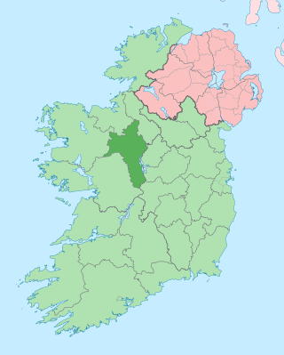
County Roscommon is a county in Ireland. It is part of the province of Connacht and the Northern and Western Region. It is the 11th largest Irish county by area and 27th most populous. Its county town and largest town is Roscommon. Roscommon County Council is the local authority for the county. The population of the county was 69,995 as of the 2022 census.
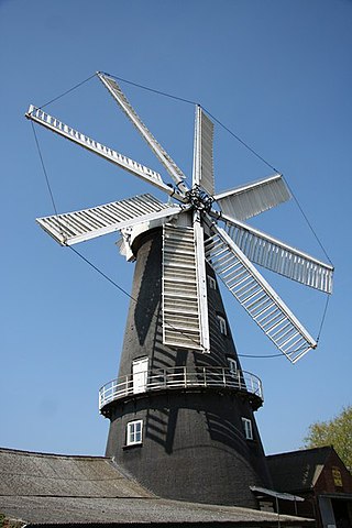
Heckington Windmill is the only eight-sailed tower windmill still standing in the United Kingdom with its sails intact.

Strokestown, also known as Bellanamullia and Bellanamully, is a small town in County Roscommon, Ireland. It is one of the 27 designated Heritage Towns in Ireland. Located in the part of the country marketed for tourism purposes as Ireland's Hidden Heartlands, it is 140 km (87 mi) from Dublin and 120 km (75 mi) from Galway. Strokestown is one of Ireland's few planned towns, showing evidence of deliberate planning, such as formally aligned streets and prominent public buildings.

Maud Foster Windmill is a seven-storey, five sail windmill located by the Maud Foster Drain in Skirbeck, Boston, Lincolnshire, from which she is named. She is one of the largest operating windmills in England being 80 feet (24.38 m) tall to the cap ball.

Ballintra is a village in the parish of Drumholm in the south of County Donegal, Ireland, just off the N15 road between Donegal town and Ballyshannon. Ballintra lies on the northern bank of the Blackwater river. The river rises in the hills that lie inland from the town, and flows through a number of small lakes before spilling over a small waterfall in a gorge behind the village.
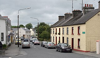
Elphin is a small town in north County Roscommon, Ireland. It forms the southern tip of a triangle with Boyle 18 km (11 mi) and Carrick-on-Shannon 14 km (9 mi) to the north west and north east respectively. It is at the junction of the R368 and R369 regional roads. Ireland West Airport Knock is 50 km (31 mi) west of Elphin - approximately 40 minutes by road.
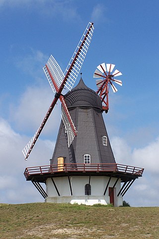
The smock mill is a type of windmill that consists of a sloping, horizontally weatherboarded, thatched, or shingled tower, usually with six or eight sides. It is topped with a roof or cap that rotates to bring the sails into the wind. This type of windmill got its name from its resemblance to smocks worn by farmers in an earlier period.
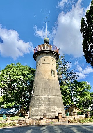
The Old Windmill is a heritage-listed tower mill in Observatory Park adjacent to Wickham Park at 226 Wickham Terrace, Spring Hill, City of Brisbane, Queensland, Australia. It was built in the 1820s by convict labour in the Moreton Bay penal settlement and is the oldest surviving building in Queensland. It is also known as Brisbane Observatory and Windmill Tower. It was added to the Queensland Heritage Register on 21 October 1992. Today it is the centrepiece of Observatory Park and a lookout over parts of the Brisbane CBD.

Boyle Abbey is a ruined Cistercian friary located in Boyle, County Roscommon, Ireland. It was founded by Saint Malachy in the 12th century.
The Clayton Windmills, known locally as Jack and Jill, stand on the South Downs above the village of Clayton, West Sussex, England. They comprise a post mill and a tower mill, and the roundhouse of a former post mill. All three are Grade II* listed buildings.

The United Dioceses of Kilmore, Elphin and Ardagh is a diocese of the Church of Ireland located in central Ireland. It is in the ecclesiastical province of Armagh.

The N61 road is a national secondary road in County Roscommon in Ireland, linking Athlone, Roscommon, Tulsk, and Boyle. It also connects the N6, N63, N60, N5, and N4 national primary and national secondary roads, as well as seven regional roads. The road is 74.193 kilometres (46.101 mi) long.

Ardcarn or Ardcarne, is a civil parish in County Roscommon, Ireland.

Cromer Windmill, restored in four stages between 1967 and 1998, is a Grade II* listed post mill at Cromer, Ardeley, Hertfordshire, England.

Quainton Windmill is a historic windmill in the village of Quainton, Buckinghamshire, England, United Kingdom.

Scregg House is an 18th century house in the townland of Scregg, south of Knockcroghery, in County Roscommon, Ireland. It was built in 1769 and occupied by J.E. Kelly in 1837 and Eliza Kelly in the 1850s. In a sale rental document of 1856, the house is described as a "respectable mansion, 3 stories high with basement and attic stories and a view of the Shannon River". Occupied in 1906 by the representatives of Henry Potts, the house is extant but no longer occupied. It is included on Roscommon County Council's Record of Protected Structures. Between 2007 and 2009, the Irish Georgian Society provided grant funding for repairs to the house's roof and windows.

Hickling Mill is a 19th-century grade II* listed windmill in Hickling Heath, Norfolk, England.

Vinegar Hill Windmill or Templeshannon Windmill is a tower mill on Vinegar Hill, Enniscorthy, County Wexford.

Castlecoote(otherwise known in Irish: Bhaile Mhic Oireachtaigh) is a townland within the civil parish of Fuerty on the R366 regional road near the town of Roscommon in County Roscommon, Ireland. Castlecoote is known for Castlecoote house and the ruins of a much older castle. The River Suck, which encircles Castlecoote House, is renowned for its trout and coarse fishing.

Ballinameen is a small village and census town in County Roscommon, Ireland. Located in the historical barony of Frenchpark on the R370 regional road, the village had a population of 191 people as of the 2016 census.


