Related Research Articles

Andorra is a small, landlocked country in southwestern Europe, located in the eastern Pyrenees mountain range and bordered by Spain and France. With an area of 468 km², it is the sixth smallest country in Europe and also the largest of the European microstates.

Pallars Jussà is a comarca (county) in Catalonia, Spain. It was established as a comarca in 1936, out of the old county of Pallars. The name means "Lower Pallars"; to the northeast and into the mountains is Pallars Sobirà. Its capital and largest municipality is Tremp.

Alt Empordà is a comarca (county) in Girona, Catalonia, Spain, one of two into which Empordà was divided by the comarcal division of Catalonia in 1936, the other one being Baix Empordà.

Ripollès is a comarca (county) in Catalonia, Spain. It is located in the Ribes and Camprodon river valleys. In 2001, its population was 25,744, about 40% of whom lived in the capital, Ripoll.

Tarragonès is a comarca (county) in Catalonia, Spain. It is one of the three comarques formed in the 1936 comarcal division of Camp de Tarragona. It lies on the Mediterranean coast, between the comarques of Baix Penedès to the northeast and Baix Camp to the south. Over 60% of the population live in the capital, Tarragona.
Amlia is an island in the Aleutian Islands. It is located near the eastern end of the Andreanof Islands and is situated between Atka Island and Seguam Island.
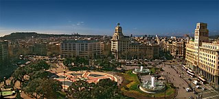
Plaça de Catalunya is a large square in central Barcelona that is generally considered to be both its city centre and the place where the old city and the 19th century-built Eixample meet.

The Barcelona–Vallès Line is an unconnected standard gauge rapid transit and commuter railway line linking Barcelona with Sabadell and Terrassa via the Collserola mountain range, in Catalonia, Spain. Its name refers to the Catalan historical region of Vallès, whereby most part of the line runs. Plaça de Catalunya station serves as the Barcelona terminus of the line, where almost all its trains either start or terminate. The line then continues northwards and branches off twice before leaving the city limits. Its main route splits in two in Sant Cugat del Vallès, forming two major branches to Sabadell and Terrassa. It has 40 passenger stations in operation and a total line length of 48.1 kilometres (29.9 mi).
The Communauté d'agglomération de la région Dieppoise, also known as Dieppe Maritime is the communauté d'agglomération, an intercommunal structure, centred on the city of Dieppe. It is located in the Seine-Maritime department, in the Normandy region, northern France. It was created on 31 December 2002. Its area is 129.0 km2. Its population was 46,223 in 2018, of which 28,561 in Dieppe proper.

The following outline is provided as an overview of and topical guide to Catalonia:

Gradski stadion Lapad (Croatian pronunciation: [grǎtskiː stâdijoːn lǎpad]0 is a football stadium located in Dubrovnik, Croatia. It was built in 1919 and serves as home stadium for NK GOŠK Dubrovnik football club. The stadium has a capacity of 3,000 spectators.
Crnatovo is a village in the municipality of Vlasotince, Serbia. According to the 2002 census, the village has a population of 176 people.
Sant Sepulcre de Palera is a Benedictine monastery in Beuda, in the comarca of Garrotxa, Province of Girona, Catalonia, Spain. The priory was consecrated by Bishop Berengar of Berga in 1085, with the assistance of the bishops of Barcelona, Carcassonne, Albi and Elne. In 1107 it became part of the monastery of Santa Maria de la Grasse until the sixteenth century, when it became a pilgrimage centre known as Santo Domingo de Palera. In 1936 the temple was desecrated and several figures and parts of altarpieces disappeared. It became a Bien de Interés Cultural site on 24 September 1964.
Santa Cecília de Elins is a former Romanesque Benedictine monastery in the municipality of Montferrer i Castellbò, Catalonia, Spain, to the southeast of the village of Cassovall. It is a Bien de Interés Cultural site. The monastery was documented in 865 but fell into decline in the tenth century. On 29 December 1080 the Bishop of Urgell Bernat Guillem consecrated a new church with three altars dedicated to St. Cecilia, Virgin Mary and Santa Fe. During the fourteenth century it fell into decline and in 1383 it was reduced in status to a priory. By 1680 the monastery fell into ruins. It was converted into a farmhouse in the 1940s.

Sant Pere del Burgal is a Romanesque Benedictine monastery in Escaló, in the municipality of La Guingueta d'Àneu, Pallars Sobirà, Catalonia, Spain. The monastery was first mentioned in a precept of Count Raymond of Toulouse in 859. It later became a priory of the abbey of Roussillon. It fell into decline and was secularized in 1570 and confiscated in 1835. It contains frescoes dated to the 11th century.

Sant Pere de Graudescales is a Romanesque Benedictine monastery in La Valldora, in the municipality of Navès, Solsonès, in the Province of Lleida, Catalonia, Spain. It lies to the north of Navès and west of Berga. It was consecrated in 913 by the Bishop of Urgell. From the fifteenth century it was used as a parish church until 1837 when it was abandoned and gradually fell into ruin. Sant Pere de Graudescales was excavated and restored during the second half of the 20th century.

Sant Pere de les Maleses is a Benedictine cave monastery in the municipality of La Pobla de Segur, Pallars Jussà, in the Province of Lleida, Catalonia, Spain. the monastery was first mentioned in 868 when it was dedicated to St. Andrew and was donated to St. Vincent of Oveix, the abbot of Attila. During the tenth or eleventh century it ceased to be owned by Oveix and was rededicated to St. Peter. It later fell under ownership of Santa Maria de Gerri, and lost its status as a monastery. It was secularized in 1592 and from then on became a simple church.
Kızılliman is a Mediterranean headland in Turkey known for the ruins of ancient stone quarry Melenie.
References
- ↑ "Mapa Topogràfic de Catalunya". Institut Cartogràfic de Catalunya. Retrieved May 22, 2010..
42°04′43″N2°09′12″E / 42.07861°N 2.15333°E
| | This article about a location in Catalonia is a stub. You can help Wikipedia by expanding it. |