
The Port of Los Angeles is a seaport managed by the Los Angeles Harbor Department, a unit of the City of Los Angeles. It occupies 7,500 acres (3,000 ha) of land and water with 43 miles (69 km) of waterfront and adjoins the separate Port of Long Beach. Promoted as "America's Port", the port is located in San Pedro Bay in the San Pedro and Wilmington neighborhoods of Los Angeles, approximately 20 miles (32 km) south of downtown.

The Inner Harbor is a historic seaport, tourist attraction, and landmark in Baltimore, Maryland. It was described by the Urban Land Institute in 2009 as "the model for post-industrial waterfront redevelopment around the world". The Inner Harbor is located at the mouth of Jones Falls, creating the wide and short northwest branch of the Patapsco River. The district includes any water west of a line drawn between the foot of President Street and the American Visionary Art Museum.

The Embarcadero is the eastern waterfront of Port of San Francisco and a major roadway in San Francisco, California. It was constructed on reclaimed land along a three mile long engineered seawall, from which piers extend into the bay. It derives its name from the Spanish verb embarcar, meaning "to embark"; embarcadero itself means "the place to embark." The Central Embarcadero Piers Historic District was added to the National Register of Historic Places on November 20, 2002.
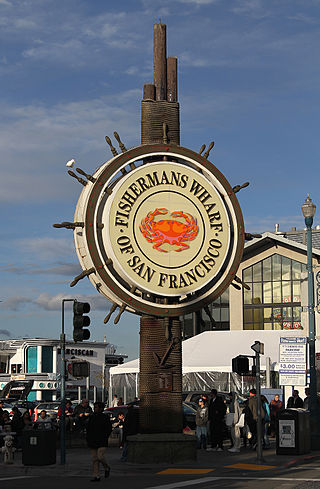
Fisherman's Wharf is a neighborhood and popular tourist attraction in San Francisco, California, United States. It roughly encompasses the northern waterfront area of San Francisco from Ghirardelli Square or Van Ness Avenue east to Pier 35 or Kearny Street. The F Market streetcar runs through the area, the Powell / Hyde cable car line runs to Aquatic Park, at the edge of Fisherman's Wharf, and the Powell / Mason cable car line runs a few blocks away.
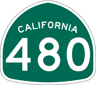
State Route 480 was a state highway in San Francisco, California, United States, consisting of the elevated double-decker Embarcadero Freeway, the partly elevated Doyle Drive approach to the Golden Gate Bridge and the proposed and unbuilt section in between. The unbuilt section from Doyle Drive to Van Ness Avenue was to have been called the Golden Gate Freeway and the Embarcadero Freeway as originally planned would have extended from Van Ness along the north side of Bay Street and then along the Embarcadero to the San Francisco-Oakland Bay Bridge.

The San Francisco Ferry Building is a terminal for ferries that travel across the San Francisco Bay, a food hall and an office building. It is located on The Embarcadero in San Francisco, California and is served by Golden Gate Ferry and San Francisco Bay Ferry routes.

Penn's Landing is a waterfront area of Center City Philadelphia, Pennsylvania, situated along the Delaware River. Its name commemorates the landing of William Penn, the founder of Pennsylvania, in 1682. The actual landing site is farther south, in Chester. The city of Philadelphia purchased the right to use the name. Penn's Landing is bounded by Front Street to the west, the Delaware River to the east, Spring Garden Street to the north, and Washington Avenue to the south, and is primarily focused on the Christopher Columbus Boulevard corridor.

Seaport Village is a waterfront shopping and dining complex adjacent to San Diego Bay in downtown San Diego, California. The complex houses more than 70 shops, galleries, and eateries on 90,000 square feet (8,000 m2) of waterfront property. It contains several freestanding buildings in an assortment of architectural styles, from Victorian to traditional Mexican.

The Port of San Francisco is a semi-independent organization that oversees the port facilities at San Francisco, California, United States. It is run by a five-member commission, appointed by the Mayor subject to confirmation by a majority of the Board of Supervisors. The Port is responsible for managing the larger waterfront area that extends from the anchorage of the Golden Gate Bridge, along the Marina district, all the way around the north and east shores of the city of San Francisco including Fisherman's Wharf and the Embarcadero, and southward to the city line just beyond Candlestick Point. In 1968, the State of California, via the California State Lands Commission for the State-operated San Francisco Port Authority, transferred its responsibilities for the Harbor of San Francisco waterfront to the City and County of San Francisco / San Francisco Harbor Commission through the Burton Act AB2649. All eligible State port authority employees had the option to become employees of the City and County of San Francisco to maintain consistent operation of the Port of San Francisco.

North Coast Harbor is a district in downtown Cleveland, Ohio, United States, on the shore of Lake Erie. The district serves as the home of the Great Lakes Science Center, the Rock and Roll Hall of Fame and Museum, FirstEnergy Stadium, the Steamship William G. Mather Maritime Museum, USS Cod, Burke Lakefront Airport, Voinovich Bicentennial Park, and the Cleveland-Cuyahoga County Port Authority. It is served by the West 3rd and North Coast stations on RTA's light rail Waterfront Line.

Downtown San Diego is the central business district of San Diego, California, the eighth largest city in the United States. It houses the major local headquarters of the city, county, state, and federal governments. The area comprises seven districts: Gaslamp Quarter, East Village, Columbia, Marina, Cortez Hill, Little Italy, and Core.

Marina is a neighborhood in the southwest section of downtown San Diego, California, along San Diego Bay. It comprises a district of retail and entertainment complexes, such as the Rady Shell at Jacobs Park, Seaport Village, and the San Diego Convention Center.

Columbia is a neighborhood in downtown San Diego, California. It is largely commercial, however there are many high-rise condominium buildings under construction.

Middle Harbor Shoreline Park (MHSP) is located on San Francisco Bay and the Oakland Seaport entrance channel, west of downtown Oakland, California. It is owned and operated by the Port of Oakland. The park entrance is at the intersection of 7th Street and Middle Harbor Road. It is open seven days a week from 8 a.m. to dusk.

The Central Embarcadero Piers Historic District is a Registered Historic District in the city of San Francisco, California, United States. It consists of Piers 1, 1½, 3 and 5, which form one of the largest surviving pier complexes along San Francisco's Embarcadero waterfront road. It was added to the National Register of Historic Places in 2002.

Pier 70 in San Francisco, California, is a historic pier in San Francisco's Potrero Point neighborhood, home to the Union Iron Works and later to Bethlehem Shipbuilding. It was one of the largest industrial sites in San Francisco during the two World Wars. Today, it is regarded as the best-preserved 19th century industrial complex west of the Mississippi.

The Central Waterfront is a neighborhood of Seattle, Washington. It is the most urbanized portion of the Elliott Bay shore. It runs from the Pioneer Square shore roughly northwest past Downtown Seattle and Belltown, ending at the Broad Street site of the Olympic Sculpture Park.

The East River Greenway is an approximately 9.44-mile-long (15.19 km) foreshoreway for walking or cycling on the east side of the island of Manhattan on the East River. It is part of the Manhattan Waterfront Greenway. The largest portions are operated by the New York City Department of Parks and Recreation. It is separated from motor traffic, and many sections also separate pedestrians from cyclists. The greenway is parallel to the Franklin D. Roosevelt East River Drive for a majority of its length.
The Seaport District, or simply Seaport, is a neighborhood in Boston, Massachusetts. It is part of the larger neighborhood of South Boston, and is also sometimes called the Innovation District. The Seaport is a formerly industrial area that has undergone an extensive redevelopment effort in recent years. It is bordered by the Fort Point Channel to the west, Boston Harbor to the north and east, and the historic residential neighborhood of South Boston to the south. It is officially referred to by the City of Boston as The South Boston Waterfront. The Seaport District is at risk of climate-related flooding over the next 30 years.

Ports O' Call Village, located along the Port of Los Angeles main channel in San Pedro, was an outdoor shopping center that featured souvenir and gift shops, along with restaurants, sweetshops, fish markets, and quick-bite eateries. The "seaside village" encompassed 15 acres of shops, restaurants and attractions. A meandering promenade of cobblestone streets connected the specialty shops, which had an "improbable mix of New England, Spanish Colonial, and Asian themes," stood from 1963 to 2020.
