The Embsay and Bolton Abbey Steam Railway (E&BASR) is a heritage railway in North Yorkshire, England, formed in 1979 and opened in 1981.

Bolton Abbey Estate in Wharfedale, North Yorkshire, England, takes its name from a 12th-century Augustinian monastery of canons regular, now known as Bolton Priory. The priory, which was closed in the 1539 Dissolution of the Monasteries ordered by King Henry VIII, is in the Yorkshire Dales, which lies next to the village of Bolton Abbey.

Birkenhead Priory is in Priory Street, Birkenhead, Merseyside, England. It is the oldest standing building on Merseyside. The site comprises the medieval remains of the priory itself, the priory chapter house, and the remains of St Marys church. All three are recorded in the National Heritage List for England, though at different grades.

Embsay is a village in the Craven district of North Yorkshire, England. It is paired with the neighbouring hamlet of Eastby to form the civil parish of Embsay with Eastby. The parish population as of the 2011 census was 1,871.

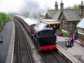
Embsay railway station is a railway station on the Embsay and Bolton Abbey Steam Railway. It serves the small village of Embsay in North Yorkshire, England. The station is a terminus on the railway and was re-opened in 1981.

Nunkeeling Priory was a priory of Benedictine nuns in the East Riding of Yorkshire, England founded by Agnes de Arches or de Catfoss in 1152. It was dedicated to St. Mary Magdalene and to St. Helen. The priory became well known and nearby Keeling was renamed Nunkeeling. The priory suffered from great poverty towards the end of the 13th century. In the early 14th century several cases of disobedience among the nuns became known, leading to disciplinary measures ordered by the archbishop of York.

Swine Priory was a priory in the village of Swine in the East Riding of Yorkshire, England. The site of the Cistercian nunnery is a Scheduled Monument.

Bonby Priory was a priory in Lincolnshire, England. St. Andrews Church is all that remains of Bonby Priory, which was a Benedictine alien priory of St. Fromond Priory from 1199 to 1403. The priory was then rented to Beauvale Abbey and the church became parochial.

Bullington Priory was a priory in Bullington, Lincolnshire, England.

Deeping St James Priory was a priory in Deeping St James, Lincolnshire, England. It was a dependency of Thorney Abbey.

St Mary Magdalene was a Benedictine priory in Lincoln, England. Along with Sandtoft Priory and Hanes Cell, it was a Lincolnshire cell of St Mary's Abbey in York, England. A surviving building, once owned by the priory, is Monks' Abbey, Lincoln.

Stainfield Priory was a Benedictine nunnery at Stainfield in the North of Lincolnshire, England, between Wragby and Fiskerton.
Torksey Priory was a priory in Lincolnshire, England. It was an Augustinian house and was dedicated to St Leonard. It is thought that the priory was founded in the time of King Henry II, possibly by the king himself. It had the three parish churches in Torksey annexed to it - All Saints, St Peter, St Mary.
Drax Priory was an Augustinian priory at Drax in North Yorkshire, England, founded between 1130 and 1139 by William Paynel. The Priory has sometimes been called an abbey, though this is judged to be incorrect. Permission was given to crenellate the priory in 1362.

Rosedale Priory was a priory in Rosedale Abbey, North Yorkshire, England that was founded c. 1150–1199. By the time the priory was suppressed in 1535, it had one prioress and eight nuns. The religious house in Rosedale was a priory and not an abbey, despite the village being given the name Rosedale Abbey, and it is unclear why this came about.
Woodkirk Priory was a cell of Augustinian Canons in West Yorkshire, England. William, second earl of Warenne, had granted the land for its foundation in 1135. It was a cell of Nostell Priory. Woodkirk became the site of a fair, granted by King Henry I and confirmed by King Stephen, which was particularly famous during the reign of King Edward II. The cell was dissolved in 1539, and the property later passed to the Savile family.

The 2015 Craven District Council election took place on 7 May 2015 to elect members of the Craven District Council in England. It was held on the same day as other local elections.
Embsay with Eastby is a civil parish in the former Craven district of North Yorkshire, England. It contains 24 listed buildings that are recorded in the National Heritage List for England. Of these, one is listed at Grade II*, the middle of the three grades, and the others are at Grade II, the lowest grade. The parish contains the villages of Embsay and Eastby and the surrounding countryside. Most of the listed buildings are houses, cottages, farmhouses and associated structures, and the others include a public house, a mounting block, a church, a former engine house, buildings associated with Embsay railway station, a war memorial, and two telephone kiosks.

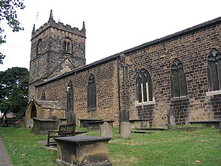
St Mary's Church is an Anglican church in Embsay with Eastby, a parish in North Yorkshire, in England.
