South San Francisco is a city in San Mateo County, California, United States, located on the San Francisco Peninsula in the San Francisco Bay Area. The city is colloquially known as "South City". The population was 66,105 at the 2020 census.

The Richmond Parkway Transit Center, or RPTC, is a park and ride lot and bus terminal located in Richmond, California. It is named after the adjacent Richmond Parkway and serves as a transfer point for WestCAT and AC Transit. The center is situated on the corner of Richmond Parkway and Blume Drive, near the Pinole border and adjacent to Interstate 80 and the Hilltop Plaza shopping center.

The Berkeley Pier is in Berkeley, California. When constructed in 1926, the pier extended 3.5 miles (5.6 km) into San Francisco Bay from the end of University Avenue. Due to extensive filling of the bay and the creation of the Berkeley Marina, it presently extends only 2.5 miles (4.0 km). Since 1937, only the first 3,000 feet (910 m) were maintained and open to the public until July 2015, when public access was closed due to safety concerns.

The Wave Organ is a sculpture located in San Francisco, California. It was constructed on the shore of San Francisco Bay in May 1986 by the Exploratorium, and more specifically, by installation artist and the Exploratorium artist-in-residence Peter Richards, who conceived and designed the organ, working with stonemason George Gonzales.

The Berkeley Marina is the westernmost portion of the city of Berkeley, California, located west of the Eastshore Freeway at the foot of University Avenue on San Francisco Bay. Narrowly speaking, "Berkeley Marina" refers only to the city marina, but in common usage, it applies more generally to the surrounding area.


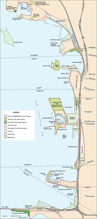
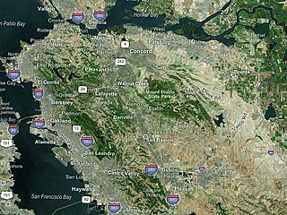
McLaughlin Eastshore State Park is a state park and wildlife refuge along the San Francisco Bay shoreline of the East Bay between the cities of Richmond, Albany, Berkeley, Emeryville, and Oakland. It encompasses remnant natural wetlands, restored wetlands, as well as landfill west of the Eastshore Freeway. Its shoreline is 8.5 miles (13.7 km) long, and its total area is 1,854 acres (750 ha), which includes both tidelands and uplands. Originally named just Eastshore State Park, it was renamed in October 2012 to honor the late Save the Bay founder Sylvia McLaughlin, who, along with the late Dwight Steele of Citizens for Eastshore Park, drove the establishment of the park. Prior to 2013, it was jointly managed by the California State Parks and East Bay Regional Park District (EBRPD). The state agency and EBRPD executed a 30-year agreement for EBRPD to manage the park.
Miller/Knox Regional Shoreline is a 295-acre (1.19 km2) bayside park near the Brickyard Cove neighborhood of the Point Richmond District in Richmond, California.

Point Isabel Regional Shoreline in Richmond, California, is operated by East Bay Regional Park District, and is a multi-use park for joggers, windsurfers, kayakers, photographers, picnickers, and people walking dogs. It has access for pedestrians and via public transit, private vehicles, and bikes. It also features a concession offering food for people and grooming for pets. A longtime community organization and nonprofit, Point Isabel Dog Owners and Friends (PIDO), is active in the maintenance and improvement of the park.
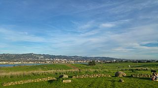
César Chávez Park is a 90 acres (36 ha) city park of Berkeley, California named after César Chávez. It can be found on the peninsula on the north side of the Berkeley Marina in the San Francisco Bay and is adjacent to Eastshore State Park.

The four Richmond Shipyards, in the city of Richmond, California, United States, were run by Permanente Metals and part of the Kaiser Shipyards. In World War II, Richmond built more ships than any other shipyard, turning out as many as three ships in a single day. The shipyards are part of the Rosie the Riveter/World War II Home Front National Historical Park, whose Rosie the Riveter memorial honors the shipyard workers. Shipyard #3 is listed on the National Register of Historic Places and is a California Historical Landmark # 1032.

Point San Pablo Harbor is a marina and small community at the far end of Point San Pablo in San Pablo Bay, within Richmond, in Contra Costa County, California. It is located at 1900 Stenmark Drive, Richmond CA 94801.

Point Molate Naval Fuel Depot is a decommissioned United States Navy fueling station on the western shore of Richmond, California on San Francisco Bay. It has undergone years of litigation and debate as to its redevelopment with proposals ranging from a billion dollar casino project, parkland, housing, and other mixed uses.

San Francisco and Oakland Helicopter Airlines was a helicopter airline service offering scheduled passenger flights between San Francisco, Oakland, and other Bay Area cities. It was founded in 1961 but disappeared from the Official Airline Guide 15 years later before finally going out of business in 1986.
Oyster Bay Regional Shoreline is a park in San Leandro, California, part of the East Bay Regional Park District (EBRPD). It is located along the eastern shore of San Francisco Bay directly to the south of Oakland International Airport. The property was originally used as a landfill for 37 years, until it was filled to capacity in 1977, when it was capped with a clay cover. EBRPD bought the property in 1980, intending to use it as a park.